Country:
 Canada
Region:
City:
Latitude and Longitude:
Time Zone:
Postal Code:
IP information under different IP Channel
ip-api
Country
Region
City
ASN
Time Zone
ISP
Blacklist
Proxy
Latitude
Longitude
Postal
Route
IPinfo
Country
Region
City
ASN
Time Zone
ISP
Blacklist
Proxy
Latitude
Longitude
Postal
Route
MaxMind
Country
Region
City
ASN
Time Zone
ISP
Blacklist
Proxy
Latitude
Longitude
Postal
Route
Luminati
Country
CARegion
ab
City
calgary
ASN
Time Zone
America/Edmonton
ISP
OXIO-ASN-01
Latitude
Longitude
Postal
db-ip
Country
Region
City
ASN
Time Zone
ISP
Blacklist
Proxy
Latitude
Longitude
Postal
Route
ipdata
Country
Region
City
ASN
Time Zone
ISP
Blacklist
Proxy
Latitude
Longitude
Postal
Route
Popular places and events near this IP address

Calgary-Elbow
Provincial electoral district in Alberta, Canada
Distance: Approx. 1480 meters
Latitude and longitude: 51.02,-114.08
Calgary-Elbow is a provincial electoral district for the Legislative Assembly of Alberta, Canada. The seat is held by NDP MLA Samir Kayande, who won the seat in the 2023 provincial election The riding was created in 1971 from the southeast part of Calgary-Glenmore and the southwest part of the old Calgary South riding. It includes the following communities: Altadore, Bel-Aire, Britannia, Elbow Park, Elboya, Erlton, Garrison Woods, Glamorgan, Lincoln Park, Mount Royal, Marda Loop, Mayfair, Meadowlark Park, North Glenmore, Parkhill, Rideau Park, Roxboro, South Calgary and Windsor Park.
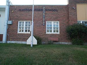
Alternative High School
Public school in Calgary, Alberta, Canada
Distance: Approx. 1419 meters
Latitude and longitude: 51.00916667,-114.10972222
Alternative High School (AHS) is a public senior high (secondary) school in Calgary, Alberta, Canada; which teaches grades 10 through 12. AHS is currently located at the Clinton Ford Centre, which was home to the former Clinton Ford Elementary School. AHS was launched, independent of the board, in September 1974 by a parents group.
Marda Loop, Calgary
Shopping district in Alberta, Canada
Distance: Approx. 909 meters
Latitude and longitude: 51.02388889,-114.11305556
Marda Loop is a shopping and dining district (i.e., a Business Improvement Area, or BIA) in southwest Calgary, Alberta. While the name "Marda Loop" originated with the BIA, it also applies generically to the surrounding community, and also to the residential Marda Loop Communities Association. This entry is primarily about the Marda Loop BIA. The area has become one of Calgary's most popular outdoor shopping venues.

The Military Museums
Distance: Approx. 1340 meters
Latitude and longitude: 51.014,-114.117
The Military Museums is a reorganization of the former Museum of the Regiments in Calgary, Alberta, announced by Sophie, Countess of Wessex, on June 3, 2006. The new museum comprises the former Museum of the Regiments as well as the relocated Naval Museum of Alberta and an Air Force Wing consisting of artifacts being acquired.
Calgary Justice Film Festival
Annual film festival in Alberta, Canada
Distance: Approx. 372 meters
Latitude and longitude: 51.0209,-114.0958
The Calgary Justice Film Festival (CJFF), formerly the Marda Loop Justice Film Festival (MLJFF), is an annual human-rights film festival that takes place in Calgary, Alberta. Held each November, the festival showcases documentaries related to environmental and social justice. In addition to documentary screenings, the CJFF hosts an ‘NGO Village’ – a gathering place where non-profit organizations can discuss with festival attendees how to advance positive change.
Clear Water Academy
Distance: Approx. 1259 meters
Latitude and longitude: 51.0196,-114.119
Clear Water Academy is a private university preparatory school managed by the Legion of Christ which is located in Calgary, Alberta. It is one of the few private Catholic schools in Alberta, and is dedicated to its four pillars for Catholic formation: Intellectual Formation, Character Formation, Apostolic Formation, and Spiritual Formation. Clear Water runs from Pre-Kindergarten to Grade Twelve, with Grades 4 through 9 being gender separated for all classes.
Altadore, Calgary
Neighbourhood in Calgary, Alberta, Canada
Distance: Approx. 297 meters
Latitude and longitude: 51.01805556,-114.10055556
Altadore is a residential neighbourhood in the inner-city portion of the southwest quadrant of Calgary, Alberta. It is bounded by 33rd Ave SW and the neighbourhood of South Calgary in the north, River Park and 14 St SW in the east, the Garrison Woods neighbourhood and Crowchild Trail SW in the west, and 50th Ave SW in the south. Altadore is part of the Marda Loop Communities Association (MLCA) along with Garrison Woods and South Calgary.
South Calgary, Calgary
Neighbourhood in Calgary, Alberta, Canada
Distance: Approx. 817 meters
Latitude and longitude: 51.02583333,-114.10944444
South Calgary is a residential neighbourhood in the southwest quadrant of Calgary, Alberta. It is located between 14th St west and Crowchild Trail. The community has an area redevelopment plan in place.
Richmond, Calgary
Neighbourhood in Calgary, Alberta, Canada
Distance: Approx. 1466 meters
Latitude and longitude: 51.03138889,-114.11333333
Richmond is a residential neighbourhood in the southwest quadrant of Calgary, Alberta. It is located on both sides of the Crowchild Trail, south of 17th Avenue SW. It was the location of Alberta Children's Hospital until 2007, when the new facility was opened in the northwest quadrant. The community has an area redevelopment plan in place.
Britannia, Calgary
Neighbourhood in Calgary, Alberta, Canada
Distance: Approx. 1556 meters
Latitude and longitude: 51.01305556,-114.0825
Britannia is an affluent residential neighbourhood in the southwest quadrant of Calgary, Alberta, Canada. It is bounded by Elbow Drive to the east, 50 Avenue S to the south, Elbow River and Riverdale Park to the west and Britannia Drive to the north. The area was annexed to the City of Calgary in 1910, and Britannia was established in 1956.
Elbow Park, Calgary
Neighbourhood in Calgary, Alberta, Canada
Distance: Approx. 1259 meters
Latitude and longitude: 51.02333333,-114.08361111
Elbow Park is an affluent residential neighbourhood in the southwest quadrant of Calgary, Alberta. It is one of the oldest and wealthiest communities in the city. It is bordered to the south and east by Elbow River, to the east by Elbow Drive, to the north by Council Way and to the west by 14 Street W. Elbow Park was annexed to the City of Calgary in 1907 and developed after 1910, when it was established as a neighbourhood.
Viscount Bennett High School
Public school in Calgary, Alberta
Distance: Approx. 1579 meters
Latitude and longitude: 51.029126,-114.119234
Viscount Bennett High School was a combined junior and senior high school in the Richmond neighbourhood of Calgary, Alberta that operated from 1955 to 1985. The city's fourth high school, Viscount was built to accommodate the baby boomer generation and the southwest suburbs that had grown rapidly after World War II. At its peak in the mid-1960s, the school had over 2,000 students. Due to the area's ageing population and the opening of other high schools nearby, after only 30 years Viscount Bennett closed in 1985.
Weather in this IP's area
broken clouds
16 Celsius
15 Celsius
15 Celsius
17 Celsius
1007 hPa
61 %
1007 hPa
886 hPa
10000 meters
3.09 m/s
350 degree
75 %
07:17:18
19:43:30