Country:
 Canada
Region:
City:
Latitude and Longitude:
Time Zone:
Postal Code:
IP information under different IP Channel
ip-api
Country
Region
City
ASN
Time Zone
ISP
Blacklist
Proxy
Latitude
Longitude
Postal
Route
IPinfo
Country
Region
City
ASN
Time Zone
ISP
Blacklist
Proxy
Latitude
Longitude
Postal
Route
MaxMind
Country
Region
City
ASN
Time Zone
ISP
Blacklist
Proxy
Latitude
Longitude
Postal
Route
Luminati
Country
CARegion
ab
City
calgary
ASN
Time Zone
America/Edmonton
ISP
OXIO-ASN-01
Latitude
Longitude
Postal
db-ip
Country
Region
City
ASN
Time Zone
ISP
Blacklist
Proxy
Latitude
Longitude
Postal
Route
ipdata
Country
Region
City
ASN
Time Zone
ISP
Blacklist
Proxy
Latitude
Longitude
Postal
Route
Popular places and events near this IP address
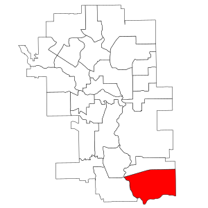
Calgary-South East
Provincial electoral district in Alberta, Canada
Distance: Approx. 1749 meters
Latitude and longitude: 50.88,-113.94
Calgary-South East (previously styled Calgary South East) is a provincial electoral district in Calgary, Alberta. It has existed twice, first from 1959 to 1963, and then re-created in 2010. The district is mandated to return a single member to the Legislative Assembly of Alberta.
McKenzie Lake, Calgary
Neighbourhood in Calgary, Alberta, Canada
Distance: Approx. 2795 meters
Latitude and longitude: 50.90777778,-113.98722222
McKenzie Lake is a residential neighbourhood in southeast Calgary, Alberta. The community was in development from the mid-1980s through to present. The area is bordered by Deerfoot Trail on the east, Stoney Trail on the south, Fish Creek Provincial Park on the west, and 130th Ave SE on the north.
McKenzie Towne, Calgary
Neighbourhood in Calgary, Alberta, Canada
Distance: Approx. 2745 meters
Latitude and longitude: 50.91361111,-113.96916667
McKenzie Towne is a master planned residential neighbourhood in the southeast of Calgary, Alberta being developed by Carma Developers LP (now Brookfield Residential Properties Inc.). The community is bordered on the west by Deerfoot Trail, on the south by Stoney Trail, on the east by 52 St. S.E., and to the north by the South Trail regional commercial centre along 130 Ave.
Copperfield, Calgary
Neighbourhood in Calgary, Alberta, Canada
Distance: Approx. 2668 meters
Latitude and longitude: 50.91083333,-113.94166667
Copperfield is a neighbourhood in the southeast quadrant of Calgary, Alberta. The neighbourhood is bounded by 52nd St. to the west, Stoney Trail to the south, and the neighbourhood of New Brighton to the north.
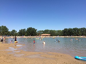
Sikome Lake
Man-made lake in Alberta, Canada
Distance: Approx. 4076 meters
Latitude and longitude: 50.89944444,-114.01555556
The Sikome Aquatic Facility, commonly referred to as Sikome Lake, is a man-made lake in the city of Calgary, Alberta, Canada. It is located in the southeast quadrant of the city, within the Fish Creek Provincial Park, and is part of the Bow River basin. It lies at an elevation of 1,005 m (3,297 ft) and has a surface of 0.4 km2 (40 ha; 99 acres).
Cranston, Calgary
Neighbourhood in Calgary, Alberta, Canada
Distance: Approx. 1709 meters
Latitude and longitude: 50.89222222,-113.98361111
Cranston is a master planned residential community in the southeast quadrant of Calgary, Alberta by Carma Developments who started development of the farming land in 1999. Cranston contains a wide range of single family and multi family residential as well as commercial property. It has two public elementary schools and one separate board K-9 school, as well as Century Hall - a private Cranston residents recreation facility.

New Brighton, Calgary
Neighbourhood in Calgary, Alberta, Canada
Distance: Approx. 3563 meters
Latitude and longitude: 50.92138889,-113.9525
New Brighton is a master–planned residential neighbourhood developed in the southeast of Calgary, Alberta. Located east of 52nd Street SE and south of 130th Ave and McIvor Boulevard to the south. The community contains a variety of single family and multi-family homes as well as a private residents' association recreation facility called the New Brighton Club.
Auburn Bay, Calgary
Distance: Approx. 577 meters
Latitude and longitude: 50.88527778,-113.96388889
Auburn Bay is a suburban residential neighbourhood in the southeast quadrant of Calgary, Alberta. It is located at the southeastern edge of the city, and is bounded by Seton Boulevard to the south, Deerfoot Trail to the west, 52 Street E to the east and Stoney Trail to the north. It was established in 2005.
Seton, Calgary
Neighbourhood in Calgary, Alberta, Canada
Distance: Approx. 1292 meters
Latitude and longitude: 50.879,-113.95246944
Seton is a suburban residential/commercial/institutional community under construction in southeast Calgary, Alberta, Canada. It is located directly south of Auburn Bay and east of Cranston. Its boundaries are presently Deerfoot Trail to the west, Seton Blvd.
Mahogany, Calgary
Suburban residential neighborhood in Calgary, Alberta, Canada
Distance: Approx. 2686 meters
Latitude and longitude: 50.9,-113.925
Mahogany is a suburban residential neighbourhood in Calgary, Alberta that was approved by its city council for development beginning in 2007. The community is bordered by 52 St SE to the west, along with the community of Auburn Bay, Stoney Trail to the north, the proposed East Freeway to the east, and an eastern extension of Seton Boulevard (dubbed 196 Avenue SE) to the south. Mahogany is being developed by Hopewell Residential Communities of Calgary.
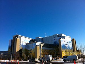
South Health Campus
Hospital in Alberta, Canada
Distance: Approx. 940 meters
Latitude and longitude: 50.882778,-113.951944
South Health Campus (SHC) is a large hospital in Calgary, in Alberta, Canada. It is administered by Alberta Health Services. The building was developed by Alberta Infrastructure, and the first phase was built at a cost of $1.31 billion.
Joane Cardinal-Schubert High School
Public school in Calgary, Alberta, Canada
Distance: Approx. 1655 meters
Latitude and longitude: 50.878306,-113.944467
Joane Cardinal-Schubert High School (JCS) is a public high school in Calgary, Alberta, Canada operated by the Calgary Board of Education. It was founded in 2018 and the first year of attendance was 1129 students. It has approximately 1,800 students and 60 staff members.
Weather in this IP's area
overcast clouds
16 Celsius
16 Celsius
14 Celsius
17 Celsius
1007 hPa
62 %
1007 hPa
891 hPa
10000 meters
2.92 m/s
4.53 m/s
337 degree
100 %
07:16:47
19:42:53