38.147.204.180 - IP Lookup: Free IP Address Lookup, Postal Code Lookup, IP Location Lookup, IP ASN, Public IP
Country:
Region:
City:
Location:
Time Zone:
Postal Code:
IP information under different IP Channel
ip-api
Country
Region
City
ASN
Time Zone
ISP
Blacklist
Proxy
Latitude
Longitude
Postal
Route
Luminati
Country
Region
nh
City
jefferson
ASN
Time Zone
America/New_York
ISP
TVC-AS1
Latitude
Longitude
Postal
IPinfo
Country
Region
City
ASN
Time Zone
ISP
Blacklist
Proxy
Latitude
Longitude
Postal
Route
IP2Location
38.147.204.180Country
Region
massachusetts
City
bridgewater
Time Zone
America/New_York
ISP
Language
User-Agent
Latitude
Longitude
Postal
db-ip
Country
Region
City
ASN
Time Zone
ISP
Blacklist
Proxy
Latitude
Longitude
Postal
Route
ipdata
Country
Region
City
ASN
Time Zone
ISP
Blacklist
Proxy
Latitude
Longitude
Postal
Route
Popular places and events near this IP address

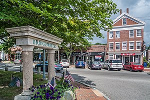
Bridgewater (CDP), Massachusetts
Census-designated place in Massachusetts, United States
Distance: Approx. 1300 meters
Latitude and longitude: 41.99,-70.97333333
Bridgewater was a census-designated place (CDP) in the town of Bridgewater in Plymouth County, Massachusetts, United States. The CDP ceased to exist when Bridgewater was given de facto city status in 2010. The population was 7,841 at the 2010 census.

Bridgewater, Massachusetts
City in Massachusetts, United States
Distance: Approx. 1323 meters
Latitude and longitude: 41.99027778,-70.97555556
Bridgewater is a town located in Plymouth County, in the state of Massachusetts, United States. As of the 2020 U.S. Census, the town's population was 28,633. Bridgewater is located approximately 25 miles (40 km) south of Boston and approximately 35 miles east of Providence, Rhode Island.
Bridgewater-Raynham Regional High School
Public school in Bridgewater, Massachusetts, United States
Distance: Approx. 1535 meters
Latitude and longitude: 41.9891,-70.9868
Bridgewater Raynham Regional High School, founded in 1961, is a regional high school in Bridgewater, Massachusetts, shared by the City of Bridgewater and the Town of Raynham. The high school, commonly referred to as B-R, relocated to a new building at 415 Center Street in 2007. The athletic teams are called the Trojans and the school colors are red and white.

Taunton River Watershed
Distance: Approx. 3166 meters
Latitude and longitude: 42,-71
The Taunton River watershed or Taunton River basin is made up of 562 square miles (1,500 km2) of rivers, lakes, ponds, streams, and wetlands in southeastern Massachusetts, US. It is the second largest watershed in the state. Also, it is a significant part of a much larger multi-state watershed, the Narragansett Bay watershed. The Taunton River watershed is mostly situated in Bristol County and western Plymouth County, while some portions of it extends into parts of southern Norfolk County.

Town River
River in Plymouth County, Massachusetts
Distance: Approx. 3212 meters
Latitude and longitude: 41.99583333,-70.94416667
The Town River is a river in Plymouth County, Massachusetts, United States. It flows 10.6 miles (17.1 km) from the northeast end of Lake Nippenicket in the town of Bridgewater, flowing easterly through West Bridgewater, then south back into Bridgewater where it joins with the Matfield River to form the Taunton River.

Satucket River
River in the United States of America
Distance: Approx. 4163 meters
Latitude and longitude: 42.0125,-70.95444444
The Satucket River is 5.5-mile-long (8.9 km) river in southeastern Massachusetts within the Taunton River Watershed. It flows generally west from Robbins Pond in East Bridgewater, and into the Matfield River.The Satucket River drains a watershed of 34.9 square miles and 700 acres of natural ponds."Satucket River, East Bridgewater Mass. Fish Passage and Boating Improvement Project".
Bridgewater station (MBTA)
Railway station in Bridgewater, Massachusetts, US
Distance: Approx. 1087 meters
Latitude and longitude: 41.9853,-70.9658
Bridgewater station is an MBTA Commuter Rail station in Bridgewater, Massachusetts, served by the Middleborough/Lakeville Line. It is located on the east end of the Bridgewater State University campus along the Middleborough Main Line.

WBIM-FM
Radio station in Massachusetts, United States
Distance: Approx. 1055 meters
Latitude and longitude: 41.98758333,-70.97197222
WBIM-FM (91.5 FM) is a non-commercial, educational radio station broadcasting 24/7 from the campus of Bridgewater State University. The station has a mostly alternative and indie rock format during regular automation, but the station does have many specialty shows which cater to such formats as R&B, metal, jazz, hip hop, sports, decade specific, and many other formats. Licensed to Bridgewater, Massachusetts, United States, the station is owned by Bridgewater State University.
Bridgewater State Hospital
Correctional facility in Massachusetts, USA
Distance: Approx. 4008 meters
Latitude and longitude: 41.94666667,-70.95222222
Bridgewater State Hospital, located in southeastern Massachusetts, is a state facility housing the criminally insane and those whose sanity is being evaluated for the criminal justice system. It was established in 1855 as an almshouse. It was then used as a workhouse for inmates with short sentences who worked the surrounding farmland.

William H. McElwain School
United States historic place
Distance: Approx. 1979 meters
Latitude and longitude: 41.99555556,-70.98138889
The William H. McElwain School is a historic school building at 250 Main Street in Bridgewater, Massachusetts. The two story brick Classical Revival building was built in 1912 to a design by the architectural firm of Loring & Phipps. The school was named for William H. McElwain (1867-1908), the founder of the William H. McElwain Shoe Company, a shoe manufacturer who was one of the major employers in Bridgewater at the turn of the 20th century.
Massachusetts Treatment Center
Distance: Approx. 4071 meters
Latitude and longitude: 41.945126,-70.954682
The Massachusetts Treatment Center is a medium-security secured facility for men, operated by the Massachusetts Department of Correction. The facility is located within the Bridgewater Correctional Complex and houses both state prison inmates convicted of sex crimes and civilly committed persons deemed 'sexually dangerous' by a court of law. This civil commitment process is determined by Massachusetts General Law Chapter 123A. On January 6, 2020, there was 572 inmates in general population beds.
Bridgewater Ice Arena
Ice hockey rink in Massachusetts, US
Distance: Approx. 2908 meters
Latitude and longitude: 41.95245,-70.97107
The Bridgewater Ice Arena in Bridgewater, Massachusetts is a dual-surface public ice hockey rink. The facility is currently used by both the Bridgewater Bandits and Stonehill Skyhawks as a home venue.
Weather in this IP's area
clear sky
-4 Celsius
-4 Celsius
-5 Celsius
-1 Celsius
1029 hPa
78 %
1029 hPa
1027 hPa
10000 meters
