Country:
 USA
USARegion:
City:
Latitude and Longitude:
Time Zone:
Postal Code:
IP information under different IP Channel
ip-api
Country
Region
City
ASN
Time Zone
ISP
Blacklist
Proxy
Latitude
Longitude
Postal
Route
IPinfo
Country
Region
City
ASN
Time Zone
ISP
Blacklist
Proxy
Latitude
Longitude
Postal
Route
MaxMind
Country
Region
City
ASN
Time Zone
ISP
Blacklist
Proxy
Latitude
Longitude
Postal
Route
Luminati
Country
USRegion
nh
City
lancaster
ASN
Time Zone
America/New_York
ISP
TVC-AS1
Latitude
Longitude
Postal
db-ip
Country
Region
City
ASN
Time Zone
ISP
Blacklist
Proxy
Latitude
Longitude
Postal
Route
ipdata
Country
Region
City
ASN
Time Zone
ISP
Blacklist
Proxy
Latitude
Longitude
Postal
Route
Popular places and events near this IP address
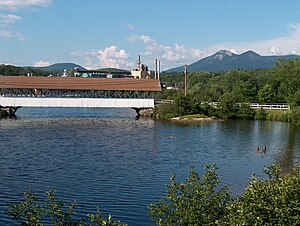
Groveton, New Hampshire
Census-designated place in New Hampshire, United States
Distance: Approx. 485 meters
Latitude and longitude: 44.59888889,-71.51444444
Groveton is a census-designated place (CDP) and the primary village in the town of Northumberland in Coos County, New Hampshire, United States. The population was 1,068 at the 2020 census. It is located at the intersection of U.S. Route 3 and New Hampshire Route 110.
Northumberland, New Hampshire
Town in New Hampshire, United States
Distance: Approx. 5481 meters
Latitude and longitude: 44.56333333,-71.55861111
Northumberland is a town located in western Coös County, New Hampshire, United States, north of Lancaster. It is part of the Berlin, NH–VT micropolitan statistical area. As of the 2020 census, the town population was 2,126, of whom 1,068 lived in the village of Groveton.

Stark, New Hampshire
Town in New Hampshire, United States
Distance: Approx. 7902 meters
Latitude and longitude: 44.60138889,-71.40916667
Stark is a town in Coös County, New Hampshire, United States. The population was 478 at the 2020 census, a decline from the figure of 556 tabulated in 2010. It has a famous covered bridge.
Stratford, New Hampshire
Town in New Hampshire, United States
Distance: Approx. 7454 meters
Latitude and longitude: 44.65416667,-71.55861111
Stratford is a town located on the Connecticut River in Coös County, New Hampshire, United States. The population was 662 at the 2020 census, a decline from the figure of 746 tabulated in 2010. Within the town are the villages of North Stratford, Stratford Hollow, and Beatties.

Upper Ammonoosuc River
River in New Hampshire, United States
Distance: Approx. 2277 meters
Latitude and longitude: 44.58833333,-71.53444444
The Upper Ammonoosuc River is a tributary of the Connecticut River that flows through Coös County in the northern part of the northeastern U.S. state of New Hampshire. Despite its name, the river is not an upstream portion of the Ammonoosuc River, but instead a separate tributary of the Connecticut River flowing from 20 to 60 miles (32 to 97 km) north of the Ammonoosuc. The Upper Ammonoosuc rises in Pond of Safety in the town of Randolph, runs first generally north through rural portions of Berlin (where it flows through the Godfrey Dam), Milan and a corner of Dummer, then west through Stark and then Northumberland, where it drains into the Connecticut near the village of Groveton.
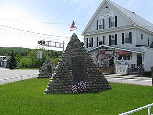
Fort Wentworth
Distance: Approx. 2391 meters
Latitude and longitude: 44.585,-71.53333333
Fort Wentworth was built by order of Benning Wentworth in 1755. The fort was built at the junction of the Upper Ammonoosuc River and Connecticut River, in Northumberland, New Hampshire, by soldiers of Colonel Joseph Blanchard's New Hampshire Provincial Regiment including Robert Rogers. In 1759, Rogers' Rangers returned here hoping for resupply after their raid on St.
Nash Stream
River in New Hampshire, United States
Distance: Approx. 4622 meters
Latitude and longitude: 44.62555556,-71.46583333
Nash Stream is a 15.3-mile-long (24.6 km) river in northern New Hampshire in the United States. It is a tributary of the Upper Ammonoosuc River and part of the Connecticut River watershed. Nash Stream rises on the western slopes of Whitcomb Mountain in the township of Odell, New Hampshire, and flows west briefly into the town of Columbia before turning south-southwest to flow through Odell and the town of Stratford, joining the Upper Ammonoosuc River in the town of Stark.
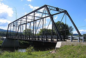
Janice Peaslee Bridge
Bridge in New Hampshire to Maidstone, Vermont
Distance: Approx. 7411 meters
Latitude and longitude: 44.65185833,-71.5625
The Janice Peaslee Bridge (formerly known as the Maidstone-Stratford Hollow Bridge) is a pin-connected steel & wrought iron Pratt through truss bridge crossing the Connecticut River between Stratford, New Hampshire and Maidstone, Vermont.
Stark Union Church
Historic church in New Hampshire, United States
Distance: Approx. 7811 meters
Latitude and longitude: 44.60091667,-71.41027778
The Stark Union Church (also known as the Stark Church) is a historic church on NH 110 in Stark, New Hampshire. Built in 1853 to serve as non-denominational worship space, it is a well-preserved example of mid-19th century vernacular church architecture. The building was listed on the National Register of Historic Places in 1983.

Guildhall Village Historic District
Historic district in Vermont, United States
Distance: Approx. 5563 meters
Latitude and longitude: 44.56555556,-71.56277778
The Guildhall Village Historic District encompasses the central common and surrounding buildings in the village center of Guildhall, Vermont. The town, the first to be settled in Vermont's Northeast Kingdom, has a history from the late 18th century as a commercial, civic, and industrial center, and is the shire town of Essex County. The district was listed on the National Register of Historic Places in 1980.
Devils Slide State Forest
State forest in Coos County, New Hampshire
Distance: Approx. 7278 meters
Latitude and longitude: 44.61194444,-71.41916667
Devils Slide State Forest is a 290-acre (120 ha) state forest in Stark, New Hampshire. It is part of a contiguous area of more than 2,000 acres (810 ha) of protected lands that includes the Kauffmann Forest and Percy State Forest.
Kauffmann Forest
Distance: Approx. 7945 meters
Latitude and longitude: 44.62,-71.41361111
Kauffmann Forest is a protected area around Christine Lake in Coos County, New Hampshire. It is owned by the Percy Summer Club and is protected by a conservation easement held by the Society for the Protection of New Hampshire Forests.
Weather in this IP's area
heavy intensity rain
12 Celsius
12 Celsius
12 Celsius
13 Celsius
1008 hPa
98 %
1008 hPa
974 hPa
10000 meters
0.5 m/s
1 m/s
336 degree
100 %
06:16:15
19:11:55