Country:
 Canada
Region:
City:
Latitude and Longitude:
Time Zone:
Postal Code:
IP information under different IP Channel
ip-api
Country
Region
City
ASN
Time Zone
ISP
Blacklist
Proxy
Latitude
Longitude
Postal
Route
IPinfo
Country
Region
City
ASN
Time Zone
ISP
Blacklist
Proxy
Latitude
Longitude
Postal
Route
MaxMind
Country
Region
City
ASN
Time Zone
ISP
Blacklist
Proxy
Latitude
Longitude
Postal
Route
Luminati
Country
CARegion
bc
City
vancouver
ASN
Time Zone
America/Vancouver
ISP
OXIO-ASN-01
Latitude
Longitude
Postal
db-ip
Country
Region
City
ASN
Time Zone
ISP
Blacklist
Proxy
Latitude
Longitude
Postal
Route
ipdata
Country
Region
City
ASN
Time Zone
ISP
Blacklist
Proxy
Latitude
Longitude
Postal
Route
Popular places and events near this IP address
Japantown, Vancouver
Distance: Approx. 698 meters
Latitude and longitude: 49.28312,-123.0953
Japantown, Little Tokyo or Paueru-gai (パウエル街, lit. "Powell Street") is an old neighbourhood in Vancouver, British Columbia, Canada, located east of Gastown and north of Chinatown, that once had a concentration of Japanese immigrants. Japantown ceased to be a distinct Japanese ethnic area during World War II when Japanese Canadians had their property confiscated and were interned.

Hogan's Alley, Vancouver
Alley in Vancouver, British Columbia
Distance: Approx. 687 meters
Latitude and longitude: 49.2772,-123.0973
Hogan's Alley was the local, unofficial name for Park Lane, an alley that ran through the southwestern corner of Strathcona in Vancouver, British Columbia, Canada. The alley was located between Union and Prior (north–south) and ran from approximately Main Street to Jackson Avenue (west–east). The area was ethnically diverse, populated by Black, Italian, Chinese, Japanese, Jewish, and Indigenous residents during the first six decades of the twentieth century.

Strathcona, Vancouver
Neighbourhood in Vancouver, Metro Vancouver
Distance: Approx. 59 meters
Latitude and longitude: 49.27916667,-123.0875
Strathcona is the oldest residential neighbourhood of Vancouver, British Columbia, Canada. Officially a part of the East Side, it is bordered by Downtown Vancouver's Chinatown neighbourhood and the False Creek inlet (across Main Street) to the west, Downtown Eastside (across Hastings Street) to the north, Grandview-Woodland (across Clark Drive) to the east, and Mount Pleasant to the south of Emily Carr University and the Canadian National Railway and Great Northern Railway (now BNSF Railway) classification yards. By some definitions, Strathcona's northern border is the roads just south of Burrard Inlet, and much of the Downtown Eastside lies within Strathcona.

Oppenheimer Park
Park in Vancouver, British Columbia, Canada
Distance: Approx. 608 meters
Latitude and longitude: 49.282675,-123.094254
Oppenheimer Park is a park located in the historic Japantown (Paueru-Gai) in the Downtown Eastside, Vancouver, British Columbia, Canada.

Fountain Chapel
Distance: Approx. 465 meters
Latitude and longitude: 49.277,-123.0939
The Fountain Chapel was a church located at 823 Jackson Avenue in Vancouver, British Columbia from 1918 until 1985. It was the local chapter of the African Methodist Episcopal Church (AME) and was co-founded by Nora Hendrix (grandmother of guitarist Jimi Hendrix) to serve Vancouver's black community. Although not officially designated a heritage structure, the building is one of a few markers of the black community that once flourished in this part of Vancouver.

Firehall Arts Centre
Arts centre in Vancouver, Canada
Distance: Approx. 789 meters
Latitude and longitude: 49.28205,-123.09793
The Firehall Arts Centre (also called the Firehall Centre for the Arts) is an arts centre in the Downtown Eastside of Vancouver, British Columbia, Canada. The building also falls within the borders of Gastown. Firehall is a small building, originally built as a fire station in 1906.
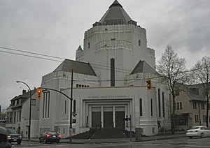
St. James Anglican Church (Vancouver)
Church in British Columbia, Canada
Distance: Approx. 770 meters
Latitude and longitude: 49.28249,-123.09727
St. James' Anglican Church (Saint James Parish of Vancouver, BC) is a unique church building in the Diocese of New Westminster of the Anglican Church of Canada located at the north-east corner of East Cordova Street and Gore Avenue in the City of Vancouver, British Columbia, Canada's Downtown Eastside district of the Strathcona neighbourhood. The Parish boundaries are Burrard Inlet on the north, Cambie Street on the west, Clarke Drive on the East and a portion of Falser Creek and Terminal Avenue on the south.

Vancouver Japanese Language School
School in Canada
Distance: Approx. 707 meters
Latitude and longitude: 49.2841,-123.0938
Vancouver Japanese Language School (バンクーバー日本語学校, Vancouver Nihongo Gakko) is a language school located in Japantown, Vancouver, BC. Founded in 1906 as Vancouver Kyoritsu Nihon Kokumin Gakko (晩香坡共立日本國民學校, Vancouver Japanese Citizens' School), it is the oldest Japanese language school in Canada.

Kissa Tanto
Restaurant in Vancouver
Distance: Approx. 739 meters
Latitude and longitude: 49.28055556,-123.09805556
Kissa Tanto is an Italian-Japanese fusion restaurant in the Chinatown neighborhood of Vancouver, British Columbia, Canada. The 80-seat restaurant, which opened in June 2016, is on the second floor of 263 E Pender St. Its name comes from the Japanese word kissa, referring to the "jazz kissa" or jazz cafes of 1960s Tokyo, and the Italian word tanto, meaning "a lot" or "so much".
Barbara (restaurant)
Restaurant in Vancouver, British Columbia
Distance: Approx. 660 meters
Latitude and longitude: 49.28044444,-123.09697222
Barbara is a restaurant in Vancouver, British Columbia. The restaurant has received a Michelin star.
Astoria Hotel (Vancouver)
Historic hotel in Canada, 1913 to 1950
Distance: Approx. 280 meters
Latitude and longitude: 49.28141,-123.08792
The Astoria Hotel is a historic hotel turned into single-room occupancy accommodations located at 769 East Hastings Street in the Downtown Eastside neighborhood of Vancouver, Canada. The hotel was opened in 1913 as the Toronto House Apartments before becoming the Astoria Hotel in 1950. The main floor of the hotel serves as a bar and events space.

Kuomintang Building (Vancouver)
Historic building in Chinatown, Vancouver
Distance: Approx. 695 meters
Latitude and longitude: 49.28019444,-123.09755556
The Kuomintang Building (Chinese: 國民黨大樓), also known as the Chinese Nationalist League Building, is a historic four-storey building in Vancouver, British Columbia, Canada. It is located in the southeast corner of the city's Chinatown, at the intersection of Gore Avenue and Pender Street. Opened in 1921, it originally served as the Western Canadian headquarters of the Kuomintang, a Chinese nationalist organization.
Weather in this IP's area
few clouds
17 Celsius
17 Celsius
15 Celsius
18 Celsius
1015 hPa
81 %
1015 hPa
1013 hPa
10000 meters
3.6 m/s
210 degree
20 %
06:53:57
19:18:44