Country:
 Canada
Region:
City:
Latitude and Longitude:
Time Zone:
Postal Code:
IP information under different IP Channel
ip-api
Country
Region
City
ASN
Time Zone
ISP
Blacklist
Proxy
Latitude
Longitude
Postal
Route
IPinfo
Country
Region
City
ASN
Time Zone
ISP
Blacklist
Proxy
Latitude
Longitude
Postal
Route
MaxMind
Country
Region
City
ASN
Time Zone
ISP
Blacklist
Proxy
Latitude
Longitude
Postal
Route
Luminati
Country
CARegion
bc
City
coquitlam
ASN
Time Zone
America/Vancouver
ISP
OXIO-ASN-01
Latitude
Longitude
Postal
db-ip
Country
Region
City
ASN
Time Zone
ISP
Blacklist
Proxy
Latitude
Longitude
Postal
Route
ipdata
Country
Region
City
ASN
Time Zone
ISP
Blacklist
Proxy
Latitude
Longitude
Postal
Route
Popular places and events near this IP address
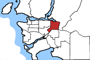
New Westminster—Coquitlam
Federal electoral district in British Columbia, Canada
Distance: Approx. 2356 meters
Latitude and longitude: 49.252,-122.85
New Westminster—Coquitlam was a federal electoral district in British Columbia, Canada, that was represented in the House of Commons of Canada from 1979 to 1988, and from 2004 to 2015.
Burquitlam (electoral district)
Defunct provincial electoral district in British Columbia, Canada
Distance: Approx. 1005 meters
Latitude and longitude: 49.26,-122.864
Burquitlam was a provincial electoral district for the Legislative Assembly of British Columbia, Canada from 2001 to 2009.

PoMo Museum
Railway Museum in British Columbia, Canada
Distance: Approx. 2216 meters
Latitude and longitude: 49.279258,-122.850747
POMO Museum (formerly known as the Port Moody Station Museum) is owned and operated by the Port Moody Heritage Society and is part of their effort to promote increased awareness and knowledge of Port Moody, British Columbia's heritage and history.

Port Moody Secondary School
Coeducational public secondary school in Port Moody, British Columbia, Canada
Distance: Approx. 927 meters
Latitude and longitude: 49.27361111,-122.86777778
Port Moody Secondary School is a public coeducational high school located in Port Moody, British Columbia. The school offers the International Baccalaureate Program and the Career Preparation Program to its students. There are approximately 400 students in the pre-International Baccalaureate Diploma programme and the International Baccalaureate diploma programme tracks.
The City of Lougheed
Shopping mall
Distance: Approx. 2340 meters
Latitude and longitude: 49.251049,-122.89606
The City of Lougheed is the second-largest shopping centre in Burnaby, British Columbia, Canada, with 57,100 square metres (615,000 sq ft) and over 160 shops and services. It opened in 1969 and is located in the northeast corner of Burnaby near the Coquitlam border. The centre is located adjacent to Lougheed Town Centre station, an interchange station that connects the Expo Line and Millennium Line of Metro Vancouver's SkyTrain rapid transit system.
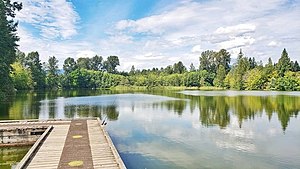
Como Lake (British Columbia)
Lake in British Columbia, Canada
Distance: Approx. 1310 meters
Latitude and longitude: 49.2604,-122.8583
Como Lake is a small lake in Como Lake Park in the city of Coquitlam, British Columbia. It forms the headwaters of the Como watershed and is an urban fishing and recreation area in the city of Coquitlam as well as the Lower Mainland. The lake is very popular with joggers and walkers, the trail around the lake being 1 km in length.

Burquitlam station
Metro Vancouver SkyTrain station
Distance: Approx. 1273 meters
Latitude and longitude: 49.26138889,-122.88972222
Burquitlam station is a rapid transit station on the Millennium Line, part of Metro Vancouver's SkyTrain system, and is located in Coquitlam, a suburb of Vancouver, British Columbia, Canada. It opened on December 2, 2016, with the rest of the Evergreen Extension and is named after the Burquitlam neighbourhood in which it is located. The station features a transit exchange (including a direct connection to Simon Fraser University), HandyDart area, night bus service to and from Downtown Vancouver, and bike lockers and racks.
Vancouver Golf Club
Distance: Approx. 1729 meters
Latitude and longitude: 49.251,-122.878
Vancouver Golf Club, located in the Canadian city of Coquitlam, British Columbia, is the oldest golf club in the Lower Mainland. Established 114 years ago in 1910, it opened the following year on a former sheep farm on the west side of Blue Mountain. The suburban club was originally considered to be far outside of the major population centre of Vancouver, requiring a trip on the British Columbia Electric Railway and often an overnight stay at the club.
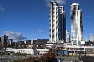
Burquitlam, British Columbia
Neighbourhood of Coquitlam in Lower Mainland, British Columbia, Canada
Distance: Approx. 1233 meters
Latitude and longitude: 49.26111111,-122.88888889
Burquitlam is a neighbourhood and commercial district of the City of Coquitlam, British Columbia, Canada.
1988 du Maurier Classic
Distance: Approx. 1708 meters
Latitude and longitude: 49.251136,-122.877497
The 1988 du Maurier Classic was contested from June 30 to July 3 at Vancouver Golf Club in Coquitlam, British Columbia. It was the 16th edition of the du Maurier Classic, and the 10th edition as a major championship on the LPGA Tour. This event was won by Sally Little.
1991 du Maurier Classic
Distance: Approx. 1708 meters
Latitude and longitude: 49.251136,-122.877497
The 1991 du Maurier Classic was contested from September 12–15 at Vancouver Golf Club. It was the 19th edition of the du Maurier Classic, and the 13th edition as a major championship on the LPGA Tour. This event was won by Nancy Scranton.
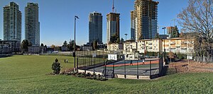
Como Lake Park (British Columbia)
Park in British Columbia, Canada
Distance: Approx. 1233 meters
Latitude and longitude: 49.261,-122.859
Como Lake Park is a small park in Coquitlam, British Columbia, Canada. Como Lake is located in the centre of the park and is surrounded by a one-kilometre-long trail.
Weather in this IP's area
broken clouds
16 Celsius
16 Celsius
15 Celsius
17 Celsius
1015 hPa
74 %
1015 hPa
1001 hPa
10000 meters
0.76 m/s
0.9 m/s
178 degree
70 %
06:53:06
19:17:53