Country:
 Canada
Region:
City:
Latitude and Longitude:
Time Zone:
Postal Code:
IP information under different IP Channel
ip-api
Country
Region
City
ASN
Time Zone
ISP
Blacklist
Proxy
Latitude
Longitude
Postal
Route
IPinfo
Country
Region
City
ASN
Time Zone
ISP
Blacklist
Proxy
Latitude
Longitude
Postal
Route
MaxMind
Country
Region
City
ASN
Time Zone
ISP
Blacklist
Proxy
Latitude
Longitude
Postal
Route
Luminati
Country
CARegion
bc
City
vancouver
ASN
Time Zone
America/Vancouver
ISP
OXIO-ASN-01
Latitude
Longitude
Postal
db-ip
Country
Region
City
ASN
Time Zone
ISP
Blacklist
Proxy
Latitude
Longitude
Postal
Route
ipdata
Country
Region
City
ASN
Time Zone
ISP
Blacklist
Proxy
Latitude
Longitude
Postal
Route
Popular places and events near this IP address
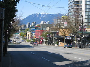
South Granville, Vancouver
Neighbourhood in Vancouver, British Columbia, Canada
Distance: Approx. 822 meters
Latitude and longitude: 49.2342,-123.142
Established in 1997, South Granville (or less commonly "Uptown") is an upscale Business Improvement Area (BIA) and neighbourhood south of Vancouver's downtown core, centred along Granville Street and bordered by the neighbourhoods of Kitsilano, Fairview and Shaughnessy. Separated from Downtown by False Creek, the area runs along Granville Street from the south side of the Granville Street Bridge up to 16th Ave, where storefronts are replaced by the residences and hedges of Shaughnessy. 1907 has been decided as the unofficial birth year of the neighbourhood.

Kerrisdale
Neighborhood in Vancouver, BC, Canada
Distance: Approx. 1448 meters
Latitude and longitude: 49.2236,-123.1595
Kerrisdale is a neighbourhood in the city of Vancouver, British Columbia, Canada. Kerrisdale is a neighbourhood located in Vancouver's west side. It features a mix of newer houses and older bungalows as well as various low and mid-rise rental and condo apartment buildings in its northern section.

VanDusen Botanical Garden
Distance: Approx. 1569 meters
Latitude and longitude: 49.23972222,-123.13222222
VanDusen Botanical Garden is a botanical garden situated in Vancouver, British Columbia, in the Shaughnessy neighborhood. It is located at the northwest corner of 37th Avenue and Oak Street. It is named for local lumberman and philanthropist Whitford Julian VanDusen.
York House School
Private school in Vancouver, British Columbia, Canada
Distance: Approx. 1705 meters
Latitude and longitude: 49.2491,-123.1411
York House School is an independent day school for girls located in the heart of Shaughnessy, Vancouver, British Columbia, Canada.
Eric Hamber Secondary School
Secondary school in Vancouver, British Columbia, Canada
Distance: Approx. 2086 meters
Latitude and longitude: 49.24,-123.125
Eric Hamber Secondary School is a public secondary school located in the South Cambie neighbourhood of Vancouver, British Columbia, Canada. Eric Hamber is a comprehensive secondary school with approximately 1400 students. Each year, approximately 70% of the senior class graduate with honours standing.

Prince of Wales Secondary School
Secondary school in Vancouver, British Columbia, Canada
Distance: Approx. 1135 meters
Latitude and longitude: 49.2456,-123.1578
Prince of Wales Secondary School is a public secondary school located in Vancouver, British Columbia, Canada.

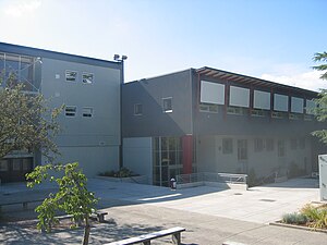
Point Grey Secondary School
Secondary school in Vancouver, British Columbia, Canada
Distance: Approx. 122 meters
Latitude and longitude: 49.237,-123.153
Point Grey stəywəte:n̓ Secondary School (English: ), previously called Point Grey Secondary School, is a public secondary school located in the Kerrisdale and Shaughnessy neighbourhoods of Vancouver, British Columbia, Canada.

Magee Secondary School
Secondary school in Vancouver, British Columbia, Canada
Distance: Approx. 772 meters
Latitude and longitude: 49.229,-123.152
Magee Secondary School is a public secondary school on West 49th Avenue, Vancouver, British Columbia, Canada. It is one of the first public high schools located in the Kerrisdale neighbourhood and is fed by the surrounding elementary schools in its catchment area. They include Maple Grove Elementary School, Dr.

Vancouver College
Independent school in Vancouver, British Columbia, Canada
Distance: Approx. 1244 meters
Latitude and longitude: 49.2363,-123.1359
Vancouver College (abbreviated informally to VC) is an independent K-12 university-preparatory Catholic school for boys located in the Shaughnessy neighbourhood of Vancouver, British Columbia, Canada. Founded in 1922, it is the only independent Catholic all-boys school in British Columbia. Despite the school's Catholic denomination, it is open to students of all religions.

Shaughnessy, Vancouver
Neighbourhood in Vancouver, British Columbia, Canada
Distance: Approx. 1772 meters
Latitude and longitude: 49.245,-123.133
Shaughnessy is an almost-entirely residential neighbourhood in Vancouver, British Columbia, Canada, spanning about 447 hectares in a relatively central locale. It is bordered by 16th Avenue to the north, 41st Avenue to the south, Oak Street to the east, and East Boulevard to the west. The older section of the neighbourhood, called "First Shaughnessy," is considered more prestigious and is bordered by 16th Avenue to the north, King Edward Avenue to the south, Oak Street to the east, and East Boulevard to the west.

King David School, Vancouver
Independent jewish day school in Vancouver, British Columbia, Canada
Distance: Approx. 2193 meters
Latitude and longitude: 49.2335,-123.12305556
King David High School (Hebrew: בֵּית סֵפֶר תִּיכוֹן הַמֶלֶךְ דָּוִד) is a pluralistic Jewish community high school in Vancouver, British Columbia. The high school offers comprehensive general and Judaic studies programs, enabling students to benefit from both the product and the process of learning.
Congregation Beth Israel (Vancouver)
Conservative Synagogue in Vancouver, British Columbia, Canada
Distance: Approx. 2206 meters
Latitude and longitude: 49.246756,-123.127609
Congregation Beth Israel is an egalitarian Conservative synagogue located at 989 West 28th Avenue in Vancouver, British Columbia. It was founded in 1925, but did not formally incorporate until 1932. Its first rabbi was Ben Zion Bokser, hired that year.
Weather in this IP's area
few clouds
16 Celsius
16 Celsius
15 Celsius
17 Celsius
1015 hPa
82 %
1015 hPa
1006 hPa
10000 meters
3.6 m/s
210 degree
20 %
06:54:13
19:18:59