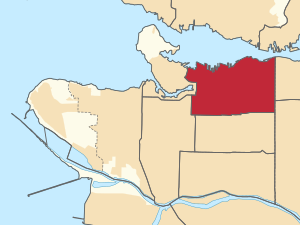
Country:
 Canada
Region:
City:
Latitude and Longitude:
Time Zone:
Postal Code:
IP information under different IP Channel
ip-api
Country
Region
City
ASN
Time Zone
ISP
Blacklist
Proxy
Latitude
Longitude
Postal
Route
IPinfo
Country
Region
City
ASN
Time Zone
ISP
Blacklist
Proxy
Latitude
Longitude
Postal
Route
MaxMind
Country
Region
City
ASN
Time Zone
ISP
Blacklist
Proxy
Latitude
Longitude
Postal
Route
Luminati
Country
CARegion
bc
City
northvancouver
ASN
Time Zone
America/Vancouver
ISP
OXIO-ASN-01
Latitude
Longitude
Postal
db-ip
Country
Region
City
ASN
Time Zone
ISP
Blacklist
Proxy
Latitude
Longitude
Postal
Route
ipdata
Country
Region
City
ASN
Time Zone
ISP
Blacklist
Proxy
Latitude
Longitude
Postal
Route
Popular places and events near this IP address
Vancouver East (federal electoral district)
Federal electoral district in British Columbia, Canada
Distance: Approx. 697 meters
Latitude and longitude: 49.272,-123.073
Vancouver East (French: Vancouver-Est) is a federal electoral district in British Columbia, Canada, that has been represented in the House of Commons of Canada since 1935. It is currently represented by New Democratic Party MP Jenny Kwan. The riding of Vancouver East is the poorest in Canada with a median individual income of $24,374 (2010).

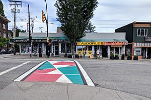
Little Italy, Vancouver
Area in Vancouver in British Columbia, Canada
Distance: Approx. 863 meters
Latitude and longitude: 49.26963,-123.06966
Little Italy is an area in the eastern part of Vancouver, British Columbia, Canada. It is in the Grandview–Woodland neighbourhood, and is often synonymous with the Commercial Drive area. Historically this area was an enclave of ethnic Italians and Italian businesses.

Spartacus Books
Bookstore in Vancouver, British Columbia, Canada
Distance: Approx. 1156 meters
Latitude and longitude: 49.2670511,-123.0704314
Spartacus Books is a non-profit, volunteer and collectively run bookstore and resource centre in Vancouver, British Columbia, Canada. It was founded in 1973. Spartacus sells new and used books, zines, comics, magazines, CDs, videos, T-shirts, patches, pins, posters and cards.
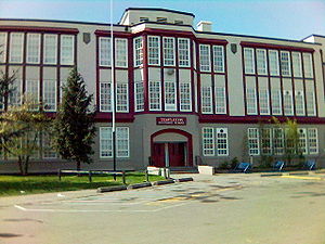
Templeton Secondary School
Secondary school in Vancouver, British Columbia, Canada
Distance: Approx. 521 meters
Latitude and longitude: 49.278,-123.0608
Templeton Secondary School is a public secondary school located in the Grandview-Woodland neighbourhood on the East Vancouver, British Columbia, Canada. Its student teams won the SmartAsk competition in 2004, the junior Reach For The Top provincial championships in 2015 and finished 3rd at the senior provincial Reach For The Top championships in 2017. The team ranked 6th at the 2017 National tournament.

Strathcona, Vancouver
Neighbourhood in Vancouver, Metro Vancouver
Distance: Approx. 1439 meters
Latitude and longitude: 49.27916667,-123.0875
Strathcona is the oldest residential neighbourhood of Vancouver, British Columbia, Canada. Officially a part of the East Side, it is bordered by Downtown Vancouver's Chinatown neighbourhood and the False Creek inlet (across Main Street) to the west, Downtown Eastside (across Hastings Street) to the north, Grandview-Woodland (across Clark Drive) to the east, and Mount Pleasant to the south of Emily Carr University and the Canadian National Railway and Great Northern Railway (now BNSF Railway) classification yards. By some definitions, Strathcona's northern border is the roads just south of Burrard Inlet, and much of the Downtown Eastside lies within Strathcona.
Port of Vancouver (1964–2008)
Port in Canada
Distance: Approx. 1285 meters
Latitude and longitude: 49.2854,-123.0805
The Port of Vancouver was a port located in and round Vancouver. It was the largest port in Canada, the largest in the Pacific Northwest, and the largest port on the West Coast of North America by metric tons of total cargo, with 76.5 million metric tons. The port amalgamated with the Fraser River Port Authority and the North Fraser Port Authority in 2008 to form Port Metro Vancouver, which has now adopted the Port of Vancouver name.
Grandview–Woodland
Neighbourhood in Lower Mainland, British Columbia, Canada
Distance: Approx. 264 meters
Latitude and longitude: 49.275,-123.067
Grandview–Woodland, also commonly known as Grandview–Woodlands, is a neighbourhood in Vancouver, British Columbia, Canada to the east of the downtown area, stretching south from the shores of Burrard Inlet and encompassing portions of the popular Commercial Drive area. It is a mature neighbourhood in Vancouver that is a vibrant mixture of commercial, industrial, single-family and multi-family residential with a rich ethnic history and features. A central part of the Vancouver area, Grandview–Woodland runs from the south shore of busy Burrard Inlet south to Broadway, one of the city's major east–west roads.
Britannia Secondary School
High school in Vancouver, British Columbia, Canada
Distance: Approx. 285 meters
Latitude and longitude: 49.276203,-123.07145
Britannia Community Secondary School is a public community secondary school located in the Grandview–Woodland neighbourhood on the east-side of Vancouver, British Columbia. The school educates its students using a district-wide block schedule program that alternates four blocks every two days. Students are subject to eight different blocks in total.
Frances Street Squats
1990 squatted project in Vancouver, Canada
Distance: Approx. 234 meters
Latitude and longitude: 49.2794,-123.0681
The Frances Street Squats were a set of six squatted houses, including one women-only building, that existed between February and November 1990 in Vancouver, Canada. They were occupied by SAVE (Squatters Alliance of Vancouver East) and took a stand against development which was generally supported by local people. The Vancouver Police Department evicted the buildings.

Hotel at the Waldorf
Boutique hotel in Vancouver, Canada
Distance: Approx. 663 meters
Latitude and longitude: 49.28151,-123.07436
The Hotel at the Waldorf is a boutique hotel in Vancouver, British Columbia, Canada. The hotel was established in 1947 and was one of the most renowned tiki-themed hotels in North America. In 2010, Thomas Anselmi and Ernesto Gomez took over operations and the hotel was renovated into a boutique hotel.
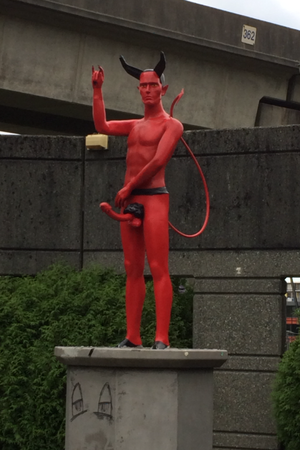
Penis Satan
Former statue in Vancouver, Canada
Distance: Approx. 1418 meters
Latitude and longitude: 49.266347,-123.0778735
Penis Satan, also called East Van Satan, was an unauthorized statue erected on September 9, 2014, in Vancouver, Canada. A life-size representation of a red devil with a large erect penis, making the sign of the horns hand gesture, the statue was erected in Clark Drive Plaza, an abandoned concrete amphitheater on the west side of Clark Drive at Grandview Highway North. It was made of mixed materials, including a modified mannequin, and was placed on an empty pedestal that previously displayed a three-foot-tall Christopher Columbus statue (honouring Angelo Branca).

Vanterm
Container terminal in Vancouver,
Distance: Approx. 1167 meters
Latitude and longitude: 49.287,-123.074
Vanterm is a container terminal in Vancouver, British Columbia, Canada. It is located on the south shore of the Burrard Inlet in Vancouver's East Side. It is operated by GCT Canada, a Vancouver-based company which also operates Deltaport another container terminal at the Port of Vancouver.
Weather in this IP's area
few clouds
17 Celsius
17 Celsius
15 Celsius
18 Celsius
1015 hPa
82 %
1015 hPa
1011 hPa
10000 meters
3.6 m/s
210 degree
20 %
06:53:52
19:18:39