Country:
Region:
City:
Latitude and Longitude:
Time Zone:
Postal Code:
IP information under different IP Channel
ip-api
Country
Region
City
ASN
Time Zone
ISP
Blacklist
Proxy
Latitude
Longitude
Postal
Route
Luminati
Country
Region
bc
City
newwestminster
ASN
Time Zone
America/Vancouver
ISP
OXIO-ASN-01
Latitude
Longitude
Postal
IPinfo
Country
Region
City
ASN
Time Zone
ISP
Blacklist
Proxy
Latitude
Longitude
Postal
Route
db-ip
Country
Region
City
ASN
Time Zone
ISP
Blacklist
Proxy
Latitude
Longitude
Postal
Route
ipdata
Country
Region
City
ASN
Time Zone
ISP
Blacklist
Proxy
Latitude
Longitude
Postal
Route
Popular places and events near this IP address

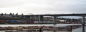
Queensborough Bridge
Bridge in New Westminster, British Columbia, Canada
Distance: Approx. 1133 meters
Latitude and longitude: 49.196415,-122.947183
Queensborough Bridge is a highway bridge in New Westminster, British Columbia. It was built in 1960 by John Laing and Son (Canada) for the City of New Westminster and cost $4 million (equivalent to $37.5 million in 2022). The bridge spans the north arm of the Fraser River for road access from the main part of New Westminster to the suburb of Queensborough at the east end of Lulu Island, giving the bridge its name.

New Westminster station
Metro Vancouver SkyTrain station
Distance: Approx. 1980 meters
Latitude and longitude: 49.201354,-122.912716
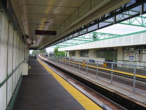
New Westminster is an elevated station on the Expo Line of Metro Vancouver's SkyTrain rapid transit system. The station is located at the intersection of Columbia Street and 8th Street in New Westminster, British Columbia. In 2012, the station was incorporated into the Shops at New West complex, making it the first train station in Canada to have a direct connection to a shopping centre at the platform level.
22nd Street station (SkyTrain)
Metro Vancouver SkyTrain station
Distance: Approx. 1500 meters
Latitude and longitude: 49.2,-122.94916667
22nd Street is an elevated station on the Expo Line of Metro Vancouver's SkyTrain rapid transit system. It is located on 7th Avenue and 22nd Street in the Connaught Heights neighbourhood of New Westminster, British Columbia, Canada. Due to its proximity to the Queensborough interchange, where the Queensborough Bridge meets with Stewardson and Marine Ways, the station serves as a hub for regional bus routes.

Annacis Island Swing Bridge
Bridge in New Westminster, Delta
Distance: Approx. 496 meters
Latitude and longitude: 49.18636,-122.932312
The Annacis Island Swing Bridge, built in 1986, is a road and rail swing bridge over the Annacis Channel of the Fraser River in the Lower Mainland of British Columbia, Canada. The bridge connects the community of Queensborough, part of New Westminster on Lulu Island, to Annacis Island in Delta. It replaced the Derwent Way Bridge built in 1955 at the same location.

Queensborough, New Westminster
Neighbourhood of New Westminster in Lower Mainland, British Columbia, Canada
Distance: Approx. 813 meters
Latitude and longitude: 49.18333333,-122.93333333
Queensborough is a neighbourhood in the city of New Westminster, British Columbia, Canada. It is on the eastern tip of Lulu Island on the Fraser River. At the north end of Queensborough is a new development called Port Royal.
Canadian Lacrosse Hall of Fame
Lacrosse hall of fame in British Columbia, Canada
Distance: Approx. 2067 meters
Latitude and longitude: 49.2015,-122.9114
The Canadian Lacrosse Hall of Fame is a Canadian lacrosse hall of fame, located in New Westminster, British Columbia, Canada. The Hall was chartered in 1965 by the Canadian Lacrosse Association, and inducted its first class of hall of famers in the following year.

Poplar Island (British Columbia)
Uninhabited island in British Columbia, Canada
Distance: Approx. 1049 meters
Latitude and longitude: 49.2,-122.93333333
Poplar Island is an uninhabited island located at the east end of the northern arm of the Fraser River in the City of New Westminster, British Columbia. It is the last large undiked island in the Fraser River's North Arm.
VirtualSchoolBC
Distance: Approx. 1577 meters
Latitude and longitude: 49.2007,-122.9192
VirtualSchoolBC is an online school offering free secondary school courses to British Columbia residents. It is headquartered in Westminster, British Columbia, Canada. VirtualSchoolBC is a public school within School District 40 New Westminster.

Wait for Me, Daddy
WWII Era photo
Distance: Approx. 2038 meters
Latitude and longitude: 49.20122,-122.91158
Wait for Me, Daddy is a photo taken by Claude P. Dettloff on October 1, 1940, of The British Columbia Regiment (Duke of Connaught's Own Rifles) marching down Eighth Street at the Columbia Street intersection, New Westminster, British Columbia. While Dettloff was taking the photo, Warren "Whitey" Bernard ran away from his mother to his father, Private Jack Bernard. The picture received extensive exposure and was used in war-bond drives.

Holy Trinity Cathedral (New Westminster)
Church in British Columbia, Canada
Distance: Approx. 2478 meters
Latitude and longitude: 49.2045,-122.9078
Holy Trinity Cathedral is a cathedral of the Anglican Diocese of New Westminster in New Westminster, British Columbia. The parish was established in 1859, with its current building completed in 1902. It is the second-oldest parish in the Diocese of New Westminster by six months, the oldest being Saint John's Maple Ridge.

The Armoury
Drill Hall / armoury in New Westminster, British Columbia
Distance: Approx. 2459 meters
Latitude and longitude: 49.2072,-122.9121
The Armoury also called The Armouries is a Canadian Forces armoury located at 530 Queens Avenue (at the corner of 6th Street) in New Westminster, British Columbia and it is the oldest active wooden military structure in Canada. It is the home of The Royal Westminster Regiment, an infantry reserve regiment.
Shops at New West
Shopping mall in British Columbia, Canada
Distance: Approx. 1980 meters
Latitude and longitude: 49.201354,-122.912716
Shops at New West is a shopping centre in New Westminster, British Columbia, Canada. The complex is unique for its integration into New Westminster station, a SkyTrain station on Metro Vancouver's metropolitan rail system. The shopping centre opened on November 17, 2012 and is owned by First Capital Realty.
Weather in this IP's area
broken clouds
10 Celsius
10 Celsius
8 Celsius
12 Celsius
1019 hPa
82 %
1019 hPa
1019 hPa
10000 meters
3.6 m/s
110 degree
75 %
07:11:45
16:39:23
