Country:
 Canada
Region:
City:
Latitude and Longitude:
Time Zone:
Postal Code:
IP information under different IP Channel
ip-api
Country
Region
City
ASN
Time Zone
ISP
Blacklist
Proxy
Latitude
Longitude
Postal
Route
IPinfo
Country
Region
City
ASN
Time Zone
ISP
Blacklist
Proxy
Latitude
Longitude
Postal
Route
MaxMind
Country
Region
City
ASN
Time Zone
ISP
Blacklist
Proxy
Latitude
Longitude
Postal
Route
Luminati
Country
CARegion
bc
City
surrey
ASN
Time Zone
America/Vancouver
ISP
OXIO-ASN-01
Latitude
Longitude
Postal
db-ip
Country
Region
City
ASN
Time Zone
ISP
Blacklist
Proxy
Latitude
Longitude
Postal
Route
ipdata
Country
Region
City
ASN
Time Zone
ISP
Blacklist
Proxy
Latitude
Longitude
Postal
Route
Popular places and events near this IP address
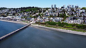
White Rock, British Columbia
City in British Columbia, Canada
Distance: Approx. 2083 meters
Latitude and longitude: 49.025,-122.80277778
White Rock is a city in British Columbia, Canada, and a member municipality of the Metro Vancouver Regional District. It is bordered by Semiahmoo Bay to the south and is surrounded on three sides by Surrey. To the southeast across a footbridge lies the Semiahmoo First Nation, which is within the borders of Surrey.
Surrey—White Rock—South Langley
Federal electoral district in British Columbia, Canada
Distance: Approx. 2442 meters
Latitude and longitude: 49.01991667,-122.80261111
Surrey—White Rock—South Langley (formerly known as Surrey—White Rock, South Surrey—White Rock and Surrey) was a federal electoral district in British Columbia, Canada, that was represented in the House of Commons of Canada from 1968 to 1979 and from 1988 to 1997.

Semiahmoo Shopping Centre
Shopping mall in British Columbia, Canada
Distance: Approx. 1820 meters
Latitude and longitude: 49.0326,-122.80223
Semiahmoo Shopping Centre ( SEH-mee-AH-moo) is an indoor shopping mall on the Semiahmoo peninsula in Surrey, British Columbia, Canada. Opened in 1980, the shopping centre is named after the nearby Semiahmoo Bay and is currently anchored by Save-On-Foods and Winners.
Earl Marriott Secondary School
High school in Surrey, British Columbia, Canada
Distance: Approx. 3042 meters
Latitude and longitude: 49.03166667,-122.78552778
Earl Marriott Secondary (EMS) is a public high school in the Vancouver suburb of Surrey, British Columbia, Canada and is part of School District 36 Surrey. It is referred to as the 'Home of the Mariners'. It is located on the edge of city limits, on 16th Avenue (which straddles the border between Surrey and White Rock).

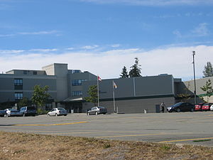
Semiahmoo Secondary School
Public school in Surrey, British Columbia, Canada
Distance: Approx. 968 meters
Latitude and longitude: 49.0349,-122.81364
Semiahmoo Secondary School ( SEM-ee-AM-moo) is a public high school in South Surrey, British Columbia, and is part of School District 36 Surrey. It was founded in 1940 as the first senior secondary school in South Surrey. The school serves grades eight through twelve.
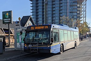
White Rock Centre
Distance: Approx. 1931 meters
Latitude and longitude: 49.03111111,-122.80111111
White Rock Centre is an on-street bus exchange located on the border between White Rock and Surrey, British Columbia, Canada. It is the southernmost transit hub in the Metro Vancouver region and the nearest to the Canada–United States border. As part of the TransLink system, it has routes serving White Rock and South Surrey, including towards Vancouver via Bridgeport station in Richmond, as well as to Surrey City Centre, Newton, Guildford and Langley City.
White Rock Christian Academy
Private school in Canada
Distance: Approx. 2088 meters
Latitude and longitude: 49.04327,-122.80122
White Rock Christian Academy (WRCA) is a Pre-K to Grade 12 Christian private school in South Surrey, British Columbia, Canada. WRCA states its core purpose is to "inspire and cultivate citizens of Godly character who transformed their world for Christ".
Ocean Park, Surrey
Neighborhood in British Columbia, Canada
Distance: Approx. 3367 meters
Latitude and longitude: 49.02666667,-122.87125
Ocean Park is a neighbourhood of South Surrey, a region of Surrey, British Columbia.
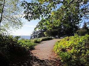
South Surrey Athletic Park
Distance: Approx. 1056 meters
Latitude and longitude: 49.04083,-122.81549
South Surrey Athletic Park is a popular recreational park in the White Rock/South Surrey community. The park is bound by 18th avenue to the south, 148th street to the east, 24th avenue to the North and Sunnyside Urban Acres Forest to the west. The park has three baseball diamonds, an indoor baseball training facility, tennis and volleyball courts, a number of grass and artificial turf soccer fields and an outdoor red urethane oval track.
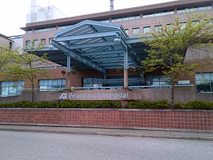
Peace Arch Hospital
Hospital in British Columbia, Canada
Distance: Approx. 2492 meters
Latitude and longitude: 49.029955,-122.793632
Peace Arch Hospital (PAH) is a 146-bed acute care facility, and Level IV trauma centre owned and operated by Fraser Health. The hospital is located at 15521 Russell Avenue, White Rock, British Columbia, Canada, and its catchment area includes South Surrey.

Elgin Park Secondary School
High school in Surrey, British Columbia, Canada
Distance: Approx. 1916 meters
Latitude and longitude: 49.04477,-122.84851
Elgin Park Secondary is a public high school in School District 36 Surrey, British Columbia, Canada. It is referred to as the "Home of the Orcas". Elgin Park is one of four public high schools on the peninsula, along with Earl Marriott Secondary School, Semiahmoo Secondary School, and Grandview Heights Secondary School.

Sunnyside, Surrey
Neighbourhood in Lower Mainland, British Columbia, Canada
Distance: Approx. 1340 meters
Latitude and longitude: 49.045,-122.81666667
Sunnyside is a neighbourhood of South Surrey, which in turn is a region of Surrey, British Columbia, Canada.
Weather in this IP's area
few clouds
16 Celsius
15 Celsius
14 Celsius
17 Celsius
1015 hPa
86 %
1015 hPa
1004 hPa
10000 meters
1.03 m/s
240 degree
12 %
06:52:59
19:17:36