Country:
 Canada
Region:
City:
Latitude and Longitude:
Time Zone:
Postal Code:
IP information under different IP Channel
ip-api
Country
Region
City
ASN
Time Zone
ISP
Blacklist
Proxy
Latitude
Longitude
Postal
Route
IPinfo
Country
Region
City
ASN
Time Zone
ISP
Blacklist
Proxy
Latitude
Longitude
Postal
Route
MaxMind
Country
Region
City
ASN
Time Zone
ISP
Blacklist
Proxy
Latitude
Longitude
Postal
Route
Luminati
Country
CARegion
bc
City
chilliwack
ASN
Time Zone
America/Vancouver
ISP
OXIO-ASN-01
Latitude
Longitude
Postal
db-ip
Country
Region
City
ASN
Time Zone
ISP
Blacklist
Proxy
Latitude
Longitude
Postal
Route
ipdata
Country
Region
City
ASN
Time Zone
ISP
Blacklist
Proxy
Latitude
Longitude
Postal
Route
Popular places and events near this IP address

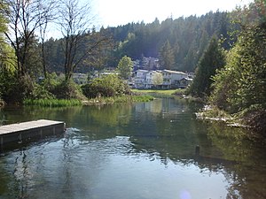
Cultus Lake, British Columbia
Lake in Canada
Distance: Approx. 2379 meters
Latitude and longitude: 49.0533,-121.9867
Cultus Lake is a lake, associated community and provincial park in the Fraser Valley region of British Columbia, Canada. It is the source of the Sweltzer River. Cultus Lake is located 11 kilometres (6.8 mi) south of the Chilliwack River, near the city of Chilliwack and approximately 80 kilometres (50 mi) east of Vancouver.

CFB Chilliwack
Former Canadian Forces base in British Columbia, Canada
Distance: Approx. 3501 meters
Latitude and longitude: 49.10315278,-121.96279167
Canadian Forces Base Chilliwack (also CFB Chilliwack) was a Canadian Forces base located in Chilliwack, British Columbia.
Vedder Mountain
Distance: Approx. 2319 meters
Latitude and longitude: 49.0664,-122.0119
The Vedder Mountain is a branch of the Cascade Range in the Pacific Northwest, located at the southeastern edge of the Fraser Lowland in British Columbia, Canada, between the village of Yarrow and the village of Cultus Lake, extending from the Vedder River to the Saar Creek valley. It separates the broad Fraser Valley and Sumas Prairie in its northwest from the narrow Columbia Valley to its southeast. The mountain stands 924 m (3,031 ft) high and is tree-covered to its summit with some open areas.
Area Support Unit Chilliwack
Canadian Armed Forces facility in Chilliwack, British Columbia
Distance: Approx. 2978 meters
Latitude and longitude: 49.101,-121.977
Area Support Unit Chilliwack (ASU Chilliwack) is a Canadian Forces facility located in Chilliwack, British Columbia. Located in the upper valley of the Fraser River, approximately 100 km (62 mi) east of Vancouver, it is the only Land Force Command facility in the province. It provides essential support and services for 200 Regular Force and 1800 Reserve Force personnel.
G.W. Graham Middle-Secondary School
High school in Chilliwack, British Columbia, Canada
Distance: Approx. 4241 meters
Latitude and longitude: 49.1073,-121.953
G.W Graham Secondary School, previously G.W Graham Middle-Secondary School, is a high school for students from grade 9 (age 14–15) to grade 12 (age 17–18) in Chilliwack, British Columbia. It is part of School District 33 Chilliwack. Prior to the school district reorganisation in 2018 this was constituted as a combined middle secondary school taking pupils from grade 7 (age 12–13).
Sweltzer River
River in British Columbia, Canada
Distance: Approx. 2847 meters
Latitude and longitude: 49.09694444,-121.96388889
The Sweltzer River is a river in British Columbia, Canada, that drains the waters of Cultus Lake into the Chilliwack River. It is about 3 kilometres (2 mi) long, and much of it runs through Soowahlie Indian Reserve No. 14, which is under the administration of the Soowahlie Indian Band.
Dinotown
Defunct theme park in British Columbia
Distance: Approx. 685 meters
Latitude and longitude: 49.07419,-121.97322
Dinotown was a dinosaur theme park in British Columbia, Canada, which operated from 1975 to 2010. Originally located in the lower Cultus Lake area and close to Bridal Falls in Chilliwack, B.C., Canada, it opened under the name Bedrock City and based around The Flintstones licensing. It reopened in 1995 under non-licensed dinosaur theming, and closed in 2010.
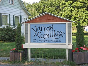
Yarrow Ecovillage
Distance: Approx. 5184 meters
Latitude and longitude: 49.081,-122.053
The Yarrow Ecovillage is an intentional community in Yarrow, British Columbia, Canada. Yarrow is a settlement of 3,000 population within the municipal boundaries of Chilliwack, British Columbia. The Ecovillage is a member-designed community that aims to achieve a more socially, ecologically and economically sustainable way of life.
Lindell Beach, British Columbia
Distance: Approx. 5213 meters
Latitude and longitude: 49.03333333,-122.01666667
Lindell Beach is a rural farming village in the Columbia Valley of the Lower Mainland region of the province of British Columbia, Canada, lying south of the City of Chilliwack. It is located at the south end of Cultus Lake which is the main waterbody in the Columbia Valley in the South Fraser Valley, and just north of the boundary of the United States. From 2014 to 2019 the area has seen a significant increase in population due to several gated community developments.

Canada Education Park
Distance: Approx. 3501 meters
Latitude and longitude: 49.10315278,-121.96279167
Canada Education Park (CEP) is located on the southside of Chilliwack at the former site of the Canadian army base called CFB Chilliwack. It is home to learning institutions including University of the Fraser Valley, Justice Institute of BC, and RCMP Pacific Region Training Centre.
Vedder Crossing, Chilliwack
Neighbourhood in Chilliwack in Canada, British Columbia
Distance: Approx. 3067 meters
Latitude and longitude: 49.1,-121.96666667
Vedder Crossing is adjacent to the junction of the Chilliwack and Vedder Rivers at its southern boundary, and Promontory Road to the north.
Cultus Lake Waterpark
Water park in British Columbia
Distance: Approx. 630 meters
Latitude and longitude: 49.07634,-121.97443
Cultus Lake Waterpark is one of the three amusement parks operated by Destination Cultus in Cultus Lake, British Columbia, with the others being Cultus Lake Adventure Park and Splashdown Vernon. It claims to be the largest water park in the province, at 640 acres (260 hectares).
Weather in this IP's area
overcast clouds
17 Celsius
17 Celsius
15 Celsius
18 Celsius
1015 hPa
80 %
1015 hPa
1007 hPa
10000 meters
0.61 m/s
0.88 m/s
244 degree
99 %
06:49:36
19:14:15