Country:
 Canada
Region:
City:
Latitude and Longitude:
Time Zone:
Postal Code:
IP information under different IP Channel
ip-api
Country
Region
City
ASN
Time Zone
ISP
Blacklist
Proxy
Latitude
Longitude
Postal
Route
IPinfo
Country
Region
City
ASN
Time Zone
ISP
Blacklist
Proxy
Latitude
Longitude
Postal
Route
MaxMind
Country
Region
City
ASN
Time Zone
ISP
Blacklist
Proxy
Latitude
Longitude
Postal
Route
Luminati
Country
CARegion
bc
City
vancouver
ASN
Time Zone
America/Vancouver
ISP
OXIO-ASN-01
Latitude
Longitude
Postal
db-ip
Country
Region
City
ASN
Time Zone
ISP
Blacklist
Proxy
Latitude
Longitude
Postal
Route
ipdata
Country
Region
City
ASN
Time Zone
ISP
Blacklist
Proxy
Latitude
Longitude
Postal
Route
Popular places and events near this IP address
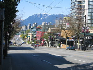
South Granville, Vancouver
Neighbourhood in Vancouver, British Columbia, Canada
Distance: Approx. 2082 meters
Latitude and longitude: 49.2342,-123.142
Established in 1997, South Granville (or less commonly "Uptown") is an upscale Business Improvement Area (BIA) and neighbourhood south of Vancouver's downtown core, centred along Granville Street and bordered by the neighbourhoods of Kitsilano, Fairview and Shaughnessy. Separated from Downtown by False Creek, the area runs along Granville Street from the south side of the Granville Street Bridge up to 16th Ave, where storefronts are replaced by the residences and hedges of Shaughnessy. 1907 has been decided as the unofficial birth year of the neighbourhood.

Kerrisdale
Neighborhood in Vancouver, BC, Canada
Distance: Approx. 1518 meters
Latitude and longitude: 49.2236,-123.1595
Kerrisdale is a neighbourhood in the city of Vancouver, British Columbia, Canada. Kerrisdale is a neighbourhood located in Vancouver's west side. It features a mix of newer houses and older bungalows as well as various low and mid-rise rental and condo apartment buildings in its northern section.
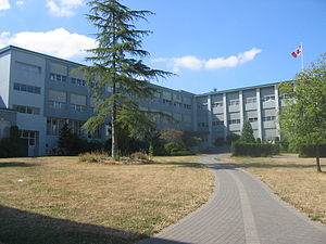
Sir Winston Churchill Secondary School (Vancouver)
Secondary school in Vancouver, British Columbia, Canada
Distance: Approx. 1454 meters
Latitude and longitude: 49.22083333,-123.12444444
Sir Winston Churchill Secondary School is a public secondary school located in Vancouver, British Columbia. Churchill Secondary is one of three International Baccalaureate schools (along with Britannia Secondary School and King George Secondary School) and one of three French immersion secondary schools in Vancouver. It is named after Winston Churchill, the former prime minister of the United Kingdom.

Arthur Laing Bridge
Bridge in Richmond, Vancouver
Distance: Approx. 1870 meters
Latitude and longitude: 49.199317,-123.135817
The Arthur Laing Bridge is a crossing over the north arm of the Fraser River, and several minor roads, in Metro Vancouver. Connecting Grant McConachie Way with SW Marine Drive, the bridge is 1,676 metres (5,499 ft) long and 20 metres (66 ft) wide, with a 270-metre (890 ft) main span standing 20 metres (66 ft) above the river. The main span comprises haunched (deeper at supports) steel box-girders and the approaches are concrete box-girders.

Magee Secondary School
Secondary school in Vancouver, British Columbia, Canada
Distance: Approx. 1648 meters
Latitude and longitude: 49.229,-123.152
Magee Secondary School is a public secondary school on West 49th Avenue, Vancouver, British Columbia, Canada. It is one of the first public high schools located in the Kerrisdale neighbourhood and is fed by the surrounding elementary schools in its catchment area. They include Maple Grove Elementary School, Dr.

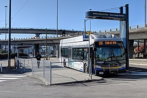
Marine Drive station
Metro Vancouver SkyTrain station
Distance: Approx. 1980 meters
Latitude and longitude: 49.20972222,-123.11694444
Marine Drive is an elevated station on the Canada Line of Metro Vancouver's SkyTrain rapid transit system. The station is located at the intersection of Cambie Street and SW Marine Drive in Vancouver, British Columbia.

Ideal Mini School
Secondary school (mini school) school in Vancouver, British Columbia, Canada
Distance: Approx. 1266 meters
Latitude and longitude: 49.217334,-123.125518
Ideal Mini School is a public secondary mini school in Vancouver, British Columbia. It is a complete grade 8–12 high school program. It is generally accepted as the "steward school" of Sir Winston Churchill Secondary, although it is run independently under the leadership of head teacher Sandra Hatzisavva.
Marpole Loop
Distance: Approx. 1546 meters
Latitude and longitude: 49.20277778,-123.13416667
Marpole Loop is a public transit exchange in the Marpole neighbourhood of Vancouver, British Columbia, Canada. This facility is part of Metro Vancouver's TransLink transit network. Located at the northern foot of the Arthur Laing Bridge, this is the southernmost exchange within the city of Vancouver.
George Pearson Centre
Hospital in B.C., Canada
Distance: Approx. 1628 meters
Latitude and longitude: 49.219041,-123.120972
George Pearson Centre is a long term residential care facility located in the Marpole neighbourhood of Vancouver, British Columbia, and is currently owned and operated by Vancouver Coastal Health. George Pearson Centre was named after former BC Minister of Health, George S. Pearson. Built in 1952 to originally treat tuberculosis patients and then polio patients, in the 1960s the focus of George Pearson Centre changed to long term care for adults with disabilities.

Marpole Midden
Midden pile in British columbia
Distance: Approx. 1314 meters
Latitude and longitude: 49.204,-123.1386
The Marpole Midden, also known by archaeologists as the Great Fraser Midden or Eburne site, is a 4000-year-old midden near the mouth of the Fraser River, in the Marpole neighbourhood of Vancouver, British Columbia. The site was the location of the ancient Musqueam village of c̓əsnaʔəm and a sacred burial ground.
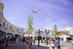
McArthurGlen Designer Outlet Vancouver Airport
Shopping mall in British Columbia, Canada
Distance: Approx. 2010 meters
Latitude and longitude: 49.1975,-123.14055556
McArthurGlen Designer Outlet Vancouver Airport (commonly known as McArthurGlen Vancouver) is an outlet mall on Sea Island in Richmond, British Columbia. It is located in close proximity to Vancouver International Airport. It currently has around 80 retailers over 340,000 square feet.
Marpole Bridge (1889)
Bridge in Marpole-Richmond
Distance: Approx. 2040 meters
Latitude and longitude: 49.197828,-123.13525
The Marpole Bridge (1889–1957), a.k.a. Eburne Bridge, North Arm Bridge, Sea Island Bridge, or Middle Arm Bridge, was consecutive crossings over the north and middle arms of the Fraser River in Metro Vancouver.
Weather in this IP's area
few clouds
16 Celsius
16 Celsius
15 Celsius
18 Celsius
1015 hPa
83 %
1015 hPa
1009 hPa
10000 meters
3.6 m/s
210 degree
20 %
06:54:11
19:18:56