Country:
 Canada
Region:
City:
Latitude and Longitude:
Time Zone:
Postal Code:
IP information under different IP Channel
ip-api
Country
Region
City
ASN
Time Zone
ISP
Blacklist
Proxy
Latitude
Longitude
Postal
Route
IPinfo
Country
Region
City
ASN
Time Zone
ISP
Blacklist
Proxy
Latitude
Longitude
Postal
Route
MaxMind
Country
Region
City
ASN
Time Zone
ISP
Blacklist
Proxy
Latitude
Longitude
Postal
Route
Luminati
Country
CARegion
bc
City
portcoquitlam
ASN
Time Zone
America/Vancouver
ISP
OXIO-ASN-01
Latitude
Longitude
Postal
db-ip
Country
Region
City
ASN
Time Zone
ISP
Blacklist
Proxy
Latitude
Longitude
Postal
Route
ipdata
Country
Region
City
ASN
Time Zone
ISP
Blacklist
Proxy
Latitude
Longitude
Postal
Route
Popular places and events near this IP address

Port Coquitlam
City in British Columbia, Canada
Distance: Approx. 1836 meters
Latitude and longitude: 49.2625,-122.78111111
Port Coquitlam ( koh-KWIT-ləm) is a city in British Columbia, Canada. It is one of 21 municipalities comprising Metro Vancouver. Located 27 km (17 mi) east of Vancouver, it is on the north bank of the confluence of the Fraser River and the Pitt River.
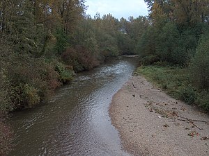
Coquitlam River
River in British Columbia, Canada
Distance: Approx. 2751 meters
Latitude and longitude: 49.225,-122.805
The Coquitlam River (/koʊˈkwɪtləm/ or /kəˈkwɪtləm/) is a tributary of the Fraser River in the Canadian province of British Columbia. The river's name comes from the word Kʷikʷəƛ̓əm which translates to "Red fish up the river". The name is a reference to a sockeye salmon species that once occupied the river's waters.

Pitt River
River in British Columbia, Canada
Distance: Approx. 3022 meters
Latitude and longitude: 49.22861111,-122.76777778
The Pitt River in British Columbia, Canada is a large tributary of the Fraser River, entering it a few miles upstream from New Westminster and about 25 km ESE of Downtown Vancouver. The river, which begins in the Garibaldi Ranges of the Coast Mountains, is in two sections above and below Pitt Lake and flows on a generally southernly course. Pitt Lake and the lower Pitt River are tidal in nature as the Fraser's mouth is only a few miles downstream from their confluence.

Riverside Secondary School (British Columbia)
Public secondary school in Port Coquitlam, British Columbia, Canada
Distance: Approx. 922 meters
Latitude and longitude: 49.25611111,-122.78916667
Riverside Secondary School is a public coeducational secondary school located in Port Coquitlam, British Columbia, Canada. It enrolls approximately 1470 students from grades 9 to 12.

Tri-Cities (British Columbia)
Geographical grouping in Metro Vancouver
Distance: Approx. 2163 meters
Latitude and longitude: 49.26666667,-122.78333333
The Tri-Cities are an informal grouping of the three adjacent suburban cities of Coquitlam, Port Coquitlam, and Port Moody, along with the two villages of Anmore and Belcarra in the northeast sector of Metro Vancouver in British Columbia. Combined, these five communities had a population of 246,701 residents in 2021.
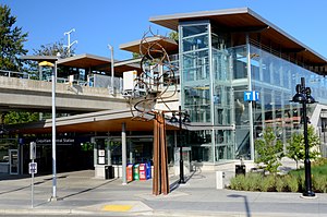
Coquitlam Central station
Metro Vancouver public transportation station
Distance: Approx. 2802 meters
Latitude and longitude: 49.27388889,-122.8
Coquitlam Central station is an intermodal rapid transit station in Metro Vancouver served by both the Millennium Line—part of the SkyTrain system—and the region's West Coast Express commuter rail system. The station is located on the north side of the Canadian Pacific Railway (CPR) tracks in Coquitlam, just west of the Lougheed Highway rail overpass, near the Coquitlam Centre shopping mall. 601 parking spaces are available on site.
Dr. Charles Best Secondary School
Co-educational public secondary school in Coquitlam, British Columbia, Canada
Distance: Approx. 2566 meters
Latitude and longitude: 49.26388889,-122.82222222
Dr. Charles Best Secondary School is a co-educational public high school located in Coquitlam, British Columbia. The school is named for Canadian physician Charles Best, one of the researchers responsible for the discovery of insulin as a treatment for diabetes.

Port Coquitlam station
Metro Vancouver commuter rail station
Distance: Approx. 2092 meters
Latitude and longitude: 49.26138889,-122.77388889
Port Coquitlam is a station on the West Coast Express commuter rail line connecting Vancouver to Mission, British Columbia, Canada. The station is located on the south side of the Canadian Pacific Railway (CPR) tracks in Port Coquitlam, just off Kingsway Avenue. The station opened in 1995, when the West Coast Express began operating.
Mundy Park
Park in Coquitlam, British Columbia
Distance: Approx. 2363 meters
Latitude and longitude: 49.2561,-122.826
Mundy Park is a park located in Coquitlam, British Columbia, Canada. At 176 hectares (435 acres), it is the largest park Coquitlam. The park has many walking trails that pass the park's two lakes: Mundy Lake and Lost Lake.
Coast Meridian Overpass
Bridge in Port Coquitlam
Distance: Approx. 2884 meters
Latitude and longitude: 49.25739,-122.757905
The Coast Meridian Overpass is a four-lane cable stayed bridge in Port Coquitlam, British Columbia, crossing the Canadian Pacific railyard. It is 25 metres wide and 580 m long, with a bike lane on the northbound side and a separated pedestrian walkway on the southbound side of the overpass. The construction project, officially launched in 2008, links Coast Meridian Road and Lougheed Highway on the north with Kingsway Avenue and Broadway Street on the south.

Riverview Hospital (Coquitlam)
Former mental health facility in British Columbia, Canada
Distance: Approx. 786 meters
Latitude and longitude: 49.246544,-122.805602
Riverview Hospital was a Canadian mental health facility located in Coquitlam, British Columbia. It operated under the governance of BC Mental Health & Addiction Services until it closed, in July 2012. In December 2015, the provincial government announced plans to replace the obsolete buildings with new mental health facilities, scheduled to open in about 2019.

Colony Farm Regional Park
Park in Coquitlam, British Columbia, Canada
Distance: Approx. 1134 meters
Latitude and longitude: 49.24,-122.803
ƛ̓éxətəm Regional Park (tla-hut-um, formerly known as Colony Farm Regional Park), is a park along the Coquitlam River in the Tri-Cities area of Metro Vancouver. It is 260 hectares in size. Colony Farm was once one of the most modern and productive working farms in Canada.
Weather in this IP's area
broken clouds
17 Celsius
17 Celsius
16 Celsius
18 Celsius
1015 hPa
75 %
1015 hPa
1015 hPa
10000 meters
0.66 m/s
0.74 m/s
165 degree
84 %
06:52:47
19:17:34