Country:
 Canada
Region:
City:
Latitude and Longitude:
Time Zone:
Postal Code:
IP information under different IP Channel
ip-api
Country
Region
City
ASN
Time Zone
ISP
Blacklist
Proxy
Latitude
Longitude
Postal
Route
IPinfo
Country
Region
City
ASN
Time Zone
ISP
Blacklist
Proxy
Latitude
Longitude
Postal
Route
MaxMind
Country
Region
City
ASN
Time Zone
ISP
Blacklist
Proxy
Latitude
Longitude
Postal
Route
Luminati
Country
CARegion
bc
City
mapleridge
ASN
Time Zone
America/Vancouver
ISP
OXIO-ASN-01
Latitude
Longitude
Postal
db-ip
Country
Region
City
ASN
Time Zone
ISP
Blacklist
Proxy
Latitude
Longitude
Postal
Route
ipdata
Country
Region
City
ASN
Time Zone
ISP
Blacklist
Proxy
Latitude
Longitude
Postal
Route
Popular places and events near this IP address
Ruskin, British Columbia
Rural community in British Columbia, Canada
Distance: Approx. 4157 meters
Latitude and longitude: 49.2,-122.43333333
Ruskin is a rural, naturally-treed community, about 35 mi (56 km) east of Vancouver on the north shore of the Fraser River. It was named around 1900 after of the English art critic, essayist, and prominent social thinker John Ruskin. Ruskin is one of the historical communities of the municipality of Maple Ridge.
Fort Langley Water Aerodrome
Airport in Fort Langley, British Columbia
Distance: Approx. 5602 meters
Latitude and longitude: 49.16666667,-122.53333333
Fort Langley Water Aerodrome (TC LID: CAS4) is a private airport located adjacent to Fort Langley, British Columbia, Canada.

Garibaldi Secondary School
High school in Maple Ridge, British Columbia, Canada
Distance: Approx. 3755 meters
Latitude and longitude: 49.22154,-122.53643
Garibaldi Secondary School is a grade 8–12 school located in Maple Ridge, British Columbia, Canada. The school presently has about 1,040 students, and 62 teachers.
Meadowridge School
Independent school in St, Maple Ridge, British Columbia, Canada
Distance: Approx. 5063 meters
Latitude and longitude: 49.2242,-122.5542
Meadowridge School (also known as MDR), located in Maple Ridge, British Columbia, Canada, is a coeducational, independent school teaching Junior Kindergarten through to Grade 12. Although consistently placing within the top three schools according to the Fraser Report, Meadowridge School Headmaster has publicly denounced the Fraser Report rankings. Meadowridge School received the 2014 Maple Ridge Chamber of Commerce Business of the Year Award.
Albion, British Columbia
Distance: Approx. 5200 meters
Latitude and longitude: 49.18333333,-122.55
Albion, British Columbia is a neighbourhood in Maple Ridge, British Columbia and is one of several small towns incorporated within the municipality at its creation. It is the oldest non-indigenous community of the district's settlements, and is only slightly younger than Fort Langley, adjacent across the Fraser River, and Kanaka Creek, which is just to the west and lies along the creek of the same name. Its official definition is the area bounded by the Fraser River, Kanaka Way, and 240th Street, but in its historic sense it means the community centred on and flanking 240th Street and adjoining areas along the Fraser River waterfront and around the Maple Ridge Fairgrounds, while along Kanaka Way and also on the near bank of Kanaka Creek, the creek, is historically the community of Kanaka Creek.
Whonnock
Rural community in British Columbia, Canada
Distance: Approx. 4157 meters
Latitude and longitude: 49.2,-122.43333333
Whonnock is a rural, naturally treed, and hilly community on the north side of the Fraser River in the eastern part of the City of Maple Ridge, British Columbia, Canada. It is approximately 56 kilometres east of Downtown Vancouver on the Lougheed Highway Whonnock shares borders with three other Maple Ridge communities. To the west the borders are 256th Street with Albion and upper Kanaka Creek with Webster's Corners.

Kanaka Creek Regional Park
Regional park in British Columbia
Distance: Approx. 2599 meters
Latitude and longitude: 49.2106,-122.5247
Kanaka Creek Regional Park is a regional park of the Greater Vancouver Regional District, located in the city of Maple Ridge, British Columbia, flanking both sides of Kanaka Creek from its confluence with the Fraser River just east of Haney and extending approximately 11 km (7 mi) up the creek to just south of the community of Webster's Corners. The Maple Ridge Fairgrounds are just east of the lower regions of the park, beyond them is the community of Albion. Derby Reach Regional Park is just across the Fraser in Langley.
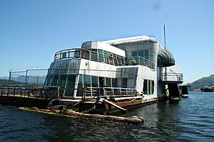
McBarge
Former McDonald's floating restaurant at Expo 86 in Vancouver
Distance: Approx. 6405 meters
Latitude and longitude: 49.184193,-122.56943
The McBarge, officially named the Friendship 500, is a former McDonald's restaurant, built on a 187-foot-long (57 m) barge for Expo '86 in Vancouver, British Columbia. Moored on Expo grounds in Vancouver's False Creek, it was the second floating McDonald's location in the world (the first being in St. Louis, Missouri), intended to showcase future technology and architecture.

Ruskin Dam and Powerhouse
Dam in Ruskin, British Columbia
Distance: Approx. 6092 meters
Latitude and longitude: 49.19583333,-122.4075
Ruskin Dam is a concrete gravity dam on the Stave River in Ruskin, British Columbia, Canada. The dam was completed in 1930 for the primary purpose of hydroelectric power generation. The dam created Hayward Lake, which supplies water to a 105 MW powerhouse and flooded the Stave's former lower canyon, which ended in a small waterfall approximately where the dam is today.
Webster's Corners
Community in British Columbia, Canada
Distance: Approx. 2223 meters
Latitude and longitude: 49.21666667,-122.51666667
Webster's Corners is a community in British Columbia, located northeast of Albion in Maple Ridge, British Columbia. Webster's Corners was founded by James Murray Webster who was born in Aberdeen, Scotland. James Webster arrived in 1883 and was the first postmaster.
Whonnock Lake
Natural muskeg lake in British Columbia, Canada
Distance: Approx. 3041 meters
Latitude and longitude: 49.21277778,-122.44805556
Whonnock Lake is a natural muskeg lake. If left alone, it will slowly turn into a peat marsh. The only regular water input is from the north.
Thornhill, Maple Ridge
Distance: Approx. 2974 meters
Latitude and longitude: 49.183,-122.504
The neighbourhood of Thornhill on the south slope of Grant Hill in Maple Ridge, British Columbia, Canada, forms the western part of the historical community of Whonnock. The lower part along the Fraser River attracted some early settlers, but the higher land only became populated after the First World War, when Japanese farmers were among the first to open its land for agriculture. After the Japanese were evicted in 1942, their lands became available to a growing community of young white families.
Weather in this IP's area
overcast clouds
16 Celsius
16 Celsius
14 Celsius
17 Celsius
1015 hPa
81 %
1015 hPa
1001 hPa
10000 meters
0.36 m/s
0.46 m/s
255 degree
89 %
06:51:34
19:16:19