Country:
 Canada
Region:
City:
Latitude and Longitude:
Time Zone:
Postal Code:
IP information under different IP Channel
ip-api
Country
Region
City
ASN
Time Zone
ISP
Blacklist
Proxy
Latitude
Longitude
Postal
Route
IPinfo
Country
Region
City
ASN
Time Zone
ISP
Blacklist
Proxy
Latitude
Longitude
Postal
Route
MaxMind
Country
Region
City
ASN
Time Zone
ISP
Blacklist
Proxy
Latitude
Longitude
Postal
Route
Luminati
Country
CARegion
bc
City
portcoquitlam
ASN
Time Zone
America/Vancouver
ISP
OXIO-ASN-01
Latitude
Longitude
Postal
db-ip
Country
Region
City
ASN
Time Zone
ISP
Blacklist
Proxy
Latitude
Longitude
Postal
Route
ipdata
Country
Region
City
ASN
Time Zone
ISP
Blacklist
Proxy
Latitude
Longitude
Postal
Route
Popular places and events near this IP address

Maple Ridge, British Columbia
City in British Columbia, Canada
Distance: Approx. 1444 meters
Latitude and longitude: 49.21666667,-122.6
Maple Ridge is a city in British Columbia, Canada. It is located in the northeastern section of Greater Vancouver between the Fraser River and the Golden Ears, which is a group of mountain summits which are the southernmost of the Garibaldi Ranges of the Coast Mountains. Maple Ridge's population in 2021 was 90,990.
Arthur Peake Centre
School in British Columbia, Canada
Distance: Approx. 2919 meters
Latitude and longitude: 49.213101,-122.580333
Arthur Peake Centre (Connex) is an alternate secondary school in Maple Ridge part of School District 42 Maple Ridge-Pitt Meadows. It is located on 116th Ave., across from Thomas Haney Secondary School.
Maple Ridge Secondary School
High school in Maple Ridge, British Columbia, Canada
Distance: Approx. 401 meters
Latitude and longitude: 49.22501,-122.61508
Maple Ridge Secondary is a public high school in Maple Ridge, British Columbia, Canada, part of School District 42 Maple Ridge-Pitt Meadows.

Thomas Haney Secondary School
High school in Maple Ridge, British Columbia, Canada
Distance: Approx. 2881 meters
Latitude and longitude: 49.21191667,-122.58161111
Thomas Haney Secondary School is a self directed learning public high school in Maple Ridge, British Columbia, Canada, under the authority of School District 42 Maple Ridge-Pitt Meadows. Athletic organizations within the school are known as the Thomas Haney Thunder.
Westview Secondary School
Secondary School in British Columbia
Distance: Approx. 1755 meters
Latitude and longitude: 49.22408,-122.64203
Westview Secondary School is a public high school in Maple Ridge, British Columbia. It is part of School District 42 Maple Ridge-Pitt Meadows.
Haney, British Columbia
Human settlement in British Columbia, Canada
Distance: Approx. 1444 meters
Latitude and longitude: 49.21666667,-122.6
Haney, British Columbia is the name of the downtown core of the city of Maple Ridge, British Columbia. The name derived originally from Thomas Haney, the namesake of Port Haney, the neighbourhood adjoining today's downtown along the Fraser River immediately south, which is today includes a station on the West Coast Express and was formerly a steamboat port. Port Haney is a designated heritage district in Maple Ridge and includes buildings moved to the neighbourhood from other parts of the municipality that otherwise might have been demolished.
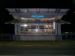
Port Haney station
Metro Vancouver commuter rail station
Distance: Approx. 1437 meters
Latitude and longitude: 49.21222222,-122.60519444
Port Haney station is a commuter rail station served by the West Coast Express line which connects Vancouver and Mission in British Columbia, Canada. The station is located on the north side of the Canadian Pacific Railway (CPR) tracks in Maple Ridge, just off River Road and 223rd Street. The station opened in 1995, when the West Coast Express began operating.
Kanaka Creek, British Columbia
Place in British Columbia, Canada
Distance: Approx. 3347 meters
Latitude and longitude: 49.20055556,-122.58583333
Kanaka Creek is an historic rural residential area located within Maple Ridge, British Columbia, Canada, along the banks of the creek of the same name just east of the district's main town and commercial core of Haney. Just east is Albion and immediately across the Fraser River is Derby or "Old Fort Langley", upstream from which and opposite Albion is Fort Langley. Kanaka Creek was settled by Hawaiian natives in the employ of the Hudson's Bay Company, known as Kanakas, often with local indigenous, usually Kwantlen, wives.
Derby, British Columbia
Place in British Columbia, Canada
Distance: Approx. 2688 meters
Latitude and longitude: 49.2,-122.63333333
Derby is a locality on the lower Fraser River in northwestern Langley. The site of the original Fort Langley, established in 1827 by the Hudson's Bay Company, and was the first post established in Coast Salish territory. The Fort was later moved 4 km to its present location in 1839.

Kanaka Creek
River in British Columbia, Canada
Distance: Approx. 3347 meters
Latitude and longitude: 49.20055556,-122.58583333
Kanaka Creek is a tributary of the Fraser River, in the Canadian province of British Columbia. It flows through Maple Ridge, a district municipality at the eastern edge of Metro Vancouver. The creek's name is reflected in the name of the local community of Kanaka Creek.
Port Hammond
Distance: Approx. 3373 meters
Latitude and longitude: 49.2,-122.65
Port Hammond, commonly known as Hammond, is a community on the Fraser River within the city of Maple Ridge, British Columbia, Canada, near its border with the City of Pitt Meadows and just east of the Golden Ears Bridge.
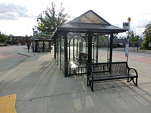
Haney Place Exchange
Transit exchange in British Columbia, Canada
Distance: Approx. 1553 meters
Latitude and longitude: 49.2195,-122.59709
Haney Place Exchange is a transit exchange in Maple Ridge, British Columbia, Canada. Opened on August 27, 2008, it is the easternmost major transit exchange in the Metro Vancouver area. Part of the TransLink system, it is home to routes serving Maple Ridge and Pitt Meadows, and routes to Coquitlam, the Township of Langley, and Braid station in New Westminster.
Weather in this IP's area
overcast clouds
17 Celsius
17 Celsius
15 Celsius
18 Celsius
1015 hPa
78 %
1015 hPa
1011 hPa
10000 meters
0.42 m/s
0.63 m/s
160 degree
89 %
06:52:05
19:16:50