Country:
 Canada
Region:
City:
Latitude and Longitude:
Time Zone:
Postal Code:
IP information under different IP Channel
ip-api
Country
Region
City
ASN
Time Zone
ISP
Blacklist
Proxy
Latitude
Longitude
Postal
Route
IPinfo
Country
Region
City
ASN
Time Zone
ISP
Blacklist
Proxy
Latitude
Longitude
Postal
Route
MaxMind
Country
Region
City
ASN
Time Zone
ISP
Blacklist
Proxy
Latitude
Longitude
Postal
Route
Luminati
Country
CARegion
bc
City
portcoquitlam
ASN
Time Zone
America/Vancouver
ISP
OXIO-ASN-01
Latitude
Longitude
Postal
db-ip
Country
Region
City
ASN
Time Zone
ISP
Blacklist
Proxy
Latitude
Longitude
Postal
Route
ipdata
Country
Region
City
ASN
Time Zone
ISP
Blacklist
Proxy
Latitude
Longitude
Postal
Route
Popular places and events near this IP address
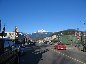
Squamish, British Columbia
Municipality in Canada
Distance: Approx. 496 meters
Latitude and longitude: 49.70166667,-123.15888889
Squamish (IPA: [skwɔːmɪʃ]; Squamish: Sḵwx̱wú7mesh, IPA: [ˈsqʷχʷuː.ʔməʃ]; 2021 census population 23,819) is a community and a district municipality in the Canadian province of British Columbia, located at the north end of Howe Sound on the Sea to Sky Highway. The population of the Squamish census agglomeration, which includes First Nation reserves of the Squamish Nation although they are not governed by the municipality, is 24,232. Indigenous Squamish people have lived in the area for thousands of years.
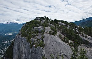
Stawamus Chief
Mountain in British Columbia, Canada
Distance: Approx. 1839 meters
Latitude and longitude: 49.68388889,-123.14166667
The Stawamus Chief, officially Stawamus Chief Mountain (often referred to as simply The Chief, or less commonly Squamish Chief), is a granitic dome located adjacent to the town of Squamish, British Columbia, Canada. It towers over 700 m (2,297 ft) above the waters of nearby Howe Sound. It is one of the largest granite monoliths in the world.
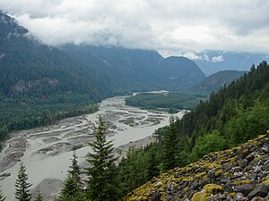
Squamish River
River in British Columbia, Canada
Distance: Approx. 2397 meters
Latitude and longitude: 49.68277778,-123.17888889
The Squamish River is a short but very large river in the Canadian province of British Columbia. Its drainage basin is 3,328 square kilometres (1,285 sq mi) in size. The total length of the Squamish River is approximately 80 kilometres (50 mi).
CISQ-FM
Radio station in Squamish–Whistler, British Columbia
Distance: Approx. 1893 meters
Latitude and longitude: 49.70833333,-123.13444444
CISQ-FM (107.1 MHz) is a radio station owned by Rogers Radio, a division of Rogers Sports & Media, and operating in southwestern British Columbia. It broadcasts at 107.1 MHz in Squamish and 102.1 MHz in Whistler.

Howe Sound Secondary School
High school in Squamish, British Columbia, Canada
Distance: Approx. 1040 meters
Latitude and longitude: 49.70687,-123.15117
Howe Sound Secondary is a public Secondary school in Squamish, British Columbia part of School District 48 Howe Sound. It is the largest school in the district, and is one of 2 schools in Squamish to offer grades 10–12.
The Castle (volcano)
Lava spine in British Columbia, Canada
Distance: Approx. 2656 meters
Latitude and longitude: 49.69,-123.19
The Castle is a lava spine located west of Squamish in southwestern British Columbia, Canada. Volcanism at The Castle is controlled by north–south structures and there are no hot springs known in the area. It forms part of the Monmouth Creek complex and is part of the Garibaldi Volcanic Belt which is a segment of the Cascade Volcanic Arc.
Stawamus River
River in British Columbia, Canada
Distance: Approx. 1066 meters
Latitude and longitude: 49.68833333,-123.15472222
The Stawamus River is a small, creek-like river in British Columbia. It enters the Howe Sound east of the mouth of the Squamish River.
Monmouth Creek complex
Distance: Approx. 3039 meters
Latitude and longitude: 49.69388889,-123.19694444
The Monmouth Creek complex is a volcanic complex in southwestern British Columbia, Canada, located 4 km (2.5 mi) southwest of the community of Squamish on the west side of the Squamish River mouth. It lies in the southern Pacific Ranges of the Coast Mountains and is part of the Squamish volcanic field in the southern Garibaldi Volcanic Belt, which represents the northernmost extension of the Cascade Volcanic Arc. Its prominent and enigmatic edifice is composed of basaltic andesite to dacite of unknown age and may represent a group of dikes and lava domes that formed subglacially.
Carbon Engineering
Canadian energy company
Distance: Approx. 1189 meters
Latitude and longitude: 49.6883,-123.16244
Carbon Engineering Ltd. is a Canadian-based clean energy company focusing on the commercialization of direct air capture (DAC) technology that captures carbon dioxide (CO2) directly from the atmosphere. This captured CO2 can either be stored underground, or converted into carbon-neutral fuel using renewable energy sources, by a process the company calls "air to fuels".
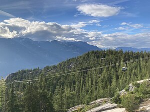
Sea to Sky Gondola
Gondola in British Columbia, Canada
Distance: Approx. 2521 meters
Latitude and longitude: 49.67527778,-123.15694444
The Sea to Sky Gondola is a privately owned recreational aerial tramway about 2 km (1.2 mi) south of Squamish, British Columbia. On BC-99, it offers views over Howe Sound along with cafes, a lodge, hiking trails, and a suspension bridge, the Sky Pilot Suspension Bridge. The majority of the area is located inside of Stawamus Chief Provincial Park.

Skwelwil'em Squamish Estuary Wildlife Management Area
Wildlife Management Area in British Columbia, Canada
Distance: Approx. 1969 meters
Latitude and longitude: 49.71277778,-123.17
The Skwelwil'em Squamish Estuary Wildlife Management Area is a wildlife management area on the south coast of British Columbia. It was established in 2007 for the management of fish species as well as terrestrial wildlife. The wildlife management area is on the traditional territory of Squamish Nation, which is involved in management of the area.

Cobra Crack
Traditional climbing route in Squamish, Canada
Distance: Approx. 1983 meters
Latitude and longitude: 49.68472222,-123.13666667
Cobra Crack is a 45-metre (148-foot) long traditional climbing route on a thin crack up an overhanging granite rock face on Stawamus Chief, in Squamish, British Columbia. The route was first ascended by Peter Croft and Tami Knight in 1981 as an aid climb. After it rebuffed many leading climbers, most notably Swiss climber Didier Berthod in 2005, the Canadian climber Sonnie Trotter made the first free ascent in 2006.
Weather in this IP's area
scattered clouds
18 Celsius
18 Celsius
17 Celsius
18 Celsius
1014 hPa
69 %
1014 hPa
1014 hPa
10000 meters
4.02 m/s
6.26 m/s
248 degree
45 %
06:54:04
19:19:10