Country:
 Canada
Region:
City:
Latitude and Longitude:
Time Zone:
Postal Code:
IP information under different IP Channel
ip-api
Country
Region
City
ASN
Time Zone
ISP
Blacklist
Proxy
Latitude
Longitude
Postal
Route
IPinfo
Country
Region
City
ASN
Time Zone
ISP
Blacklist
Proxy
Latitude
Longitude
Postal
Route
MaxMind
Country
Region
City
ASN
Time Zone
ISP
Blacklist
Proxy
Latitude
Longitude
Postal
Route
Luminati
Country
CARegion
bc
City
richmond
ASN
Time Zone
America/Vancouver
ISP
OXIO-ASN-01
Latitude
Longitude
Postal
db-ip
Country
Region
City
ASN
Time Zone
ISP
Blacklist
Proxy
Latitude
Longitude
Postal
Route
ipdata
Country
Region
City
ASN
Time Zone
ISP
Blacklist
Proxy
Latitude
Longitude
Postal
Route
Popular places and events near this IP address

Greater Vancouver
Metropolitan area in British Columbia, Canada
Distance: Approx. 934 meters
Latitude and longitude: 49.24944444,-122.97972222
Greater Vancouver, also known as Metro Vancouver, is the metropolitan area with its major urban centre being the city of Vancouver, British Columbia, Canada. The term "Greater Vancouver" describes an area that is roughly coterminous with the region governed by the Metro Vancouver Regional District (MVRD), though it predates the 1966 creation of the regional district. It is often used to include areas beyond the boundaries of the regional district but does not generally include wilderness and agricultural areas that are included within the MVRD. Usage of the term "Greater Vancouver" is not consistent.
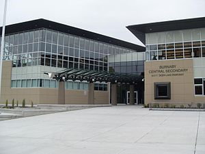
Burnaby Central Secondary School
High school in Burnaby, British Columbia, Canada
Distance: Approx. 1284 meters
Latitude and longitude: 49.24397222,-122.97513889
Burnaby Central Secondary School is a public high school in Burnaby, British Columbia. It is located across from Burnaby City Hall and is adjacent to Deer Lake Park. Burnaby Central is a part of Burnaby School District 41.
Moscrop Secondary School
High school in Burnaby, British Columbia, Canada
Distance: Approx. 986 meters
Latitude and longitude: 49.24357,-123.00448
Moscrop Secondary School is a publicly operated secondary school in Burnaby, British Columbia. The school serves grades eight through twelve and currently has an enrollment of about 1500 students. It is one of the three high schools in School District 41 to offer the French Immersion program.
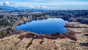
Deer Lake (British Columbia)
Distance: Approx. 1587 meters
Latitude and longitude: 49.236655,-122.977395
Deer Lake is a lake in central Burnaby, British Columbia, Canada. Deer Lake is home to a wide variety of flora and fauna and features a number of walking trails. These trails connect the lake and its surrounding forests and fields to a number of amenities, including a boat launch, picnic sites, a playground, washrooms, the Burnaby Art Gallery, Shadbolt Centre for the Arts, Burnaby Village Museum, and Century Gardens, as well as the surrounding community and long trails for walking.
Guichon Creek (Still Creek tributary)
Distance: Approx. 1438 meters
Latitude and longitude: 49.25861111,-123.00138889
Guichon Creek is one of the most significant tributaries of Still Creek, an important waterway in Burnaby, British Columbia, Canada. Guichon Creek is named after a pioneer family of the same name who owned land in Burnaby. The family owned a hunting cabin at the top of a ravine near Willingdon Avenue - then also known as Guichon Road.
Central Valley Greenway
Pedestrian and cyclist route in British Columbia, Canada
Distance: Approx. 1701 meters
Latitude and longitude: 49.260914,-122.98177
The Central Valley Greenway (CVG) is a 24-kilometre pedestrian and cyclist route in Metro Vancouver, running from Science World in Vancouver to New Westminster, through Burnaby. The greenway officially opened on June 27, 2009, with opening celebrations, guided bike tours, and walking tours on sections of the route. Despite its official opening, some sections are complete on an interim basis and are anticipated to be upgraded in the future.

D-Wave Systems
Canadian quantum computing company
Distance: Approx. 1163 meters
Latitude and longitude: 49.256613,-122.9990452
D-Wave Quantum Systems Inc. is a Canadian quantum computing company, based in Burnaby, British Columbia. D-Wave claims to be the world's first company to sell computers that exploit quantum effects in their operation.

Forest Lawn Memorial Park (Burnaby)
Cemetery in Vancouver, British Columbia, Canada
Distance: Approx. 12 meters
Latitude and longitude: 49.24722222,-122.99194444
Forest Lawn Memorial Park is a cemetery in Burnaby, British Columbia in Canada. The burial park was founded in 1936 and the funeral home was established in 1965.

Burnaby-Deer Lake
Provincial electoral district in British Columbia, Canada
Distance: Approx. 1670 meters
Latitude and longitude: 49.23333333,-122.98333333
Burnaby-Deer Lake is a provincial electoral district in British Columbia, Canada, established by the Electoral Districts Act, 2008. It was first contested in the 2009 general election, in which BC New Democrat (BC NDP) member Kathy Corrigan was elected its first MLA; Anne Kang, also a BC NDP politician, won the seat in 2017 after Corrigan decided not to run for re-election that year. Under the 2021 British Columbia electoral redistribution, the majority of the riding will reallocated to the new, larger district of Burnaby Centre, with the southwestern portion being redistributed to Burnaby South-Metrotown.

Burnaby Hospital
Hospital in British Columbia, Canada
Distance: Approx. 1747 meters
Latitude and longitude: 49.249814,-123.015806
Burnaby Hospital, (formerly known as Burnaby General Hospital) is a healthcare facility located in Burnaby, British Columbia, and operated by the Fraser Health Authority (FHA). One of the largest hospitals outside the City of Vancouver, it serves the communities of Burnaby and East Vancouver. A 297-bed primary and secondary care centre, patient care services include general surgery, orthopedic surgery, medicine, perinatal, neonatal ICU, critical care and emergency services.
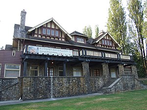
Burnaby Art Gallery
Art museum in British Columbia, Canada
Distance: Approx. 1662 meters
Latitude and longitude: 49.241,-122.9713
The Burnaby Art Gallery (abbreviated as BAG) is an art museum in Burnaby, British Columbia, Canada. The museum is located on the northern periphery of Deer Lake Park, situated off of Deer Lake Avenue. The museum occupies Fairacres Mansion, designated as a historic site by the municipal and provincial governments.
Oakalla Prison
Prison farm in British Columbia, Canada 1912–1991
Distance: Approx. 1748 meters
Latitude and longitude: 49.2321,-122.9855
The Oakalla Prison Farm (also known as the Lower Mainland Regional Correctional Centre or LMRCC) was a model prison farm on 185 acres (75 ha) of land next to Deer Lake, Burnaby, British Columbia, Canada. The Oakalla Prison Farm opened in 1912 and was initially designed to hold 150 men and women. In 1916, the women's section officially opened, and in 1942 the woman's unit, being a whole separate facility opened on the grounds.
Weather in this IP's area
few clouds
17 Celsius
17 Celsius
15 Celsius
18 Celsius
1015 hPa
80 %
1015 hPa
1009 hPa
10000 meters
3.6 m/s
210 degree
20 %
06:53:34
19:18:21