Country:
 Canada
Region:
City:
Latitude and Longitude:
Time Zone:
Postal Code:
IP information under different IP Channel
ip-api
Country
Region
City
ASN
Time Zone
ISP
Blacklist
Proxy
Latitude
Longitude
Postal
Route
IPinfo
Country
Region
City
ASN
Time Zone
ISP
Blacklist
Proxy
Latitude
Longitude
Postal
Route
MaxMind
Country
Region
City
ASN
Time Zone
ISP
Blacklist
Proxy
Latitude
Longitude
Postal
Route
Luminati
Country
CARegion
bc
City
langley
ASN
Time Zone
America/Vancouver
ISP
OXIO-ASN-01
Latitude
Longitude
Postal
db-ip
Country
Region
City
ASN
Time Zone
ISP
Blacklist
Proxy
Latitude
Longitude
Postal
Route
ipdata
Country
Region
City
ASN
Time Zone
ISP
Blacklist
Proxy
Latitude
Longitude
Postal
Route
Popular places and events near this IP address
Catholic Pacific College
Distance: Approx. 3098 meters
Latitude and longitude: 49.14285,-122.602382
Catholic Pacific College (formerly Redeemer Pacific College) is a private Catholic post-secondary institution in Langley, British Columbia, which is located on the west coast of Canada. It is endorsed by the Cardinal Newman Society in The Newman Guide to Choosing a Catholic College. It was founded in 1999 as Redeemer Pacific College, and changed its name to Catholic Pacific College in 2015.

Fort Langley
Community in British Columbia, Canada
Distance: Approx. 348 meters
Latitude and longitude: 49.16855,-122.57976389
Fort Langley is a village community in Township of Langley, British Columbia, Canada. It has a population of approximately 3,400 people. It is the home of Fort Langley National Historic Site, a former fur trade post of the Hudson's Bay Company.
Fort Langley Airport
Airport in Fort Langley, British Columbia
Distance: Approx. 2189 meters
Latitude and longitude: 49.1675,-122.55444444
Fort Langley Airport (TC LID: CBQ2) is a small private airport located in Fort Langley, British Columbia, Canada. It was built in 1959 and had a grass runway; it now has an asphalt runway that stretches to 5510 feet and is located adjacent to the Fort Langley Water Aerodrome.

Fort Langley National Historic Site
Former trading post of the Hudson's Bay Company in British Columbia, Canada
Distance: Approx. 1096 meters
Latitude and longitude: 49.16805556,-122.56944444
Fort Langley National Historic Site, commonly shortened to Fort Langley, is a former fur trading post of the Hudson's Bay Company in the community of Fort Langley of Langley, British Columbia, Canada. The national historic site sits above the banks of the Bedford Channel across McMillan Island. The national historic site contains a visitor centre and a largely reconstructed trading post that contains ten structures surrounded by wooden palisades.

Kwantlen First Nation
Indigenous reserve in British Columbia, Canada
Distance: Approx. 348 meters
Latitude and longitude: 49.16855,-122.57976389
Kwantlen First Nation (Halkomelem: qw̓ɑ:nƛ̓ə̓n̓) is a First Nations band government in British Columbia, Canada, located primarily on McMillan Island near Fort Langley. The Kwantlen people traditionally speak hən̓q̓əmin̓əm̓, the Downriver dialect of Halkomelem, one of the Salishan family languages. The Kwantlen are a Stó:lō people (an ethnicity which includes the nearby Katzie and Kwikwetlem First Nations among many others throughout British Columbia's Lower Mainland region), though as of June 2018, Kwantlen withdrew from the Sto:lo Tribal Council and currently operates as an independent Nation.
McMillan Island
Distance: Approx. 1402 meters
Latitude and longitude: 49.17638889,-122.57
McMillan Island is an island in the Fraser River, British Columbia, Canada, also known as McMillan Slough..
Albion, British Columbia
Distance: Approx. 3030 meters
Latitude and longitude: 49.18333333,-122.55
Albion, British Columbia is a neighbourhood in Maple Ridge, British Columbia and is one of several small towns incorporated within the municipality at its creation. It is the oldest non-indigenous community of the district's settlements, and is only slightly younger than Fort Langley, adjacent across the Fraser River, and Kanaka Creek, which is just to the west and lies along the creek of the same name. Its official definition is the area bounded by the Fraser River, Kanaka Way, and 240th Street, but in its historic sense it means the community centred on and flanking 240th Street and adjoining areas along the Fraser River waterfront and around the Maple Ridge Fairgrounds, while along Kanaka Way and also on the near bank of Kanaka Creek, the creek, is historically the community of Kanaka Creek.

Bedford Channel
Distance: Approx. 181 meters
Latitude and longitude: 49.16666667,-122.58333333
The Bedford Channel is a small side channel of the Fraser River near the north end of the Township of Langley, on the south side of McMillan Island. The pair of islands—Brae Island and McMillan Island that protect the riverfront of Fort Langley, British Columbia are reached by the bridge that crosses the Bedford Channel on the way to the now-closed Albion Ferry terminal and the main reserve community of the Kwantlen First Nation on McMillan Island. The Bedford name has been used in the name of a new housing development in the town of Fort Langley.
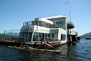
McBarge
Former McDonald's floating restaurant at Expo 86 in Vancouver
Distance: Approx. 2100 meters
Latitude and longitude: 49.184193,-122.56943
The McBarge, officially named the Friendship 500, is a former McDonald's restaurant, built on a 187-foot-long (57 m) barge for Expo '86 in Vancouver, British Columbia. Moored on Expo grounds in Vancouver's False Creek, it was the second floating McDonald's location in the world (the first being in St. Louis, Missouri), intended to showcase future technology and architecture.
Associated Canadian Theological Schools
Distance: Approx. 3454 meters
Latitude and longitude: 49.139018,-122.601028
The Associated Canadian Theological Schools (ACTS Seminaries) is an interdenominational consortium of evangelical Christian seminaries in Canada, embedded as a graduate schools of theology within Trinity Western University. Together, the consortium jointly grants master's and doctoral degrees in biblical studies, theology, ministry, linguistics, chaplaincy and marriage and family therapy. ACTS Seminaries is an accredited member of the Association of Theological Schools.
Salmon River (Langley)
Distance: Approx. 994 meters
Latitude and longitude: 49.17694444,-122.58638889
The Salmon River is a small river in the Township of Langley in the Lower Mainland region of British Columbia, Canada, flowing northwest then northeast to enter Bedford Channel, which separates McMillan Island from Fort Langley, which is just southwest. The river is one of the only fish stock sustaining streams remaining in the Metro Vancouver area.
Statue of James Douglas
Distance: Approx. 824 meters
Latitude and longitude: 49.16802475,-122.57318119
A statue of James Douglas is installed outside the Fort Langley National Historic Site in Fort Langley, British Columbia, Canada.
Weather in this IP's area
broken clouds
17 Celsius
16 Celsius
15 Celsius
18 Celsius
1015 hPa
73 %
1015 hPa
1013 hPa
10000 meters
0.51 m/s
0.76 m/s
191 degree
75 %
06:51:58
19:16:41