Country:
 Canada
Region:
City:
Latitude and Longitude:
Time Zone:
Postal Code:
IP information under different IP Channel
ip-api
Country
Region
City
ASN
Time Zone
ISP
Blacklist
Proxy
Latitude
Longitude
Postal
Route
IPinfo
Country
Region
City
ASN
Time Zone
ISP
Blacklist
Proxy
Latitude
Longitude
Postal
Route
MaxMind
Country
Region
City
ASN
Time Zone
ISP
Blacklist
Proxy
Latitude
Longitude
Postal
Route
Luminati
Country
CARegion
bc
City
northvancouver
ASN
Time Zone
America/Vancouver
ISP
OXIO-ASN-01
Latitude
Longitude
Postal
db-ip
Country
Region
City
ASN
Time Zone
ISP
Blacklist
Proxy
Latitude
Longitude
Postal
Route
ipdata
Country
Region
City
ASN
Time Zone
ISP
Blacklist
Proxy
Latitude
Longitude
Postal
Route
Popular places and events near this IP address
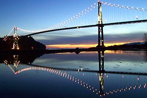
Lions Gate Bridge
Suspension bridge in Vancouver, Canada
Distance: Approx. 1793 meters
Latitude and longitude: 49.31527778,-123.13833333
The Lions Gate Bridge, opened in 1938 and officially known as the First Narrows Bridge, is a suspension bridge that crosses the first narrows of Burrard Inlet and connects the City of Vancouver, British Columbia, to the North Shore municipalities of the District of North Vancouver, the City of North Vancouver, and West Vancouver. The term "Lions Gate" refers to the Lions, a pair of mountain peaks north of Vancouver. Northbound traffic on the bridge heads in their general direction.
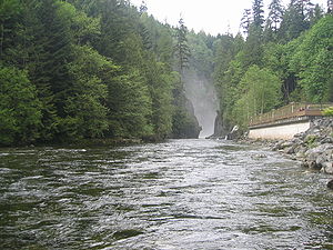
Capilano River
River in British Columbia, Canada
Distance: Approx. 1143 meters
Latitude and longitude: 49.32111111,-123.13944444
The Capilano River flows from north to south through the Coast Mountains on the North Shore of the Burrard Inlet between British Columbia's district municipalities of West Vancouver and North Vancouver and empties into Burrard Inlet, opposite Stanley Park. The river is one of three primary sources of drinking water for residents of Greater Vancouver, and flows through the Capilano watershed. The Cleveland Dam, built in 1954, impounds a reservoir for this purpose.
West Vancouver Secondary School
Public school in West Vancouver, British Columbia, Canada
Distance: Approx. 1386 meters
Latitude and longitude: 49.33648,-123.16086
West Vancouver Secondary School (WVSS) is a five-year secondary school located in the middle of West Vancouver, British Columbia which educates grades 8 through 12. It is one of the three public high schools in West Vancouver. The school has two campuses, a North Campus and a South Campus.
Sentinel Secondary School
Public school in West Vancouver, British Columbia, Canada
Distance: Approx. 1701 meters
Latitude and longitude: 49.34563,-123.15046
Sentinel Secondary School is a secondary school located in West Vancouver, British Columbia, Canada. It is one of three public secondary schools in the West Vancouver district (SD #45) including West Vancouver Secondary School and Rockridge Secondary School. The school is the only school in the West Vancouver district featuring French immersion program.

Park Royal Shopping Centre
Shopping mall in British Columbia, Canada
Distance: Approx. 739 meters
Latitude and longitude: 49.326,-123.137
Park Royal Shopping Centre, also known as simply Park Royal, opened in 1950, is a shopping mall located in West Vancouver and X̱wemelch'stn, British Columbia, Canada. Park Royal was Canada's first covered shopping mall. Park Royal has seen multiple redeveloped projects within the last decade.
X̱wemelch'stn
Distance: Approx. 1764 meters
Latitude and longitude: 49.31666667,-123.13333333
X̱wemelch'stn [χʷəməltʃʼstn], usually anglicized as Homulchesan, is a large community within the Squamish Nation of the Squamish people, who are a part of the Coast Salish ethnic and linguistic group. The name X̱wemelch'stn, translates to "Fast Moving Water of Fish", relating to the Capilano River. The village is one of the oldest and major villages of the Squamish and continues to be so, being the Squamish Nation's most populated reserve.
West Vancouver Memorial Library
Public library in British Columbia
Distance: Approx. 1590 meters
Latitude and longitude: 49.3286,-123.1653
The West Vancouver Memorial Library (WVML) is a public library that serves the district municipality of West Vancouver, British Columbia, Canada.

Ambleside, West Vancouver
Distance: Approx. 992 meters
Latitude and longitude: 49.328298,-123.156729
Ambleside is a neighbourhood in West Vancouver that occupies the southeastern corner of the community, with only Park Royal being farther east. The neighborhood is bordered by the neighbourhoods of Dundarave, Park Royal, and the British Properties. Ambleside covers the area from 19th Street to 13th Street, and from Fulton Avenue down to the waterfront.
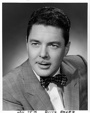
The Attic (restaurant)
Former West Vancouver restaurant
Distance: Approx. 775 meters
Latitude and longitude: 49.32777778,-123.13423056
The Attic was a popular 1,200 seat Smörgåsbord restaurant in West Vancouver, British Columbia that was open from 1968 to 1981. The owners were former Vancouver alderman Frank Baker (1922–1989) and his wife Dorothy.
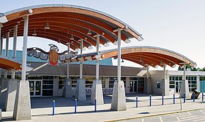
Park Royal Exchange
Distance: Approx. 543 meters
Latitude and longitude: 49.32666667,-123.14027778
Park Royal Exchange is an on-street transit exchange in West Vancouver, British Columbia, Canada. Opened on October 16, 1959, it lies on Marine Drive at the Park Royal Shopping Centre and has connections to the Horseshoe Bay Ferry Terminal, the City and District of North Vancouver (including Capilano University), and Vancouver.

First Narrows (Vancouver)
Distance: Approx. 1612 meters
Latitude and longitude: 49.31666667,-123.14055556
First Narrows is the official name for the entrance to Burrard Inlet, the mouth of Vancouver, British Columbia's inner harbour.
West Vancouver Art Museum
Distance: Approx. 1170 meters
Latitude and longitude: 49.3304,-123.1598
The West Vancouver Art Museum was founded in 1994 and occupies the historic Gertrude Lawson house in Vancouver, British Columbia, Canada. Its permanent collection includes work by B.C. Binning and Gordon A. Smith, and has hosted exhibits by artists including Cornelia Hahn Oberlander and Douglas Coupland. It hosts the West Vancouver Modern Week, and in 2010 was home to the project Monster for the 2010 Winter Olympics.
Weather in this IP's area
few clouds
17 Celsius
17 Celsius
16 Celsius
18 Celsius
1015 hPa
81 %
1015 hPa
1009 hPa
10000 meters
3.6 m/s
210 degree
20 %
06:54:09
19:18:59