Country:
 Canada
Region:
City:
Latitude and Longitude:
Time Zone:
Postal Code:
IP information under different IP Channel
ip-api
Country
Region
City
ASN
Time Zone
ISP
Blacklist
Proxy
Latitude
Longitude
Postal
Route
IPinfo
Country
Region
City
ASN
Time Zone
ISP
Blacklist
Proxy
Latitude
Longitude
Postal
Route
MaxMind
Country
Region
City
ASN
Time Zone
ISP
Blacklist
Proxy
Latitude
Longitude
Postal
Route
Luminati
Country
CARegion
bc
City
langley
ASN
Time Zone
America/Vancouver
ISP
OXIO-ASN-01
Latitude
Longitude
Postal
db-ip
Country
Region
City
ASN
Time Zone
ISP
Blacklist
Proxy
Latitude
Longitude
Postal
Route
ipdata
Country
Region
City
ASN
Time Zone
ISP
Blacklist
Proxy
Latitude
Longitude
Postal
Route
Popular places and events near this IP address
Langley, British Columbia (city)
City in British Columbia, Canada
Distance: Approx. 3469 meters
Latitude and longitude: 49.1041,-122.65758
The City of Langley, commonly referred to as Langley City, or just Langley, is a municipality in the Metro Vancouver Regional District in British Columbia, Canada. It lies directly east of Surrey, adjacent to the Cloverdale area, and is surrounded elsewhere by the Township of Langley, bordered by its neighbourhoods of Willowbrook to the north, Murrayville to the east, and Brookswood and Fern Ridge to the south.
Catholic Pacific College
Distance: Approx. 2456 meters
Latitude and longitude: 49.14285,-122.602382
Catholic Pacific College (formerly Redeemer Pacific College) is a private Catholic post-secondary institution in Langley, British Columbia, which is located on the west coast of Canada. It is endorsed by the Cardinal Newman Society in The Newman Guide to Choosing a Catholic College. It was founded in 1999 as Redeemer Pacific College, and changed its name to Catholic Pacific College in 2015.
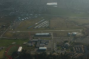
Langley Regional Airport
Airport in Langley, British Columbia
Distance: Approx. 2770 meters
Latitude and longitude: 49.10083333,-122.63083333
Langley Regional Airport (IATA: YLY, ICAO: CYNJ) is located in Langley Township, British Columbia, Canada. It serves mostly general aviation, and also provided scheduled passenger service to the Victoria Airport Water Aerodrome via Harbour Air Seaplanes before service was ended on May 20, 2011. Helicopter operations are a major part of Langley Airport's traffic; the airport has three helipads.
Canadian Museum of Flight
Aviation museum in Langley, British Columbia, Canada
Distance: Approx. 2874 meters
Latitude and longitude: 49.099394,-122.626068
The Canadian Museum of Flight (formally the Canadian Museum of Flight Association since 1998) is an aviation museum at the Langley Regional Airport in Langley, British Columbia, Canada. The museum has over 25 civilian and military jets, piston driven engine aircraft, gliders, and helicopters on display, six of which have been restored to flying condition. Other displays include an aviation art gallery and aviation artifacts.

Langley Secondary School
High school in Langley, British Columbia, Canada
Distance: Approx. 2279 meters
Latitude and longitude: 49.10529,-122.63027
Langley Secondary is a public high school in Langley, British Columbia part of School District 35 Langley. It is the oldest secondary school in the Langley School District, having been opened in 1949. Langley Secondary offers programs for students in Grade 9 to 12 and has strong traditions in academics, fine arts and athletics.

R. E. Mountain Secondary School
High school in Langley, British Columbia, Canada
Distance: Approx. 3569 meters
Latitude and longitude: 49.1439,-122.6621
R.E. Mountain Secondary is a public high school in northern Langley, British Columbia and is a part of School District 35 Langley. It originally opened in 1977 and was relocated to a new facility in 2019. As of 2014, the school no longer offers Grade 8 as Yorkson Creek Middle School took the position.

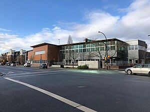
Langley Centre
Public transit exchange in Langley, British Columbia, Canada
Distance: Approx. 3129 meters
Latitude and longitude: 49.10638889,-122.65444444
Langley Centre is an on-street bus exchange located in downtown Langley City, British Columbia, Canada. As part of the TransLink system, it serves the municipalities of Langley City and Langley Township with routes to Surrey, Maple Ridge, and White Rock, that provide connections to SkyTrain and the West Coast Express rail services for travel towards Vancouver.
Willoughby, Langley
Distance: Approx. 3167 meters
Latitude and longitude: 49.149,-122.646
Willoughby, British Columbia is a community located within the Township of Langley. It is also home to the Township of Langley's municipal hall.
Milner, British Columbia
Neighbourhood in Lower Mainland, British Columbia, Canada
Distance: Approx. 1007 meters
Latitude and longitude: 49.13333333,-122.61666667
Milner is a rural village (small town) and locality in the Township of Langley in the Fraser Valley of British Columbia, Canada. It is located along the British Columbia Electric Railway line (now the Southern Railway of B.C.) northeast of the City of Langley and just southwest of Fort Langley. Local businesses include Milner Downs Equestrian Center, Milner Village Garden Centre, Milner Feed and Pet Supply Ltd., and Milner Valley Cheese.

Langley Education Centre
High school in Langley, British Columbia, Canada
Distance: Approx. 2398 meters
Latitude and longitude: 49.104,-122.629
Langley Education Centre (LEC) is a public high school in Langley, British Columbia, part of School District 35 Langley. LEC offers secondary school (Gr. 10–12) options for teens and adults to continue and complete a secondary education or upgrade their courses.
Associated Canadian Theological Schools
Distance: Approx. 2196 meters
Latitude and longitude: 49.139018,-122.601028
The Associated Canadian Theological Schools (ACTS Seminaries) is an interdenominational consortium of evangelical Christian seminaries in Canada, embedded as a graduate schools of theology within Trinity Western University. Together, the consortium jointly grants master's and doctoral degrees in biblical studies, theology, ministry, linguistics, chaplaincy and marriage and family therapy. ACTS Seminaries is an accredited member of the Association of Theological Schools.

Langley Memorial Hospital
Hospital in British Columbia, Canada
Distance: Approx. 3386 meters
Latitude and longitude: 49.09538,-122.61254
Langley Memorial Hospital is a government-funded 188-bed acute care facility, and Level IV trauma centre in Township of Langley, British Columbia that is owned and operated by Fraser Health.
Weather in this IP's area
broken clouds
17 Celsius
17 Celsius
15 Celsius
18 Celsius
1015 hPa
81 %
1015 hPa
1013 hPa
10000 meters
1.03 m/s
240 degree
60 %
06:52:08
19:16:49