Country:
 Canada
Region:
City:
Latitude and Longitude:
Time Zone:
Postal Code:
IP information under different IP Channel
ip-api
Country
Region
City
ASN
Time Zone
ISP
Blacklist
Proxy
Latitude
Longitude
Postal
Route
IPinfo
Country
Region
City
ASN
Time Zone
ISP
Blacklist
Proxy
Latitude
Longitude
Postal
Route
MaxMind
Country
Region
City
ASN
Time Zone
ISP
Blacklist
Proxy
Latitude
Longitude
Postal
Route
Luminati
Country
CARegion
bc
City
vancouver
ASN
Time Zone
America/Vancouver
ISP
OXIO-ASN-01
Latitude
Longitude
Postal
db-ip
Country
Region
City
ASN
Time Zone
ISP
Blacklist
Proxy
Latitude
Longitude
Postal
Route
ipdata
Country
Region
City
ASN
Time Zone
ISP
Blacklist
Proxy
Latitude
Longitude
Postal
Route
Popular places and events near this IP address

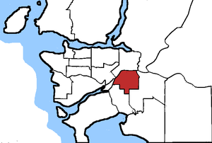
Surrey, British Columbia
City in British Columbia, Canada
Distance: Approx. 387 meters
Latitude and longitude: 49.19,-122.84888889
Surrey is a city in British Columbia, Canada. It is located south of the Fraser River on the Canada–United States border. It is a member municipality of the Metro Vancouver regional district and metropolitan area.

King George station
Metro Vancouver SkyTrain station
Distance: Approx. 681 meters
Latitude and longitude: 49.1827,-122.8446
King George is an elevated station on the Expo Line of Metro Vancouver's SkyTrain rapid transit system. The station is located in the south end of the Surrey City Centre district of Surrey, British Columbia, Canada, and is one of the outbound termini of the Expo Line, the other being Production Way–University station. The station is located on King George Boulevard at Holland Commons, just north of Fraser Highway.
Surrey North (federal electoral district)
Federal electoral district in British Columbia, Canada
Distance: Approx. 333 meters
Latitude and longitude: 49.191,-122.847
Surrey North was a federal electoral district in British Columbia, Canada, that was represented in the House of Commons of Canada from 1988 to 2015. It covered the northern part of Surrey. It was home to 106,904 residents in 2001, more than 46 percent of whom are immigrants—21 percent of residents are East Indian, the second-highest concentration in Canada.

Surrey Central station
Metro Vancouver SkyTrain station
Distance: Approx. 298 meters
Latitude and longitude: 49.189473,-122.847871
Surrey Central is an elevated station on the Expo Line of Metro Vancouver's SkyTrain rapid transit system. The station is located in the Whalley / City Centre district of Surrey, British Columbia, Canada, just east of the North Surrey Recreation Centre. The station is within walking distance of the Central City shopping centre, Surrey City Hall, and SFU Surrey, the Surrey campus of Simon Fraser University.
Whalley, Surrey
Town centre of Surrey in British Columbia, Canada
Distance: Approx. 349 meters
Latitude and longitude: 49.19166667,-122.84583333
Whalley is the most densely populated and urban of the six town centres in Surrey, British Columbia, Canada. It encompasses City Centre, the city's central business district, and is home to the Surrey City Hall, the main branch of Surrey Libraries, Central City, SFU Surrey and the site of Kwantlen Polytechnic University's (KPU) Civic Plaza campus. It is the only town centre in Surrey served by Metro Vancouver's SkyTrain rapid transit system.
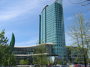
Central City (Surrey, British Columbia)
Mixed-use development in British Columbia, Canada
Distance: Approx. 448 meters
Latitude and longitude: 49.1875,-122.84972222
Central City (formerly known as Surrey Place Mall) is a mixed-use development that houses a shopping mall, a university campus and an office tower complex in Surrey, British Columbia, Canada. It is owned by Blackwood Partners Management Corporation. The Central City tower, main entrance and galleria were designed by Bing Thom Architects.
King George Tower
Mixed-use in Surrey, British Columbia
Distance: Approx. 591 meters
Latitude and longitude: 49.1835,-122.8435
King George Tower was a proposed skyscraper in Surrey, British Columbia near King George Station. At a height of 274.3 m (900 ft) with 81 stories, the mixed-use building would have been significantly taller than any highrise building in the Vancouver area. The skyscraper also would have had the most floors of any building in Canada, exceeding the 78 floors of Aura in Toronto, Ontario.
Surrey City Centre Public Library
Distance: Approx. 443 meters
Latitude and longitude: 49.19057,-122.84936
The Surrey City Centre Library is the main branch of Surrey Libraries (Surrey, British Columbia's public library system). It was opened in September 2011 and replaced the Whalley Public Library. Part of a re-vitalization project for the City Centre area, the building was designed by Bing Thom.

Surrey Centre
Federal electoral district in British Columbia, Canada
Distance: Approx. 262 meters
Latitude and longitude: 49.19,-122.847
Surrey Centre (French: Surrey-Centre) is a federal electoral district in British Columbia. It encompasses a portion of British Columbia previously included in the electoral district of Surrey North. Surrey Centre was created by the 2012 federal electoral boundaries redistribution and was legally defined in the 2013 representation order.

3 Civic Plaza
Mixed-use complex in Surrey, British Columbia, Canada
Distance: Approx. 399 meters
Latitude and longitude: 49.18678333,-122.84844167
3 Civic Plaza, also referred to as 3 Civic Tower is a mixed-use complex in the Whalley / City Centre neighbourhood of Surrey, British Columbia, Canada, near Surrey City Hall. The building was completed in late 2018. At 157.3 metres (516 ft) tall, it is the tallest building in Surrey and overtook the previous record-holder, the Central City complex, which was the tallest building in Surrey from 2003 to 2018.

Holland Park, Surrey
Distance: Approx. 648 meters
Latitude and longitude: 49.183781,-122.848419
Holland Park is a park in the city of Surrey, British Columbia, Canada, located within Whalley / City Centre beside Central City. It is 10 hectares (25 acres) in size and although it is not the largest park in the city, it has been called the "Central Park" of Surrey city centre. Originally a piece of land that was unused and not landscaped, the city of Surrey designated the area as an urban park and was transformed in the mid-2000s.

King George Hub
Mixed-use development
Distance: Approx. 856 meters
Latitude and longitude: 49.18111111,-122.84388889
King George Hub is a mixed-use development with retail, office and residential high-rises in Surrey, British Columbia, Canada, located at the northeast corner of King George Boulevard and Fraser Highway in the Surrey City Centre district. Developed by the PCI Group and designed by MCM Partnership, the project is located adjacent to the transit hub at King George station.
Weather in this IP's area
broken clouds
17 Celsius
16 Celsius
15 Celsius
17 Celsius
1015 hPa
80 %
1015 hPa
1005 hPa
10000 meters
1.03 m/s
240 degree
56 %
06:53:00
19:17:44