Country:
 Canada
Region:
City:
Latitude and Longitude:
Time Zone:
Postal Code:
IP information under different IP Channel
ip-api
Country
Region
City
ASN
Time Zone
ISP
Blacklist
Proxy
Latitude
Longitude
Postal
Route
IPinfo
Country
Region
City
ASN
Time Zone
ISP
Blacklist
Proxy
Latitude
Longitude
Postal
Route
MaxMind
Country
Region
City
ASN
Time Zone
ISP
Blacklist
Proxy
Latitude
Longitude
Postal
Route
Luminati
Country
CARegion
bc
City
coquitlam
ASN
Time Zone
America/Vancouver
ISP
OXIO-ASN-01
Latitude
Longitude
Postal
db-ip
Country
Region
City
ASN
Time Zone
ISP
Blacklist
Proxy
Latitude
Longitude
Postal
Route
ipdata
Country
Region
City
ASN
Time Zone
ISP
Blacklist
Proxy
Latitude
Longitude
Postal
Route
Popular places and events near this IP address

Anmore
Village in British Columbia, Canada
Distance: Approx. 1253 meters
Latitude and longitude: 49.31444444,-122.85638889
Anmore is a village in Metro Vancouver, British Columbia, Canada. It is north of the city of Port Moody and along the shores of the Indian Arm. Anmore is one of three politically independent village municipalities (municipalities with populations under 2,500) in the Greater Vancouver area, the others being its neighbour Belcarra, and Lions Bay.
Heritage Woods Secondary School
Coeducational secondary school in Port Moody, British Columbia, Canada
Distance: Approx. 3323 meters
Latitude and longitude: 49.29861111,-122.84111111
Heritage Woods Secondary School is a coeducational high school located in Port Moody, British Columbia. In 2007, Heritage Woods celebrated their first graduating class. As well, it was rated as one of the top 50 schools in British Columbia for 2007, 2008 and 2010 and top 30 in 2012 by the Fraser Institute.
Belcarra Regional Park
Regional park in British Columbia
Distance: Approx. 2349 meters
Latitude and longitude: 49.3184,-122.8936
təmtəmíxʷtən/Belcarra Regional Park is a 1,100-hectare (2,700-acre) regional park located in Belcarra, Greater Vancouver, British Columbia. It is northeast of the meeting of Burrard Inlet with Indian Arm, beginning near Belcarra Bay and extending to Sasamat Lake. The park is northwest of the Village of Anmore and to the southwest of Buntzen Lake.
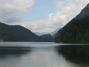
Buntzen Lake
Body of water in British Columbia, Canada
Distance: Approx. 2690 meters
Latitude and longitude: 49.349,-122.86
Buntzen Lake is a 4.8 kilometres (3 mi) long lake in Anmore, British Columbia, Canada, in the Greater Vancouver area. It is named after the first general manager of the B.C. Electric Co., Johannes Buntzen.: 32 There is a smaller lake just to the north named McCombe Lake.
Eagle Mountain (British Columbia)
Mountain in British Columbia, Canada
Distance: Approx. 3485 meters
Latitude and longitude: 49.34777778,-122.83
Eagle Mountain, also known as Eagle Ridge, is the mountainous ridge with many indistinct summits between Buntzen Lake and Coquitlam Lake near Coquitlam, British Columbia. Its proximity to Coquitlam, and the houses being built on its southern slopes (known as Westwood Plateau), make it a very popular weekend destination for hiking, mountain biking, horseback riding, and ATV riding. There is a network of logging roads leading up the south side of the summit to a plateau area with lakes, hiking trails and mountain biking trails.
Sasamat Lake
Distance: Approx. 1950 meters
Latitude and longitude: 49.321,-122.889
Sasamat Lake is located within Belcarra Regional Park in Port Moody, British Columbia. It is one of the warmest lakes in Greater Vancouver. At the south end of the lake there is a floating bridge, used for fishing or swimming.
Sasamat Outdoor Centre
Distance: Approx. 2328 meters
Latitude and longitude: 49.3234,-122.8948
Sasamat Outdoor Centre is an outdoor facility specializing in 'summer camp' type activities. From the week of July 1 to the end of August the camp offers week-long Day Camps and Resident Camps for ages 6 through 16, and Family Camp opportunities on several weekends. The camp operates on Greater Vancouver Regional District land but has renewed ownership with a twenty-year lease, taking effect in January 2008.
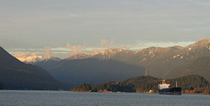
Ioco, Port Moody
Distance: Approx. 2534 meters
Latitude and longitude: 49.3036,-122.8751
Ioco is an area of Port Moody, British Columbia, located on the northern shore of the Burrard Inlet. Ioco, an abbreviation of Imperial Oil Corporation, was originally a townsite for an Imperial Oil refinery. The refinery began operation in January 1915.
Mossom Creek Hatchery
Salmon hatchery in Port Moody, British Columbia
Distance: Approx. 2154 meters
Latitude and longitude: 49.3056533,-122.8596954
Mossom Creek Hatchery is a salmon hatchery in Port Moody, British Columbia. It is a salmon enhancement project supported by Fisheries and Oceans Canada. It was started in 1976 by high school volunteers from local Centennial School in Coquitlam and teachers Ruth Foster and Rod MacVicar.

Port Moody-Coquitlam (provincial electoral district)
Provincial electoral district in British Columbia, Canada
Distance: Approx. 2901 meters
Latitude and longitude: 49.31,-122.83
Port Moody-Coquitlam is a provincial electoral district in British Columbia, Canada, established by the Electoral Districts Act, 2008. It was first contested in the 2009 general election, in which BC Liberal Iain Black was elected as its MLA. Black resigned effective October 3, 2011, so he could accept a job as the president and CEO of the Vancouver Board of Trade. Under the 2021 British Columbia electoral redistribution, the riding will be renamed Port Moody-Burquitlam.
Bedwell Bay
Bay in British Columbia, Canada
Distance: Approx. 3449 meters
Latitude and longitude: 49.32333333,-122.91027778
Bedwell Bay is a bay in British Columbia. It is a part of Indian Arm, and is located in the village municipality of Belcarra.
White Pine Beach
Beach in British Columbia, Canada
Distance: Approx. 2682 meters
Latitude and longitude: 49.320113,-122.899027
White Pine Beach is a beach on Sasamat Lake in Belcarra Regional Park in Port Moody, British Columbia. TransLink provides seasonal bus service. It's a popular beach in the area and many people come here from all over the lower mainland to swim, walk, or just enjoy the sun.
Weather in this IP's area
broken clouds
16 Celsius
15 Celsius
14 Celsius
17 Celsius
1015 hPa
79 %
1015 hPa
987 hPa
10000 meters
0.89 m/s
1.34 m/s
324 degree
79 %
06:53:02
19:17:51