Country:
Region:
City:
Latitude and Longitude:
Time Zone:
Postal Code:
IP information under different IP Channel
ip-api
Country
Region
City
ASN
Time Zone
ISP
Blacklist
Proxy
Latitude
Longitude
Postal
Route
Luminati
Country
Region
bc
City
vancouver
ASN
Time Zone
America/Vancouver
ISP
OXIO-ASN-01
Latitude
Longitude
Postal
IPinfo
Country
Region
City
ASN
Time Zone
ISP
Blacklist
Proxy
Latitude
Longitude
Postal
Route
db-ip
Country
Region
City
ASN
Time Zone
ISP
Blacklist
Proxy
Latitude
Longitude
Postal
Route
ipdata
Country
Region
City
ASN
Time Zone
ISP
Blacklist
Proxy
Latitude
Longitude
Postal
Route
Popular places and events near this IP address

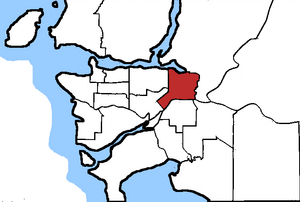
New Westminster—Coquitlam
Federal electoral district in British Columbia, Canada
Distance: Approx. 1454 meters
Latitude and longitude: 49.252,-122.85
New Westminster—Coquitlam was a federal electoral district in British Columbia, Canada, that was represented in the House of Commons of Canada from 1979 to 1988, and from 2004 to 2015.
Centennial Secondary School (Coquitlam)
High school in Coquitlam, British Columbia, Canada
Distance: Approx. 1601 meters
Latitude and longitude: 49.25305556,-122.84777778
Centennial Secondary School is a high school located in Coquitlam, British Columbia. Established in 1967, the centennial year of Canadian Confederation, it is part of School District 43 Coquitlam. Centennial has approximately 1300 students and is structured on a semester system.
Brunette River
River in British Columbia, Canada
Distance: Approx. 1883 meters
Latitude and longitude: 49.23035,-122.875271
The Brunette River runs through East Burnaby, New Westminster and Coquitlam, flowing out of Burnaby Lake and to the Fraser River. It is the final outflow of the Central Valley Watershed, which consists of most streams between the Ulksen and Burnaby Heights. According to a map and materials by Heritage Advisory Committee and Environment and Waste Management Committee of the City of Burnaby (1993), the number of native campsites discovered on the shores of the Fraser River, Burrard Inlet and Deer Lake and some petroglyphs suggest that the area was used extensively by local aboriginal peoples such as the Squamish, Musqueam and Kwantlen for hunting and fishing before the arrival of European settlers.

Poirier Sport & Leisure Complex
Distance: Approx. 1867 meters
Latitude and longitude: 49.255011,-122.844958
Poirier Sport & Leisure Complex is a 190,000-square-foot multi-purpose all-season recreation complex in Coquitlam, British Columbia.
Hard Rock Casino Vancouver
Casino in British Columbia, Canada
Distance: Approx. 1751 meters
Latitude and longitude: 49.227306,-122.837158
Great Canadian Casino Vancouver (formerly Hard Rock Casino & Boulevard Casino) in Coquitlam, British Columbia is the largest casino in the province of British Columbia by gaming space. The casino is open 24 hours a day and is owned by Great Canadian Entertainment. According to their 2006-07 annual report, Boulevard Casino was the third most profitable gaming venue in B.C., bringing in more than $158 million for the year (up to $28.9 million over the previous year).
Maillardville
Neighbourhood of Coquitlam in Lower Mainland, British Columbia, Canada
Distance: Approx. 1028 meters
Latitude and longitude: 49.2374,-122.867
Maillardville is a community on the south slope of the city of Coquitlam, British Columbia, Canada.
Place des Arts (Coquitlam)
Not-for-profit arts organization
Distance: Approx. 590 meters
Latitude and longitude: 49.2387,-122.8612
Place des Arts is a non-profit teaching arts centre and music school located in the Maillardville area of Coquitlam, British Columbia. Founded in 1972, the centre offers programs in visual arts, music, drama, dance and creative writing. Approximately 80 Place des Arts instructors teach courses to more than 1500 students, while a staff of 20 and over 200 volunteers manage the facility, programs, and exhibitions.

KMS Tools
Canadian retail company
Distance: Approx. 1372 meters
Latitude and longitude: 49.2347542,-122.8707594
KMS Tools & Equipment is an industrial tool distributor. KMS Tools is a Canadian retailer of power tools, automotive, woodworking, welding, metalworking tools with construction equipment and car parts. It was founded in Coquitlam, BC in 1983 by Stan Pridham.
1988 du Maurier Classic
Distance: Approx. 2222 meters
Latitude and longitude: 49.251136,-122.877497
The 1988 du Maurier Classic was contested from June 30 to July 3 at Vancouver Golf Club in Coquitlam, British Columbia. It was the 16th edition of the du Maurier Classic, and the 10th edition as a major championship on the LPGA Tour. This event was won by Sally Little.

Fraser Mills
Human settlement in Coquitlam, British Columbia, Canada
Distance: Approx. 680 meters
Latitude and longitude: 49.23333333,-122.85
Fraser Mills was a municipality in British Columbia on the north bank of the Fraser River that was incorporated in 1913, but has since amalgamated with the City of Coquitlam. Fraser Mills is also the name of a new masterplanned community on the same site. It will include 15 separate multi-unit buildings, a bus station connecting to Braid Station, sports recreation and commercial amenities and a 16 acre park.

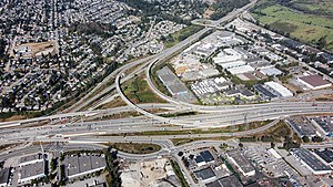
Cape Horn Interchange
Highway interchange in British Columbia, Canada
Distance: Approx. 1858 meters
Latitude and longitude: 49.22922222,-122.8325
The Cape Horn Interchange is a major interchange that connects British Columbia Highway 1 (Trans-Canada Highway) to Lougheed Highway (Highway 7), a heavily signalized thoroughfare in Coquitlam, Port Coquitlam, and Burnaby, and the Mary Hill Bypass (Highway 7B), bypassing the Coquitlam and Port Coquitlam sections of Lougheed Highway and forming the quickest route to Pitt Meadows and Maple Ridge. It also includes several exits to United Boulevard, a light-industrial and commercial road in southern Coquitlam. The Canadian Pacific Railway mainline roughly follows the alignment of Lougheed Highway in this area, and skirts the south and east sides of the interchange.
Inquiry Hub Secondary School
School in Coquitlam, BC
Distance: Approx. 71 meters
Latitude and longitude: 49.23972222,-122.85333333
Inquiry Hub Secondary School is a high school located in Coquitlam, BC, Canada. Established in 2012, it is part of School District 43 Coquitlam. It is a self-guided school that focuses on independent learning versus traditional classroom learning.
Weather in this IP's area
overcast clouds
10 Celsius
9 Celsius
8 Celsius
12 Celsius
1019 hPa
80 %
1019 hPa
1018 hPa
10000 meters
0.51 m/s
100 degree
100 %
07:11:34
16:38:56
