Country:
 Canada
Region:
City:
Latitude and Longitude:
Time Zone:
Postal Code:
IP information under different IP Channel
ip-api
Country
Region
City
ASN
Time Zone
ISP
Blacklist
Proxy
Latitude
Longitude
Postal
Route
IPinfo
Country
Region
City
ASN
Time Zone
ISP
Blacklist
Proxy
Latitude
Longitude
Postal
Route
MaxMind
Country
Region
City
ASN
Time Zone
ISP
Blacklist
Proxy
Latitude
Longitude
Postal
Route
Luminati
Country
CARegion
bc
City
vancouver
ASN
Time Zone
America/Vancouver
ISP
OXIO-ASN-01
Latitude
Longitude
Postal
db-ip
Country
Region
City
ASN
Time Zone
ISP
Blacklist
Proxy
Latitude
Longitude
Postal
Route
ipdata
Country
Region
City
ASN
Time Zone
ISP
Blacklist
Proxy
Latitude
Longitude
Postal
Route
Popular places and events near this IP address
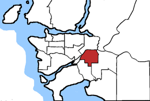
Surrey North (federal electoral district)
Federal electoral district in British Columbia, Canada
Distance: Approx. 2713 meters
Latitude and longitude: 49.191,-122.847
Surrey North was a federal electoral district in British Columbia, Canada, that was represented in the House of Commons of Canada from 1988 to 2015. It covered the northern part of Surrey. It was home to 106,904 residents in 2001, more than 46 percent of whom are immigrants—21 percent of residents are East Indian, the second-highest concentration in Canada.

Whalley, Surrey
Town centre of Surrey in British Columbia, Canada
Distance: Approx. 2615 meters
Latitude and longitude: 49.19166667,-122.84583333
Whalley is the most densely populated and urban of the six town centres in Surrey, British Columbia, Canada. It encompasses City Centre, the city's central business district, and is home to the Surrey City Hall, the main branch of Surrey Libraries, Central City, SFU Surrey and the site of Kwantlen Polytechnic University's (KPU) Civic Plaza campus. It is the only town centre in Surrey served by Metro Vancouver's SkyTrain rapid transit system.
Guildford, British Columbia
Town centre in Surrey, British Columbia, Canada
Distance: Approx. 1042 meters
Latitude and longitude: 49.19,-122.8
Guildford is a town centre and neighbourhood of Surrey, British Columbia, Canada. It is known for its retail corridors along 104 Avenue and 152 Street. At the intersection of these two streets sits the 200-store Guildford Town Centre (also known as the Guildford Shopping Centre).

Fraser Heights Secondary School
High school in Surrey, British Columbia, Canada
Distance: Approx. 2436 meters
Latitude and longitude: 49.1979,-122.7772
Fraser Heights Secondary is a public high school in the Fraser Heights neighbourhood situated in Surrey, British Columbia and is part of School District 36 Surrey. The school is known for its excellence in provincial badminton and volleyball; academics, particularly in the sciences; and extracurricular opportunities. Fraser Heights has an average class size of 28 students.

Johnston Heights Secondary School
Secondary school in Surrey, British Columbia, Canada
Distance: Approx. 1637 meters
Latitude and longitude: 49.18333333,-122.8
Johnston Heights Secondary is a public high school in Surrey, British Columbia, and is part of School District 36 Surrey. The newest building opened in the Fall of 1992. Johnston Heights' exterior highly resembles that of its neighbouring high school, North Surrey Secondary School.

Guildford Exchange
Distance: Approx. 745 meters
Latitude and longitude: 49.191394,-122.803643
Guildford Exchange is a major public transit exchange serving Guildford Town Centre in Surrey, British Columbia, Canada. Opened on May 30, 1975, it is a connection point for routes serving the Whalley, Fleetwood, Guildford and Cloverdale areas of Surrey, as well as Langley Centre. A number of routes using the exchange serve the SkyTrain system via Surrey Central Station.
Port Mann
Town in British Columbia, Canada
Distance: Approx. 1850 meters
Latitude and longitude: 49.21,-122.825
Port Mann townsite was created in 1911 in the municipality of Surrey, British Columbia. The new town was to adjoin the new railway yard and roundhouse forming the terminus of the new trans-national rail-line operated by Canadian Northern Railway. It was named for Donald Mann, a partner in the building of the Canadian Northern Railway.: 211 Newspaper quoted that the town was intended to be a model town.

Surrey Centre
Federal electoral district in British Columbia, Canada
Distance: Approx. 2739 meters
Latitude and longitude: 49.19,-122.847
Surrey Centre (French: Surrey-Centre) is a federal electoral district in British Columbia. It encompasses a portion of British Columbia previously included in the electoral district of Surrey North. Surrey Centre was created by the 2012 federal electoral boundaries redistribution and was legally defined in the 2013 representation order.

Hawthorne Park
Public park in British Columbia, Canada
Distance: Approx. 1202 meters
Latitude and longitude: 49.195,-122.827
Hawthorne Rotary Park is a public park in Surrey, British Columbia. The park's main entrance is located along 144th Street and 104 Avenue. There are many other entrances that can be accessed by foot or vehicle.

Surrey-Guildford
Provincial electoral district in British Columbia, Canada
Distance: Approx. 1413 meters
Latitude and longitude: 49.197,-122.83
Surrey-Guildford is a provincial electoral district for the Legislative Assembly of British Columbia, Canada, that was created in the 2015 redistribution from parts of Surrey-Tynehead and Surrey-Whalley. It was first contested in the 2017 election. Surrey-Guildford consists of a large part of what used to be Surrey-Tynehead, a provincial riding that was held by the BC Liberals since Dave Hayer was first elected in 2001, and then re-elected in 2005 and 2009.
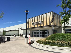
Guildford Town Centre
Shopping mall
Distance: Approx. 864 meters
Latitude and longitude: 49.189994,-122.803671
Guildford Town Centre is a shopping mall located in Surrey, British Columbia, Canada. It opened on November 8, 1966, and is owned by Ivanhoé Cambridge, a Quebec-based real estate company. It is the largest mall in the Lower Mainland south of the Fraser River as well as the third-largest in British Columbia, after Metropolis at Metrotown in Burnaby and Park Royal Shopping Centre in West Vancouver.
Fraser Heights
Neighbourhood of Surrey in Lower Mainland, British Columbia, Canada
Distance: Approx. 2337 meters
Latitude and longitude: 49.1988,-122.7787
Fraser Heights is a neighbourhood of Guildford, a town centre in the city of Surrey, British Columbia. Bounded by Highway 1 to the south, Golden Ears Connector and Golden Ears Way to the east and the Fraser River to the north, with most homes having a view of the Fraser River and Coquitlam Mountain.
Weather in this IP's area
broken clouds
16 Celsius
16 Celsius
15 Celsius
17 Celsius
1015 hPa
79 %
1015 hPa
1003 hPa
10000 meters
0.34 m/s
0.5 m/s
211 degree
61 %
06:52:52
19:17:36