Country:
 Canada
Region:
City:
Latitude and Longitude:
Time Zone:
Postal Code:
IP information under different IP Channel
ip-api
Country
Region
City
ASN
Time Zone
ISP
Blacklist
Proxy
Latitude
Longitude
Postal
Route
IPinfo
Country
Region
City
ASN
Time Zone
ISP
Blacklist
Proxy
Latitude
Longitude
Postal
Route
MaxMind
Country
Region
City
ASN
Time Zone
ISP
Blacklist
Proxy
Latitude
Longitude
Postal
Route
Luminati
Country
CARegion
bc
City
vancouver
ASN
Time Zone
America/Vancouver
ISP
OXIO-ASN-01
Latitude
Longitude
Postal
db-ip
Country
Region
City
ASN
Time Zone
ISP
Blacklist
Proxy
Latitude
Longitude
Postal
Route
ipdata
Country
Region
City
ASN
Time Zone
ISP
Blacklist
Proxy
Latitude
Longitude
Postal
Route
Popular places and events near this IP address
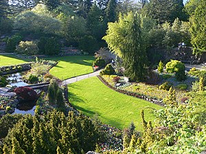
Queen Elizabeth Park, British Columbia
City park in Vancouver, British Columbia, Canada
Distance: Approx. 674 meters
Latitude and longitude: 49.24222222,-123.115
Queen Elizabeth Park is a 130-acre municipal park located in Vancouver, British Columbia, Canada. It is located on top of Little Mountain approximately 125 metres (410 ft) above sea level and is the location of former basalt quarries dug in the beginning of the twentieth century to provide materials for roads in the city.

Bloedel Floral Conservatory
Conservatory and aviary
Distance: Approx. 621 meters
Latitude and longitude: 49.2421,-123.1138
The Bloedel Floral Conservatory is a conservatory and aviary located at the top of Queen Elizabeth Park in Vancouver, British Columbia.

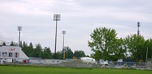
Nat Bailey Stadium
Baseball stadium in western Canada
Distance: Approx. 367 meters
Latitude and longitude: 49.2431,-123.1063
Rogers Field at Nat Bailey Stadium, also known as The Nat, is a baseball stadium in western Canada, located in Vancouver, British Columbia.
Hillcrest Park
Distance: Approx. 148 meters
Latitude and longitude: 49.244872,-123.108147
Hillcrest Park is located in the Riley Park neighbourhood of Vancouver, British Columbia. It is located immediately north of Queen Elizabeth Park and west of Riley Park. Next to Hillcrest Park is the site containing Nat Bailey Stadium, home of the Vancouver Canadians baseball team; the Millennium Sports Centre, home to both the Phoenix Gymnastics Club and the Pacific Indoor Bowls Club; and the Vancouver Racquets Club.

King Edward station
Metro Vancouver SkyTrain station
Distance: Approx. 658 meters
Latitude and longitude: 49.24916667,-123.11583333
King Edward is an underground station on the Canada Line of Metro Vancouver's SkyTrain rapid transit system. The station is located at the intersection of Cambie Street and King Edward Avenue in Vancouver, British Columbia, Canada, and serves the neighbourhoods of Riley Park–Little Mountain and South Cambie. The station is within walking distance of BC Children's Hospital, Nat Bailey Stadium, and Queen Elizabeth Park.
Little Mountain (British Columbia)
Mountain in Canada
Distance: Approx. 636 meters
Latitude and longitude: 49.24166667,-123.11333333
Little Mountain, elevation 125 m (410 ft), is a mountain in the central part of the city of Vancouver, British Columbia, Canada. The mountain is home to Queen Elizabeth Park, which sits at the top of the mountain, and Nat Bailey Stadium, which is located near the base. The mountain lends its name to the Riley Park–Little Mountain neighbourhood, and to the defunct electoral district, Vancouver-Little Mountain.

Roman Catholic Archdiocese of Vancouver
Catholic ecclesiastical territory
Distance: Approx. 719 meters
Latitude and longitude: 49.25,-123.1
The Roman Catholic Archdiocese of Vancouver (Latin: Archidioecesis Vancouveriensis) is a Roman Catholic Latin archdiocese that includes part of the Canadian province of British Columbia.

General Wolfe Elementary School (Vancouver)
Elementary school in Vancouver, British Columbia, Canada
Distance: Approx. 211 meters
Latitude and longitude: 49.24722222,-123.10555556
General Wolfe Elementary is a public elementary school in Vancouver, British Columbia part of School District 39 Vancouver.
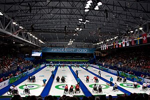
Wheelchair curling at the 2010 Winter Paralympics
Distance: Approx. 157 meters
Latitude and longitude: 49.24486111,-123.10866667
The wheelchair curling competition of the 2010 Winter Paralympics was held at the Vancouver Olympic/Paralympic Centre in Vancouver, British Columbia, Canada, from 13 March to 20 March 2010. Ten teams competed in a single event, a mixed tournament in which men and women competed together.
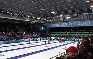
Hillcrest Centre
Athletic center in Vancouver, Canada
Distance: Approx. 195 meters
Latitude and longitude: 49.24444444,-123.10805556
The Hillcrest Centre is a community centre with ice hockey, curling rinks, and an aquatics facility, located at Hillcrest Park in Vancouver, British Columbia, Canada. Construction started in March 2007; it hosted the 2009 World Junior Curling Championships prior to the Olympics. During the 2010 Olympics, it was named the Vancouver Olympic/Paralympic Centre and had a capacity of 6,000 people to host curling at the 2010 Winter Olympics; for the 2010 Paralympics, it hosted the Wheelchair Curling event.
Granville, British Columbia
Town in British Columbia, Canada
Distance: Approx. 719 meters
Latitude and longitude: 49.25,-123.1
Granville was the name from 1870 to 1886 for what would become the townsite of Vancouver, British Columbia. The townsite included the original settlement of Gastown.
Queen Elizabeth Park Disc Golf Course
Disc golf course in British Columbia, Canada
Distance: Approx. 740 meters
Latitude and longitude: 49.23967,-123.10608
Queen Elizabeth Park Disc Golf Course, also known as Little Mountain Disc Golf Course, is an 18-hole disc golf course located in Vancouver, British Columbia, Canada. It was designed by the British Columbia Flying Disc Association in 1984. The course hosted the 1987 Western Canadian Frisbee Championships.
Weather in this IP's area
few clouds
16 Celsius
16 Celsius
15 Celsius
17 Celsius
1015 hPa
82 %
1015 hPa
1006 hPa
10000 meters
3.6 m/s
210 degree
20 %
06:54:02
19:18:48