Country:
 Canada
Region:
City:
Latitude and Longitude:
Time Zone:
Postal Code:
IP information under different IP Channel
ip-api
Country
Region
City
ASN
Time Zone
ISP
Blacklist
Proxy
Latitude
Longitude
Postal
Route
IPinfo
Country
Region
City
ASN
Time Zone
ISP
Blacklist
Proxy
Latitude
Longitude
Postal
Route
MaxMind
Country
Region
City
ASN
Time Zone
ISP
Blacklist
Proxy
Latitude
Longitude
Postal
Route
Luminati
Country
CARegion
bc
City
burnaby
ASN
Time Zone
America/Vancouver
ISP
OXIO-ASN-01
Latitude
Longitude
Postal
db-ip
Country
Region
City
ASN
Time Zone
ISP
Blacklist
Proxy
Latitude
Longitude
Postal
Route
ipdata
Country
Region
City
ASN
Time Zone
ISP
Blacklist
Proxy
Latitude
Longitude
Postal
Route
Popular places and events near this IP address

Brentwood Town Centre station
Metro Vancouver SkyTrain station
Distance: Approx. 1094 meters
Latitude and longitude: 49.26633,-123.00163
Brentwood Town Centre (sometimes abbreviated as Brentwood) is an elevated station on the Millennium Line of Metro Vancouver's SkyTrain rapid transit system. The station is located above Lougheed Highway east of Willingdon Avenue in Burnaby, British Columbia, Canada. The station is adjacent to the Amazing Brentwood, a mid-size shopping centre.

Gilmore station (SkyTrain)
Metro Vancouver SkyTrain station
Distance: Approx. 929 meters
Latitude and longitude: 49.26489,-123.01351
Gilmore is an elevated station on the Millennium Line of Metro Vancouver's SkyTrain rapid transit system. The station is located on Gilmore Avenue in Burnaby, British Columbia, Canada. The station is adjacent to several high-rise condominium complexes which are a component of the Brentwood Town Centre Development Plan, which drives the transformation of the area from a light industrial and lower-occupancy commercial zone into an urbanized centre.
Alpha Secondary School
High school in Burnaby, British Columbia, Canada
Distance: Approx. 1015 meters
Latitude and longitude: 49.2762,-122.9992
Alpha Secondary is a public high school in Burnaby, British Columbia part of School District 41 Burnaby.

The Bridge Studios
Canadian film studio
Distance: Approx. 1238 meters
Latitude and longitude: 49.263611,-123.021029
The Bridge Studios is a Canadian film studio in Burnaby, British Columbia. It operates the largest effects stage in North America. Its eight studios, ranging in size from 4,600 square feet (430 m2) to 40,000 square feet (3,700 m2), are located on a 15-acre (6.1 ha) lot at 2400 Boundary Road.

Kootenay Loop
Public transit exchange in Vancouver, Canada
Distance: Approx. 1356 meters
Latitude and longitude: 49.281362,-123.026252
Kootenay Loop is a transit exchange in Vancouver, British Columbia, Canada. It is the easternmost major transit exchange in the city of Vancouver, with routes serving Vancouver, Burnaby, North Vancouver and the Tri-Cities.

Brentwood Park
Neighourhood in Burnaby, British Columbia
Distance: Approx. 1271 meters
Latitude and longitude: 49.272,-122.995
Brentwood Park, or simply Brentwood, is a neighbourhood in North Burnaby, British Columbia, between Willingdon Avenue to the west and Springer Avenue to the east. Hastings Street separates it from the Capitol Hill area to the north, while Lougheed Highway marks the dividing line between this residential area and an area of commercial and industrial land to the south.

Burnaby Heights
Distance: Approx. 1206 meters
Latitude and longitude: 49.284,-123.0137
Burnaby Heights, often referred to as The Heights, is a residential neighbourhood in North Burnaby between Boundary Road to the west, Gamma Avenue to the east and bounded by Hastings Street to the south. Its northern edge facing the North Shore Mountains comes down rather steeply to the shores of Burrard Inlet. Many community events, such as Hats Off Day, Halloween on the Heights and Light up the Heights are held annually.
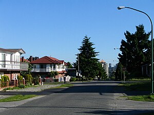
Willingdon Heights
Distance: Approx. 333 meters
Latitude and longitude: 49.276,-123.014
Willingdon Heights is a neighbourhood in Burnaby, British Columbia, Canada. It is named after a major Burnaby thoroughfare Willingdon Avenue connecting North Burnaby with Kingsway and the Metrotown area in the south. Willingdon Heights was developed significantly during construction spurred by the National Housing Act in 1944 that made mortgage money more widely available and provided joint loans for housing for veterans under the Integrated Housing Plan (IHP).
Spring Brook (Burnaby)
Distance: Approx. 1007 meters
Latitude and longitude: 49.26452,-123.016296
Spring Brook is one of many tributaries of Still Creek, an important stream in Burnaby, British Columbia, Canada. It runs north just east of Boundary Road and joins Still Creek just west of Gilmore Station. The area was once known to Burnaby residents as Broadview.
Thornton Tunnel
Distance: Approx. 829 meters
Latitude and longitude: 49.27952,-123.01843
The Thornton Tunnel is a freight railway tunnel in Burnaby, British Columbia, running under the Willingdon Heights and Vancouver Heights neighbourhoods. It was built in 1969 by Canadian National to connect Second Narrows Bridge to the main line in Willingdon, and is 3.4 km long. In the middle of the tunnel there is a fake house to cover up a ventilation shaft and fan systems to blend in a residential neighbourhood.
The Amazing Brentwood
Shopping mall in Burnaby, British Columbia, Canada
Distance: Approx. 1051 meters
Latitude and longitude: 49.268113,-123.000205
The Amazing Brentwood (previously Brentwood Town Centre and also referred to as Brentwood Mall) is a shopping mall in Burnaby, British Columbia, Canada. It is located in the Brentwood Park area of North Burnaby, at the intersection of Willingdon Avenue and Lougheed Highway, approximately 1.5 kilometres (0.9 mi) from the city of Vancouver.
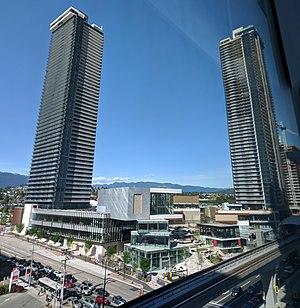
Two Gilmore Place
Residential/retail in British Columbia, Canada
Distance: Approx. 849 meters
Latitude and longitude: 49.26561111,-123.01361111
Two Gilmore Place is a skyscraper in Burnaby, British Columbia, Canada that is currently under construction. It is located at the intersection of Lougheed Highway and Gilmore Avenue, immediately north of Gilmore station. When completed in 2025, the Two Gilmore Place will become the tallest building in British Columbia at 215.8 metres (708 ft) tall.
Weather in this IP's area
few clouds
17 Celsius
16 Celsius
15 Celsius
18 Celsius
1015 hPa
81 %
1015 hPa
1006 hPa
10000 meters
3.6 m/s
210 degree
20 %
06:53:39
19:18:26