Country:
 Canada
Region:
City:
Latitude and Longitude:
Time Zone:
Postal Code:
IP information under different IP Channel
ip-api
Country
Region
City
ASN
Time Zone
ISP
Blacklist
Proxy
Latitude
Longitude
Postal
Route
IPinfo
Country
Region
City
ASN
Time Zone
ISP
Blacklist
Proxy
Latitude
Longitude
Postal
Route
MaxMind
Country
Region
City
ASN
Time Zone
ISP
Blacklist
Proxy
Latitude
Longitude
Postal
Route
Luminati
Country
CARegion
bc
City
burnaby
ASN
Time Zone
America/Vancouver
ISP
OXIO-ASN-01
Latitude
Longitude
Postal
db-ip
Country
Region
City
ASN
Time Zone
ISP
Blacklist
Proxy
Latitude
Longitude
Postal
Route
ipdata
Country
Region
City
ASN
Time Zone
ISP
Blacklist
Proxy
Latitude
Longitude
Postal
Route
Popular places and events near this IP address

Burnaby—New Westminster
Federal electoral district in British Columbia, Canada
Distance: Approx. 2072 meters
Latitude and longitude: 49.2134,-122.9472
Burnaby—New Westminster was a federal electoral district in British Columbia, Canada, that was represented in the House of Commons of Canada from 2004 to 2015.

Edmonds station (SkyTrain)
Metro Vancouver SkyTrain station
Distance: Approx. 2133 meters
Latitude and longitude: 49.212054,-122.959226
Edmonds is an at-grade station on the Expo Line of Metro Vancouver's SkyTrain rapid transit system. The station is located southwest of the intersection of Griffiths Drive and 18th Avenue, near Edmonds Street, south of Kingsway in the Edmonds area of Burnaby, British Columbia. SkyTrain's maintenance and storage facility serving both the Expo and Millennium lines is one block east of this station, linked to and from the main guideway by multiple switch tracks.
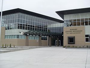
Burnaby Central Secondary School
High school in Burnaby, British Columbia, Canada
Distance: Approx. 1997 meters
Latitude and longitude: 49.24397222,-122.97513889
Burnaby Central Secondary School is a public high school in Burnaby, British Columbia. It is located across from Burnaby City Hall and is adjacent to Deer Lake Park. Burnaby Central is a part of Burnaby School District 41.

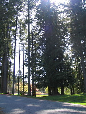
Burnaby Lake Regional Park
Regional park in British Columbia, Canada
Distance: Approx. 1453 meters
Latitude and longitude: 49.242427,-122.946067
Burnaby Lake is a lake located in Burnaby, British Columbia and is the focal geographic feature and namesake of Burnaby Lake Regional Park. The lake occupies 3.11 square kilometres (770 acres) of land, and is home to a large variety of wildlife. At least 70 species of birds make the lake and surrounding areas their home, and about 214 species of birds visit the lake throughout the year.
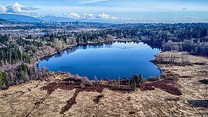
Deer Lake (British Columbia)
Distance: Approx. 1674 meters
Latitude and longitude: 49.236655,-122.977395
Deer Lake is a lake in central Burnaby, British Columbia, Canada. Deer Lake is home to a wide variety of flora and fauna and features a number of walking trails. These trails connect the lake and its surrounding forests and fields to a number of amenities, including a boat launch, picnic sites, a playground, washrooms, the Burnaby Art Gallery, Shadbolt Centre for the Arts, Burnaby Village Museum, and Century Gardens, as well as the surrounding community and long trails for walking.
Robert Burnaby Park
Public park in East Burnaby, Canada
Distance: Approx. 1639 meters
Latitude and longitude: 49.232676,-122.933578
Robert Burnaby Park is a 48 hectare public park in East Burnaby, just south of Burnaby Lake, located off Edmonds and 4th Street in British Columbia, Canada. It is open all year around from dawn to dusk. It has an extensive trail system, as well as tennis courts and a swimming pool in the cleared upper slope area.

Still Creek
Distance: Approx. 2119 meters
Latitude and longitude: 49.25,-122.95944444
Still Creek is a long stream flowing across Central Burnaby, British Columbia and into Burnaby Lake (which outflows into the Brunette River). Still Creek's path lies mainly through the industrial area which contributes to its high level of pollution, although through dedicated work of local volunteers the creek is slowly recovering. In 2006, the City of Burnaby approved a plan to reduce the amount of flooding in the Still Creek watershed (the low-lying area of Gilmore Avenue is heavily flooded every year) while improving fish and wildlife habitat.
C. W. Parker Carousel
Distance: Approx. 1364 meters
Latitude and longitude: 49.240718,-122.967623
The C. W. Parker Carousel is a carousel built in 1912 that is currently operating in the Burnaby Village Museum at Deer Lake Park in Burnaby, British Columbia. The carousel was built by the C. W. Parker Company and is also known as the Parker #119 and the Burnaby Centennial Parker Carousel. The carousel was the 119th such machine built by the C. W. Parker Company, earning it its "Parker #119" nickname.

Burnaby-Deer Lake
Provincial electoral district in British Columbia, Canada
Distance: Approx. 2002 meters
Latitude and longitude: 49.23333333,-122.98333333
Burnaby-Deer Lake is a provincial electoral district in British Columbia, Canada, established by the Electoral Districts Act, 2008. It was first contested in the 2009 general election, in which BC New Democrat (BC NDP) member Kathy Corrigan was elected its first MLA; Anne Kang, also a BC NDP politician, won the seat in 2017 after Corrigan decided not to run for re-election that year. Under the 2021 British Columbia electoral redistribution, the majority of the riding will reallocated to the new, larger district of Burnaby Centre, with the southwestern portion being redistributed to Burnaby South-Metrotown.
Edmonds, Burnaby
Neighbourhood of Burnaby in British Columbia, Canada
Distance: Approx. 1369 meters
Latitude and longitude: 49.21944444,-122.95
Edmonds is a neighbourhood in the southeast of Burnaby, British Columbia, Canada. It is one of the city's four officially designated town centres. The area is served by the Expo Line of the SkyTrain via Edmonds station.
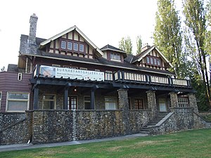
Burnaby Art Gallery
Art museum in British Columbia, Canada
Distance: Approx. 1566 meters
Latitude and longitude: 49.241,-122.9713
The Burnaby Art Gallery (abbreviated as BAG) is an art museum in Burnaby, British Columbia, Canada. The museum is located on the northern periphery of Deer Lake Park, situated off of Deer Lake Avenue. The museum occupies Fairacres Mansion, designated as a historic site by the municipal and provincial governments.

Robert Burnaby Park Disc Golf Course
Disc golf course in British Columbia, Canada
Distance: Approx. 1766 meters
Latitude and longitude: 49.23547222,-122.93263889
Robert Burnaby Park Disc Golf Course is a 10-hole disc golf course located in Burnaby, British Columbia, Canada. The course was designed by Jim Brown in 1999. It is one of only a handful of disc golf courses in the Vancouver area.
Weather in this IP's area
few clouds
16 Celsius
16 Celsius
15 Celsius
17 Celsius
1015 hPa
80 %
1015 hPa
1003 hPa
10000 meters
3.6 m/s
210 degree
20 %
06:53:26
19:18:12