Country:
Region:
City:
Latitude and Longitude:
Time Zone:
Postal Code:
IP information under different IP Channel
ip-api
Country
Region
City
ASN
Time Zone
ISP
Blacklist
Proxy
Latitude
Longitude
Postal
Route
Luminati
Country
Region
qc
City
montreal
ASN
Time Zone
America/Toronto
ISP
OXIO-ASN-01
Latitude
Longitude
Postal
IPinfo
Country
Region
City
ASN
Time Zone
ISP
Blacklist
Proxy
Latitude
Longitude
Postal
Route
db-ip
Country
Region
City
ASN
Time Zone
ISP
Blacklist
Proxy
Latitude
Longitude
Postal
Route
ipdata
Country
Region
City
ASN
Time Zone
ISP
Blacklist
Proxy
Latitude
Longitude
Postal
Route
Popular places and events near this IP address

Île Bizard
Island in Montreal, Quebec, Canada
Distance: Approx. 2239 meters
Latitude and longitude: 45.48333333,-73.9
Île Bizard is an island near the Island of Montreal in the Hochelaga Archipelago region. It is one of the three populated islands within the city of Montreal, along with the Island of Montreal and Nuns' Island (Île des Soeurs). The island is served by buses 207 and 407.

Pierrefonds—Dollard
Federal electoral district in Quebec, Canada
Distance: Approx. 2142 meters
Latitude and longitude: 45.4941,-73.8503
Pierrefonds—Dollard is a federal electoral district in Quebec, Canada, that has been represented in the House of Commons of Canada since 1988. Its population was 108,587 at the 2016 Canadian Census. This riding occupies the northwest part of the Island of Montreal on Lac des Deux-Montagnes and Rivière des Prairies.
Pierrefonds, Quebec
Former city in Quebec, Canada
Distance: Approx. 1925 meters
Latitude and longitude: 45.46666667,-73.88333333
Pierrefonds (Quebec French pronunciation: [pjaɛ̯ʁˈfõ]) is a former city in southwestern Quebec, Canada. It is located along the Rivière des Prairies on the northwestern part of the Island of Montreal (part of what is colloquially called the West Island). It was merged into Montreal on January 1, 2002, and is today part of the borough of Pierrefonds-Roxboro.

L'Île-Bizard, Quebec
Former city in Quebec, Canada
Distance: Approx. 913 meters
Latitude and longitude: 45.487417,-73.879917
L'Île-Bizard is a former municipality current borough located on Île Bizard, an island northwest of the Island of Montreal. It was originally incorporated as a municipality on 1 July 1855 as Paroisse de Saint-Raphael-de l'Ile-Bizard. On 1 January 2002, it was merged into the City of Montreal as part of the borough of L'Île-Bizard–Sainte-Geneviève.
Pierrefonds Community High School
Public middle and high school in Pierrefonds, Quebec, Canada
Distance: Approx. 2264 meters
Latitude and longitude: 45.49333333,-73.8475
Pierrefonds Community High School (often abbreviated as PCHS), is a non-denominational, English speaking educational facility located in the Pierrefonds-Roxboro borough of Montreal, Quebec, Canada with an enrollment capacity of approximately 1,200 students, in grades 7 through 11. It operates within the Lester B. Pearson School Board and has functioned as a secondary school since 1971. Having been originally named Pierrefonds Comprehensive High School, the slight name variation was added after the merge with Riverdale High School in 2019.

Sainte-Geneviève, Quebec
Neighbourhood in Montreal, Quebec, Canada
Distance: Approx. 628 meters
Latitude and longitude: 45.48502778,-73.86480556
Sainte-Geneviève was a municipality located on the Island of Montreal in southwestern Quebec, Canada. It is now part of the Borough of L'Île-Bizard–Sainte-Geneviève in the City of Montreal, created on January 1, 2002. The municipality, a small village populated by traditional Quebec-style dwellings and colonial mansions, is located on the north-west shore of the Island of Montreal along Gouin Boulevard, overlooking the Rivière des Prairies and across from Île Bizard located to the north.

L'Île-Bizard–Sainte-Geneviève
Borough of Montreal in Quebec, Canada
Distance: Approx. 396 meters
Latitude and longitude: 45.483055,-73.87615
L'Île-Bizard–Sainte-Geneviève (French pronunciation: [lil bizaʁ sɛ̃t ʒənvjɛv]) is a borough (arrondissement) of the city of Montreal.

Église Sainte-Geneviève (Montreal)
Distance: Approx. 218 meters
Latitude and longitude: 45.48,-73.8725
The Église Sainte-Geneviève (Church of St. Genevieve) is a parish church located in the former village of Sainte-Geneviève, Québec (now part of Montreal) on the north-west shore of the Island of Montreal overlooking the Rivière des Prairies. Its affiliation is Roman Catholic and it is administered under the Diocese of Montreal by La Paroisse Sainte-Geneviève de Pierrefonds, founded by Antoine Faucon in 1741.
Emmanuel Christian School, Quebec
Distance: Approx. 1797 meters
Latitude and longitude: 45.48666667,-73.84944444
Emmanuel Christian School (EMCS) is a Christian private elementary and high school located in Dollard-des-Ormeaux, Quebec, a city of Greater Montreal. Emmanuel Christian School bases its educational and religious values primarily on Evangelical Protestant principles. However, the diversity of the staff is typically free to express their values regardless of denomination.
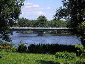
Jacques Bizard Bridge
Bridge in Quebec and Sainte-Geneviève, Quebec
Distance: Approx. 686 meters
Latitude and longitude: 45.4875,-73.86805556
Jacques Bizard Bridge is a bridge that crosses the Rivière des Prairies and connects the island of Île Bizard to Montreal Island. The existing bridge was built in 1966 and carries three lanes of Jacques Bizard Boulevard, including one reversible lane. In 2008 it was widened to accommodate a bicycle path.
Collège Gérald-Godin
Public college in Montréal, Quebec
Distance: Approx. 323 meters
Latitude and longitude: 45.483146,-73.86773
Cégep Gérald-Godin is a French-language public college located in Sainte-Geneviève, Montreal, Quebec, Canada. It is the first and only French-language public college on the West Island of Montreal. It is located on Gouin Boulevard overlooking the Rivière des Prairies.
Pierrefonds Boulevard
Distance: Approx. 795 meters
Latitude and longitude: 45.482731,-73.861307
Pierrefonds Boulevard is an east-west boulevard in the northwest of the Island of Montreal, or the northern part of West Island. It runs mostly through the borough of Pierrefonds-Roxboro.
Weather in this IP's area
broken clouds
11 Celsius
10 Celsius
10 Celsius
11 Celsius
1007 hPa
70 %
1007 hPa
1003 hPa
10000 meters
8.75 m/s
15.95 m/s
280 degree
75 %
06:45:25
16:33:11
