Country:
 Canada
Region:
City:
Latitude and Longitude:
Time Zone:
Postal Code:
IP information under different IP Channel
ip-api
Country
Region
City
ASN
Time Zone
ISP
Blacklist
Proxy
Latitude
Longitude
Postal
Route
IPinfo
Country
Region
City
ASN
Time Zone
ISP
Blacklist
Proxy
Latitude
Longitude
Postal
Route
MaxMind
Country
Region
City
ASN
Time Zone
ISP
Blacklist
Proxy
Latitude
Longitude
Postal
Route
Luminati
Country
CARegion
qc
City
saintegenevieve
ASN
Time Zone
America/Toronto
ISP
OXIO-ASN-01
Latitude
Longitude
Postal
db-ip
Country
Region
City
ASN
Time Zone
ISP
Blacklist
Proxy
Latitude
Longitude
Postal
Route
ipdata
Country
Region
City
ASN
Time Zone
ISP
Blacklist
Proxy
Latitude
Longitude
Postal
Route
Popular places and events near this IP address

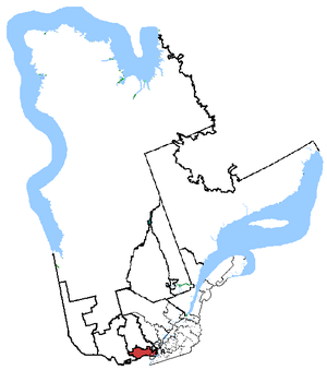
Saint-Eustache, Quebec
City in Quebec, Canada
Distance: Approx. 3533 meters
Latitude and longitude: 45.57,-73.9
Saint-Eustache (French pronunciation: [sɛ̃t‿østaʃ] ) is an off-island suburb of Montreal, in western Quebec, Canada, west of Montreal on the north shore of the Rivière des Mille Îles. It is located 35 km (22 mi) northwest of Montreal.
Argenteuil—Papineau—Mirabel
Federal electoral district in Quebec, Canada
Distance: Approx. 5128 meters
Latitude and longitude: 45.6,-74
Argenteuil—Papineau—Mirabel (formerly known as Argenteuil, Argenteuil—Papineau and Argenteuil—Deux-Montagnes) was a federal electoral district in Quebec, Canada, that was represented in the House of Commons of Canada from 1867 to 2015.

Rivière-des-Mille-Îles (electoral district)
Federal electoral district in Quebec, Canada
Distance: Approx. 6015 meters
Latitude and longitude: 45.602,-73.878
Rivière-des-Mille-Îles (formerly known as Saint-Eustache—Sainte-Thérèse) is a federal electoral district in Quebec, Canada, that has been represented in the House of Commons of Canada since 1997.

Deux-Montagnes station
Railway station in Quebec, Canada
Distance: Approx. 4137 meters
Latitude and longitude: 45.54555556,-73.91222222
Deux-Montagnes station is a future terminus station of the Réseau express métropolitain (REM) in Deux-Montagnes, Quebec, Canada. REM service at the station is scheduled to begin in the fourth quarter of 2024. The station will serve as the terminus of the Deux-Montagnes branch of the REM. Until the end of 2020, Deux-Montagnes was a commuter rail station operated by Exo and was the northern terminus of the Deux-Montagnes line.

Area codes 450, 579, and 354
Telephone area codes for the suburbs of Montreal
Distance: Approx. 3925 meters
Latitude and longitude: 45.61,-73.94
Area codes 450, 579, and 354 are telephone area codes in the North American Numbering Plan in the Canadian province of Quebec, encompassing the off-island suburbs of Montreal, as well as the rest of the Montérégie region southward to the border with New York state. Among the cities in the numbering plan area are Laval, Longueuil, Terrebonne, Saint-Jean-sur-Richelieu, Brossard, Repentigny, Saint-Jérôme, Granby, Blainville and Saint-Hyacinthe. Area code 450 is also shared by several small communities in an adjacent part of Ontario: some landline customers in Chute-à-Blondeau (East Hawkesbury), near Pointe-Fortune use numbers from the Rigaud exchange 451.
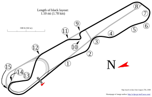
Autodrome Saint-Eustache
Distance: Approx. 1390 meters
Latitude and longitude: 45.57333333,-73.9625
The Autodrome Saint-Eustache was a motor sport complex in Saint-Eustache, Quebec, Canada. Established in 1965, it contained a 0.40 mi (0.64 km) paved oval and a 1.10 mi (1.77 km) paved road course with hot pits, grandstands and services. The oval circuit hosted NASCAR Whelen All-American Series weekly racing, with drivers racing for both the province (Quebec) and the rest of North America.
Deux-Montagnes (provincial electoral district)
Provincial electoral district in Quebec, Canada
Distance: Approx. 1722 meters
Latitude and longitude: 45.59,-73.94
Deux-Montagnes is a provincial electoral district in Quebec, Canada, that elects members to the National Assembly of Quebec. It consists of the cities of Deux-Montagnes and Saint-Eustache. It was created for the 1867 election (and an electoral district of that name existed earlier in the Legislative Assembly of the Province of Canada).
Sainte-Marthe-sur-le-Lac
City in Quebec, Canada
Distance: Approx. 5130 meters
Latitude and longitude: 45.53,-73.93
Sainte-Marthe-sur-le-Lac (French pronunciation: [sɛ̃t maʁt syʁ lə lak], Sainte-Marthe on the Lake) is an off-island suburb of Montreal, in the Canadian province of Quebec, in the Deux-Montagnes Regional County Municipality, 40 km from Montreal. It is crossed from east to west by Route 344, commonly known as Oka Road. The town shares its borders with Deux-Montagnes to the east, Saint-Joseph-du-Lac to the west, the Lake of Two Mountains to the south, and Saint-Eustache to the north.
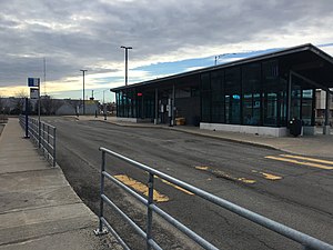
Terminus Saint-Eustache
Distance: Approx. 4319 meters
Latitude and longitude: 45.56152778,-73.89277778
Terminus Saint-Eustache is a bus terminus served by Réseau de transport métropolitain (RTM).

Grand-Moulin station
Railway station in Quebec, Canada
Distance: Approx. 6111 meters
Latitude and longitude: 45.53722222,-73.88777778
Grand-Moulin is a light rail station that will be operated by the Réseau express métropolitain in Deux-Montagnes, Quebec, Canada. It was served by the Deux-Montagnes line until the line closed in 2020.
Lake of Two Mountains High School
School in Deux-Montagnes, Quebec, Canada
Distance: Approx. 4480 meters
Latitude and longitude: 45.5411,-73.9136
Lake of Two Mountains High School (LTM; French: École secondaire Lake of Two Mountains) is an Anglophone public high school in Deux-Montagnes, Quebec in the Laurentides region. It is a part of the Sir Wilfrid Laurier School Board. The school's service area includes Deux Montagnes, Kanesatake, southern portions of Mirabel, Oka, Pointe-Calumet, Saint-Eustache, Saint-Placide, Ste-Marthe-sur-le-Lac, and St-Joseph-du-Lac.
École Polyvalente Deux-Montagnes
Distance: Approx. 4294 meters
Latitude and longitude: 45.5471,-73.9066
École Polyvalente Deux-Montagnes (PDM) is a Francophone secondary school in Deux-Montagnes, Quebec, Canada. It is a part of the Commission scolaire de la Seigneurie-des-Mille-Îles (CSSMI). With a little over 2,000 students, PDM is one of the largest comprehensive ("polyvalente") high schools in Quebec.
Weather in this IP's area
overcast clouds
19 Celsius
20 Celsius
18 Celsius
21 Celsius
1017 hPa
92 %
1017 hPa
1012 hPa
10000 meters
1.27 m/s
1.32 m/s
304 degree
100 %
06:38:27
19:01:12