Country:
 Canada
Region:
City:
Latitude and Longitude:
Time Zone:
Postal Code:
IP information under different IP Channel
ip-api
Country
Region
City
ASN
Time Zone
ISP
Blacklist
Proxy
Latitude
Longitude
Postal
Route
IPinfo
Country
Region
City
ASN
Time Zone
ISP
Blacklist
Proxy
Latitude
Longitude
Postal
Route
MaxMind
Country
Region
City
ASN
Time Zone
ISP
Blacklist
Proxy
Latitude
Longitude
Postal
Route
Luminati
Country
CARegion
qc
City
saintgabrieldevalcartier
ASN
Time Zone
America/Toronto
ISP
OXIO-ASN-01
Latitude
Longitude
Postal
db-ip
Country
Region
City
ASN
Time Zone
ISP
Blacklist
Proxy
Latitude
Longitude
Postal
Route
ipdata
Country
Region
City
ASN
Time Zone
ISP
Blacklist
Proxy
Latitude
Longitude
Postal
Route
Popular places and events near this IP address
Val-Bélair, Quebec City
Former city amalgamated into Quebec City
Distance: Approx. 7650 meters
Latitude and longitude: 46.86666667,-71.43333333
Val-Bélair is a former city located near the St. Lawrence River in Quebec, Canada. It was amalgamated into Quebec City on January 1, 2002.
CFB Valcartier
Military base near Quebec City, Canada
Distance: Approx. 4254 meters
Latitude and longitude: 46.90277778,-71.50361111
2nd Canadian Division Support Base Valcartier (2 CDSB Valcartier), formerly known as and commonly referred to as Canadian Forces Base Valcartier (CFB Valcartier), is a Canadian Forces base located in the municipality of Saint-Gabriel-de-Valcartier, 8 nautical miles (15 km; 9.2 mi) north northwest of Quebec City, Quebec, Canada. The 2nd Canadian Division is stationed at the base, comprising the 5 Canadian Mechanized Brigade Group and the 2nd Canadian Division Support Group.
Lac-Saint-Charles, Quebec City
Distance: Approx. 7372 meters
Latitude and longitude: 46.91,-71.375
Lac-Saint-Charles is a former city in Quebec and is now a district of the Quebec City borough of La Haute-Saint-Charles. The population as of the Canada 2011 Census was 9,886. It existed from 1946 until being amalgamated into Quebec City in 2002.

La Haute-Saint-Charles, Quebec City
Borough in Quebec, Canada
Distance: Approx. 8525 meters
Latitude and longitude: 46.89027778,-71.37222222
La Haute-Saint-Charles is a borough of Quebec City. Population (2006): 74,070. It comprises Lac-Saint-Charles, Saint-Émile, Neufchâtel, Loretteville and Val-Bélair.

Shannon, Quebec
City in Quebec, Canada
Distance: Approx. 6572 meters
Latitude and longitude: 46.88333333,-71.51666667
Shannon is a city in Quebec, Canada, along the Jacques-Cartier River northwest of Quebec City. It was formed in December 1946 when it separated from the territory of Sainte-Catherine-de-Fossambault, following protests of this part of the population against the municipal taxes. The community was founded by Irish immigrants and once contained a substantial English-speaking population, though today it is chiefly French-speaking.

Ice Hotel (Quebec)
Distance: Approx. 1526 meters
Latitude and longitude: 46.943966,-71.475037
The Ice Hotel (French: Hôtel de Glace) in Saint-Gabriel-de-Valcartier, Quebec, Canada is the oldest ice hotel in North America.

Lac-Delage
City in Quebec, Canada
Distance: Approx. 6404 meters
Latitude and longitude: 46.96666667,-71.4
Lac-Delage is a town in the Capitale-Nationale region of Quebec, Canada, located on the eponymous Lake Delage.
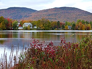
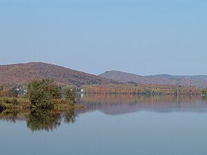
Saint-Gabriel-de-Valcartier
Municipality in Quebec, Canada
Distance: Approx. 204 meters
Latitude and longitude: 46.93333333,-71.46666667
Saint-Gabriel-de-Valcartier (French pronunciation: [sɛ̃ ɡabʁijɛl də valkaʁtje]) is a municipality in the Capitale-Nationale region of Quebec, Canada, located in the Jacques-Cartier River valley.
Lake Saint-Charles
Lake in Quebec, Canada
Distance: Approx. 6135 meters
Latitude and longitude: 46.94111111,-71.38722222
Lake Saint-Charles (French: Lac Saint-Charles) is a lake located in the Capitale-Nationale region of Quebec, Canada. It is located partially within the Quebec City borough of La Haute-Saint-Charles (section West) and partially within the united township municipality of Stoneham-et-Tewkesbury (section East). Lake Saint-Charles is the source of the Saint-Charles River.
Noire River (rivière des Hurons)
Tributary of rivière des Hurons, in Quebec, Canada
Distance: Approx. 6250 meters
Latitude and longitude: 46.95361111,-71.39111111
The rivière Noire (English: Black River) is a tributary of the rivière des Hurons, flowing in the heart of the municipality of the townships of Stoneham-et-Tewkesbury, located north of the city of Quebec, in the La Jacques-Cartier Regional County Municipality, in the administrative region of the Capitale-Nationale, in the province of Quebec, in Canada. The Black River valley is mainly served by route 175 and boulevard Talbot. The surface of the Black River (except the rapids areas) is generally frozen from the beginning of December to the end of March; however, safe circulation on the ice is generally done from the end of December to the beginning of March.
La Petite Rivière (Nelson River tributary)
River in Quebec, Canada
Distance: Approx. 2141 meters
Latitude and longitude: 46.92389,-71.44083
La Petite Rivière is a tributary stream of the Nelson River, flowing in the administrative region of Capitale-Nationale, in the province from Quebec, to Canada. The course of the river crosses: Quebec City over only a hundred metres; the municipality of Lac-Saint-Charles over only a hundred metres; the municipality of Saint-Gabriel-de-Valcartier in the La Jacques-Cartier Regional County Municipality. This watercourse is part of the watershed of the Saint-Charles River.

Tourbière-de-Shannon Ecological Reserve
Distance: Approx. 6637 meters
Latitude and longitude: 46.90246,-71.542931
The Tourbière-de-Shannon Ecological Reserve (French: Réserve écologique de la Tourbière-de-Shannon) is a strictly protected ecological reserve of Quebec, Canada.
Weather in this IP's area
few clouds
16 Celsius
16 Celsius
14 Celsius
18 Celsius
1018 hPa
92 %
1018 hPa
993 hPa
10000 meters
20 %
06:28:05
18:51:44