Country:
 Canada
Region:
City:
Latitude and Longitude:
Time Zone:
Postal Code:
IP information under different IP Channel
ip-api
Country
Region
City
ASN
Time Zone
ISP
Blacklist
Proxy
Latitude
Longitude
Postal
Route
IPinfo
Country
Region
City
ASN
Time Zone
ISP
Blacklist
Proxy
Latitude
Longitude
Postal
Route
MaxMind
Country
Region
City
ASN
Time Zone
ISP
Blacklist
Proxy
Latitude
Longitude
Postal
Route
Luminati
Country
CARegion
qc
City
montreal
ASN
Time Zone
America/Toronto
ISP
OXIO-ASN-01
Latitude
Longitude
Postal
db-ip
Country
Region
City
ASN
Time Zone
ISP
Blacklist
Proxy
Latitude
Longitude
Postal
Route
ipdata
Country
Region
City
ASN
Time Zone
ISP
Blacklist
Proxy
Latitude
Longitude
Postal
Route
Popular places and events near this IP address
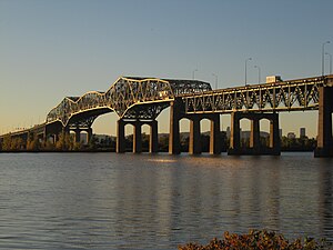
Champlain Bridge (Montreal, 1962–2019)
Bridge in Quebec, Canada
Distance: Approx. 3625 meters
Latitude and longitude: 45.46861111,-73.5175
The Champlain Bridge (French: Pont Champlain) was a steel truss cantilever bridge with approach viaducts constructed of prestressed concrete beams supporting a prestressed concrete deck paved with asphalt. Opened in 1962, the bridge crossed the Saint Lawrence River, connecting the Island of Montreal to its South Shore suburbs. Together with the Jacques Cartier Bridge, it was administered by the Jacques Cartier and Champlain Bridges Incorporated (JCCBI), a Canadian Crown Corporation which reports to Housing, Infrastructure and Communities Canada.

Brossard
City in Quebec, Canada
Distance: Approx. 3519 meters
Latitude and longitude: 45.46666667,-73.45
Brossard ( bross-AR, BROSS-ard, French: [bʁɔsaʁ], locally [bʁɔsɑːʁ, bʁɔsɑɔ̯ʁ]) is a municipality in the Montérégie region of Quebec, Canada and is part of the Greater Montreal area. According to the 2021 census, Brossard's population was 91,525. It shares powers with the urban agglomeration of Longueuil and was a borough of the municipality of Longueuil from 2002 to 2006.
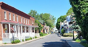
La Prairie, Quebec
City in Quebec, Canada
Distance: Approx. 3150 meters
Latitude and longitude: 45.42,-73.5
La Prairie (French pronunciation: [la pʁɛʁi]) is an off-island suburb (south shore) of Montreal, in southwestern Quebec, Canada, at the confluence of the Saint-Jacques River and the Saint Lawrence River in the Regional County Municipality of Roussillon. The population as of the Canada 2021 Census was 26,406.
Collège Jean de la Mennais
School in La Prairie, Quebec, Canada
Distance: Approx. 3638 meters
Latitude and longitude: 45.41333333,-73.48277778
Collège Jean de la Mennais is a French private mixed secondary school on the South Shore of Montreal, Québec, Canada at 870 Chemin de Saint-Jean in the municipality of La Prairie. As of 2007, the school had about 1750 elementary and high school students. Collège Jean de la Mennais was once directed by religious brothers, although today it is directed by a secular administration.

South Shore (Montreal)
Place in Quebec, Canada
Distance: Approx. 2173 meters
Latitude and longitude: 45.435,-73.46111111
The South Shore (French: Rive-Sud) is the general term for the suburbs of Montreal, Quebec located on the southern shore of the Saint Lawrence River opposite the Island of Montreal. The South Shore is located within the Quebec administrative region of Montérégie. The largest city on the South Shore area is Longueuil.

Parc écologique des Sansonnets
Distance: Approx. 808 meters
Latitude and longitude: 45.451378,-73.477153
Parc écologique des Sansonnets or Parc Sansonnets (English: Ecological Park of the Starlings) is a forested natural reserve located in Brossard, Quebec. As a rare example of a mature deciduous forest in the suburbs of Montreal, it covers 14.1 acres (57,000 m2) in the S section of Brossard and is located at the southeast corner of the intersection of Saguenay Avenue and Pelletier Boulevard (adjacent to the residential streets of Sorel and Suède and Saint-Laurent Primary School). Numerous footpaths start from these major streets to provide access to the inner parts of this park.
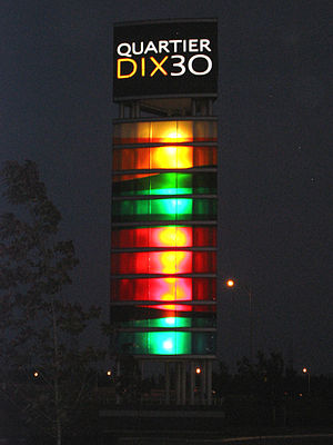
Quartier DIX30
Shopping mall in Quebec, Canada
Distance: Approx. 3791 meters
Latitude and longitude: 45.443031,-73.43575
Quartier DIX30 (also simply known as Dix 30 in French) is a commercial lifestyle centre located in Brossard, Quebec. It is considered Canada's first lifestyle centre and occupies an area of 2,746,063 sq ft (255,117.6 m2) in the L section of Brossard. Quartier DIX30 was designed to emulate an urban or downtown shopping experience with boutiques and to meet the needs of suburban dwellers living on the South Shore of Montreal.
Champlain Mall
Shopping mall
Distance: Approx. 3224 meters
Latitude and longitude: 45.47330833,-73.47035
The Champlain Mall (French: Mail Champlain) is a shopping mall located in Brossard, Quebec, Canada at the intersection of Taschereau Boulevard and Lapinière Boulevard. Champlain Mall is named in honour of Samuel de Champlain but references the Champlain Bridge that was built 13 years prior to the mall's opening. Champlain Mall is strategically located in Brossard: on the South Shore's longest commercial artery Taschereau Boulevard (Quebec Route 134), near Autoroute 10 and adjacent to Terminus Brossard-Panama.
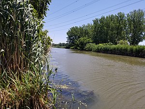
Saint Jacques River
River in Quebec, Canada
Distance: Approx. 1675 meters
Latitude and longitude: 45.431693,-73.490725
Saint-Jacques River is a river in southwestern Quebec, Canada that drains the Saint Lawrence Lowlands. It flows in a general south to north direction, from the area around Saint-Jacques-le-Mineur (in Les Jardins-de-Napierville) to its mouth in the Saint Lawrence River, at the border between the cities of Brossard and La Prairie.

Fort Laprairie
Building in Quebec, Canada
Distance: Approx. 2969 meters
Latitude and longitude: 45.42083333,-73.49666667
Fort Laprairie was constructed in 1687, and served as a military fort in New France until 1713. The fort was attacked by English and Dutch colonists under Major Pieter Schuyler on August 11, 1691, but resisted to the invaders. The site where the fort had once stood was designated as a National Historic Site of Canada in 1921.

Panama station
Rapid transit station in Quebec, Canada
Distance: Approx. 2682 meters
Latitude and longitude: 45.4675,-73.46861111
Panama station is a Réseau express métropolitain (REM) station in the city of Brossard, Quebec, Canada. It is operated by CDPQ Infra and serves as a station on the South Shore branch of the REM. The station opened on 31 July 2023. The station replaced the Panama bus terminus and functions as a large transit hub for the cities of Longueuil and Brossard.

Samuel-De Champlain Bridge
Bridge over the Saint Lawrence River in Montreal, Canada
Distance: Approx. 3614 meters
Latitude and longitude: 45.46944444,-73.51611111
The Samuel-De Champlain Bridge, colloquially known as the Champlain Bridge, is a cable-stayed bridge design by architect Poul Ove Jensen and built to replace the original Champlain Bridge over the Saint Lawrence River in Quebec, between Nuns' Island in the borough of Verdun in Montreal and the suburban city of Brossard on the South Shore. A second, connected bridge links Nuns' Island to the main Island of Montreal. It is the busiest bridge in the country with more cars flowing into it than any other bridge.
Weather in this IP's area
clear sky
20 Celsius
20 Celsius
18 Celsius
21 Celsius
1017 hPa
76 %
1017 hPa
1015 hPa
10000 meters
0.89 m/s
0.89 m/s
173 degree
06:36:38
18:59:19