Country:
Region:
City:
Latitude and Longitude:
Time Zone:
Postal Code:
IP information under different IP Channel
ip-api
Country
Region
City
ASN
Time Zone
ISP
Blacklist
Proxy
Latitude
Longitude
Postal
Route
Luminati
Country
Region
qc
City
montreal
ASN
Time Zone
America/Toronto
ISP
OXIO-ASN-01
Latitude
Longitude
Postal
IPinfo
Country
Region
City
ASN
Time Zone
ISP
Blacklist
Proxy
Latitude
Longitude
Postal
Route
db-ip
Country
Region
City
ASN
Time Zone
ISP
Blacklist
Proxy
Latitude
Longitude
Postal
Route
ipdata
Country
Region
City
ASN
Time Zone
ISP
Blacklist
Proxy
Latitude
Longitude
Postal
Route
Popular places and events near this IP address

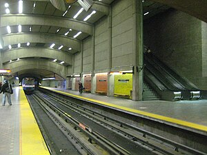
Place-Saint-Henri station
Montreal Metro station
Distance: Approx. 386 meters
Latitude and longitude: 45.47722222,-73.58666667
Place-Saint-Henri station is a Montreal Metro station in the borough of Le Sud-Ouest in Montreal, Quebec, Canada. It is operated by the Société de transport de Montréal (STM) and serves the Orange Line. It is located in the Saint-Henri neighbourhood.
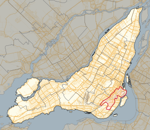
Westmount—St. Henri
Federal electoral district in Quebec, Canada
Distance: Approx. 953 meters
Latitude and longitude: 45.482,-73.584
Westmount—St. Henri was a federal electoral district in Quebec, Canada, that was represented in the House of Commons of Canada from 1917 to 1925. This riding was created in 1914 from parts of Hochelaga riding.

Saint-Henri, Montreal
Neighbourhood in Montreal, Quebec, Canada
Distance: Approx. 382 meters
Latitude and longitude: 45.47716,-73.58651
Saint-Henri is a neighbourhood in southwestern Montreal, Quebec, Canada, in the borough of Le Sud-Ouest. Saint-Henri is bounded to the east by Atwater Avenue, to the west by the town of Montreal West, to the north by Autoroute Ville-Marie (Route 136), and to the south by the Lachine Canal.

Atwater Market
Building in Atwater Street, Montreal
Distance: Approx. 1056 meters
Latitude and longitude: 45.479452,-73.57663
Atwater Market is a market hall located in the Saint-Henri area of Montreal, Quebec, Canada. It opened in 1933. The interior market is home to many butchers and the Première Moisson bakery and restaurant.

Saint-Henri–Sainte-Anne
Provincial electoral district in Quebec, Canada
Distance: Approx. 905 meters
Latitude and longitude: 45.48,-73.58
Saint-Henri–Sainte-Anne is a provincial electoral district in the Montreal region of Quebec, Canada that elects members to the National Assembly of Quebec. It comprises all of the Le Sud-Ouest borough of Montreal. It was created for the 1994 election from parts of Saint-Henri and Sainte-Anne electoral districts.
Saint-Henri (provincial electoral district)
Former provincial electoral district in Quebec, Canada
Distance: Approx. 313 meters
Latitude and longitude: 45.476,-73.585
Saint-Henri was a provincial electoral district in the Montreal region of Quebec, Canada. It corresponded to Saint-Henri neighbourhood and surrounding area in Montreal. It was created for the 1966 election from part of Montréal–Saint-Henri.

Westmount station
Railway station in Montreal, Quebec, Canada
Distance: Approx. 884 meters
Latitude and longitude: 45.47666667,-73.59805556
The Westmount station (French: Gare de Westmount) is a disused railway station in the city of Westmount, Quebec, Canada. Its address is 4848 Saint Catherine Street West at the bottom of Victoria Avenue in the Victoria Village neighbourhood. It was designed for the Canadian Pacific Railway by the company architect, W.S. Painter, and was completed in 1907.

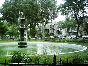
Sir George-Étienne Cartier Square
Distance: Approx. 93 meters
Latitude and longitude: 45.473515,-73.586378
Sir George-Étienne Cartier Square (officially in French: square Sir-George-Étienne-Cartier) is a town square in Montreal, Quebec, Canada. It is located in the Saint-Henri neighbourhood of the Southwest borough. It is a small rectangular square with a fountain in the middle, woods in the northern part and a pool in the southern part.
Saint Henri Square
Town square in Montreal, Canada
Distance: Approx. 705 meters
Latitude and longitude: 45.48008,-73.58629
Saint Henri Square (French: Square Saint-Henri), known officially as Saint Henri Park (French: Parc Saint-Henri)) is a town square in Montreal, Quebec, Canada. It is centrally located in the Saint Henri neighbourhood of the Le Sud-Ouest borough. The square is bordered by Saint Antoine Street West to the north, Agnes Street to the west, Place Guay to the south and Laporte Avenue to the east.
Canada Malting Silos, Montreal
Abandoned malting facility in Canada
Distance: Approx. 583 meters
Latitude and longitude: 45.4686,-73.58839
Canadian Malting Silos is an abandoned malting factory located in the Saint-Henri neighbourhood of Montreal, Canada.

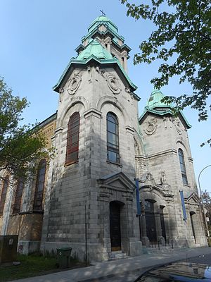
Saint-Henri Church
Church in Quebec, Canada
Distance: Approx. 632 meters
Latitude and longitude: 45.47947222,-73.58722222
Saint-Henri Church (French: Église de Saint-Henri) is a former Roman Catholic church in Montreal, Quebec, Canada. It is located at 872 du Couvent Street in the Saint-Henri neighbourhood of the Southwest borough.

Pink House (Montreal)
Distance: Approx. 583 meters
Latitude and longitude: 45.4686,-73.58839
The Pink House (French: Maison Rose) is a guerrilla art project in Montreal, Canada, where unknown individuals ascended a grain silo attached to an abandoned factory, and decorated the control cabin there to resemble a house. Located on the site of the former Canada Malting factory alongside the Lachine Canal the House was first painted bright pink in October 2019. Subsequent additions have included green shutters, curtains, window boxes, a Christmas tree, and a giant gift box labeled "À: Saint-Henri, De : Little Pink" ("To St-Henri, from: Little Pink"); as well, the adjacent control cabin has been painted bright red.
Weather in this IP's area
broken clouds
11 Celsius
10 Celsius
10 Celsius
12 Celsius
1006 hPa
64 %
1006 hPa
1004 hPa
10000 meters
9.77 m/s
14.4 m/s
290 degree
75 %
06:44:16
16:32:04

