Country:
 Canada
Region:
City:
Latitude and Longitude:
Time Zone:
Postal Code:
IP information under different IP Channel
ip-api
Country
Region
City
ASN
Time Zone
ISP
Blacklist
Proxy
Latitude
Longitude
Postal
Route
IPinfo
Country
Region
City
ASN
Time Zone
ISP
Blacklist
Proxy
Latitude
Longitude
Postal
Route
MaxMind
Country
Region
City
ASN
Time Zone
ISP
Blacklist
Proxy
Latitude
Longitude
Postal
Route
Luminati
Country
CARegion
qc
City
victoriaville
ASN
Time Zone
America/Toronto
ISP
OXIO-ASN-01
Latitude
Longitude
Postal
db-ip
Country
Region
City
ASN
Time Zone
ISP
Blacklist
Proxy
Latitude
Longitude
Postal
Route
ipdata
Country
Region
City
ASN
Time Zone
ISP
Blacklist
Proxy
Latitude
Longitude
Postal
Route
Popular places and events near this IP address
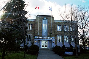
Victoriaville
City in Quebec, Canada
Distance: Approx. 4095 meters
Latitude and longitude: 46.05,-71.96666667
Victoriaville is a town in south-central Quebec, Canada, on the Nicolet River. Victoriaville is the seat of Arthabaska Regional County Municipality and a part of the Centre-du-Québec (Bois-Francs) region. It is formed by the 1993 merger of Arthabaska, Saint-Victoire-d'Arthabaska and Victoriaville, the name of the last being used for the merged town.
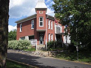
Arthabaska County, Quebec
Distance: Approx. 3513 meters
Latitude and longitude: 46,-72
Arthabaska County is an historical county founded in 1855 in central Quebec, Canada. Its county seat was Arthabaska and the main city was Victoriaville. It was bounded on the northeast by Mégantic County on the southeast Wolfe County, on the southwest by Drummond County and Richmond County and on the northwest by Nicolet County.
Colisée Desjardins
Arena in Victoriaville, Quebec, Canada
Distance: Approx. 4966 meters
Latitude and longitude: 46.05711389,-71.94486389
The Colisée Desjardins, formerly the Colisée des Bois-Francs, is a 3,420 capacity multi-purpose arena in Victoriaville, Quebec, Canada. It is home to the Victoriaville Tigres ice hockey team. The arena was built in 1980 and is also known as the Amphithéatre Gilbert-Perreault.
Warwick, Quebec
City in Quebec, Canada
Distance: Approx. 7326 meters
Latitude and longitude: 45.95,-71.98333333
Warwick is a small town north east of Montreal, located in Arthabaska county, Quebec, Canada. The town was incorporated in 1861 and named after the town of the same name in England. Up until 2014 the town hosted Quebec's annual summer cheese festival, which showcases many of the locally produced artisanal cheeses.
CFDA-FM
Radio station in Victoriaville, Quebec
Distance: Approx. 7107 meters
Latitude and longitude: 46.05277778,-71.88638889
CFDA-FM is a Canadian radio station, broadcasting an adult contemporary format at 101.9 FM in Victoriaville, Quebec. It shares the programming of sister station CKLD-FM in Thetford Mines. The stations air the same programming at all times, although both stations produce a portion of the shared broadcast schedule from separate studios.
Cégep de Victoriaville
Public college in Victoriaville, Quebec
Distance: Approx. 5294 meters
Latitude and longitude: 46.06013889,-71.94487778
Cégep de Victoriaville is a post-secondary institution (CEGEP, or junior college) in Victoriaville, Quebec, Canada.

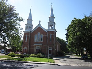
Saint-Christophe-d'Arthabaska
Parish municipality in Quebec, Canada
Distance: Approx. 6248 meters
Latitude and longitude: 46.03333333,-71.88333333
Saint-Christophe-d'Arthabaska is a parish municipality located in the Centre-du-Québec region of Quebec, Canada.
Saint-Albert, Quebec
Municipality in Quebec, Canada
Distance: Approx. 9732 meters
Latitude and longitude: 46,-72.08333333
Saint-Albert is a municipality located in the Centre-du-Québec region of Quebec, Canada.
Gosselin River (Nicolet River tributary)
River in Centre-du-Québec, Quebec (Canada)
Distance: Approx. 3345 meters
Latitude and longitude: 46.04,-71.93833
The Gosselin River (in French: rivière Gosselin) is a tributary of Nicolet River passing through Saint-Norbert-d'Arthabaska, Saint-Christophe d'Arthabaska and Victoriaville, in the regional county municipality (MRC) of Arthabaska Regional County Municipality, in the administrative region of Centre-du-Québec, in Quebec, in Canada. The Gosselin River sometimes flows in agricultural, forest and urban areas.
Lachance River
River in Centre-du-Québec, Quebec (Canada)
Distance: Approx. 6409 meters
Latitude and longitude: 46.06166,-71.91333
The Lachance river (in French: rivière Lachance) is a watercourse whose mouth flows into the Gosselin River, a tributary of the Nicolet River in the city of Victoriaville, in the Arthabaska Regional County Municipality (MRC), in the administrative region of Centre-du-Québec, in Quebec, in Canada. The Lachance River sometimes flows in agricultural and urban areas.
L'Abbé River (Bulstrode River tributary)
River in Centre-du-Québec, Quebec (Canada)
Distance: Approx. 7216 meters
Latitude and longitude: 46.07833,-71.96389
The L'Abbé River (in French: rivière L'Abbé) is a watercourse whose mouth flows into the Bulstrode River in the town of Victoriaville, in the Arthabaska Regional County Municipality (MRC), in the administrative region of Centre-du-Québec, in Quebec, in Canada. The L'Abbé river flows mainly in agricultural areas.
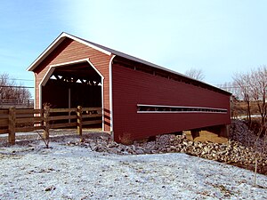
Joseph-Édouard Perrault Bridge
Bridge in Quebec, Canada
Distance: Approx. 7369 meters
Latitude and longitude: 45.95625,-72.006583
The Joseph-Édouard-Perrault bridge, formerly known as the Pont Perrault-Charbonneau, is a covered bridge located at Warwick, Quebec, Canada. Built in 1908, it was used for automobile traffic until 1957. It was classified historical monument in 1999.
Weather in this IP's area
overcast clouds
16 Celsius
16 Celsius
16 Celsius
17 Celsius
1018 hPa
84 %
1018 hPa
1001 hPa
10000 meters
1.32 m/s
1.27 m/s
144 degree
100 %
06:30:21
18:53:24