Country:
Region:
City:
Latitude and Longitude:
Time Zone:
Postal Code:
IP information under different IP Channel
ip-api
Country
Region
City
ASN
Time Zone
ISP
Blacklist
Proxy
Latitude
Longitude
Postal
Route
Luminati
Country
Region
qc
City
quebec
ASN
Time Zone
America/Toronto
ISP
OXIO-ASN-01
Latitude
Longitude
Postal
IPinfo
Country
Region
City
ASN
Time Zone
ISP
Blacklist
Proxy
Latitude
Longitude
Postal
Route
db-ip
Country
Region
City
ASN
Time Zone
ISP
Blacklist
Proxy
Latitude
Longitude
Postal
Route
ipdata
Country
Region
City
ASN
Time Zone
ISP
Blacklist
Proxy
Latitude
Longitude
Postal
Route
Popular places and events near this IP address

Charlesbourg, Quebec City
Borough of Quebec City in Canada
Distance: Approx. 1513 meters
Latitude and longitude: 46.867,-71.267
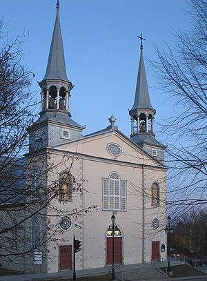
Charlesbourg is a borough of Quebec City, in the northeastern part of the city, west of the borough of Beauport.

Colisée de Québec
Multi-purpose arena in Quebec City
Distance: Approx. 2955 meters
Latitude and longitude: 46.83083333,-71.24638889
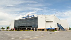
Colisée de Québec (later known as Colisée Pepsi, meaning "Pepsi Coliseum") was a multi-purpose arena located in Quebec City, Quebec. It was the home of the Quebec Nordiques from 1972 to 1995, during their time in the World Hockey Association and National Hockey League. It was also the home of the Quebec Remparts of the Quebec Major Junior Hockey League from 1999 until its closing in 2015.

Beauport—Limoilou
Federal electoral district in Quebec, Canada
Distance: Approx. 2992 meters
Latitude and longitude: 46.842,-71.221
Beauport—Limoilou is a federal electoral district in Quebec City, Quebec, Canada, that has been represented in the House of Commons of Canada since 2004. The riding was created in 2003 as "Beauport" from parts of Beauport—Montmorency—Côte-de-Beaupré—Île-d'Orléans, Quebec and Quebec East ridings. It was renamed "Beauport—Limoilou" after the 2004 election.
CHRC (AM)
Former radio station in Quebec City, Quebec
Distance: Approx. 2955 meters
Latitude and longitude: 46.83083333,-71.24638889
CHRC was a French language radio station located in Quebec City, Quebec, Canada. Known as Québec 800, the station had a news/talk/sports format. Founded in 1926, it was the oldest station in Quebec City at the time of its shutdown.

Jean-Lesage
Provincial electoral district in Quebec, Canada
Distance: Approx. 3290 meters
Latitude and longitude: 46.84166667,-71.21666667
Jean-Lesage is a provincial electoral district in the Capitale-Nationale region of Quebec, Canada that elects members to the National Assembly of Quebec. It consists of parts of the Beauport and La Cité-Limoilou boroughs of Quebec City. It was created for the 2003 election from most of the former Limoilou and part of Montmorency electoral districts.

Charlesbourg (provincial electoral district)
Provincial electoral district in Quebec, Canada
Distance: Approx. 1468 meters
Latitude and longitude: 46.86666667,-71.26666667
Charlesbourg is a provincial electoral district in the Capitale-Nationale region of Quebec, Canada that elects members to the National Assembly of Quebec. It consists of part of the Charlesbourg borough of Quebec City. It was created for the 1973 election from parts of Chauveau and Montmorency electoral districts.
Quebec County, Quebec
Distance: Approx. 591 meters
Latitude and longitude: 46.86,-71.26
Quebec County was a historic county in the province of Quebec, Canada. The county included the Quebec City metropolitan area and extended northwestward. The county seat was Loretteville.

Pavillon Guy-Lafleur
Distance: Approx. 3324 meters
Latitude and longitude: 46.8273,-71.248
The Pavillon Guy-Lafleur, formerly Pavillon de la Jeunesse, (1970-2024) is an indoor arena, in Quebec City, Quebec on the grounds of ExpoCité. It opened in 1931 as an amphitheatre to replace the Victoria Park Arena destroyed in 1943, it was referred to as Pavillon de l'agriculture (1931 to 1970) for use for agricultural displays for the provincial exhibition or Expo Quebec. Since the 1980s it has been used as a sports venue and has a capacity of 5,000 spectators.
Hôpital Saint-François d'Assise
Hospital in Quebec, Canada
Distance: Approx. 3481 meters
Latitude and longitude: 46.8279,-71.2366
Hôpital Saint-François d'Assise is one three teaching hospitals affiliated with the medical school of Université Laval and several specialized institutions in Quebec City, Quebec, Canada.

Videotron Centre
Indoor arena in Quebec City
Distance: Approx. 3136 meters
Latitude and longitude: 46.829,-71.248
Vidéotron Centre (French: Centre Vidéotron) is an indoor arena in Quebec City, Quebec, Canada. The 18,259-seat arena replaced Colisée Pepsi as Quebec City's primary venue for indoor events. The arena is primarily used for ice hockey, serving as the home arena of the Quebec Remparts of the QMJHL and has been prospected as a venue for a new or re-located National Hockey League team in Quebec City, and as part of a Winter Olympic Games bid.

ExpoCité
Distance: Approx. 3257 meters
Latitude and longitude: 46.828,-71.247
ExpoCité (formerly Parc de l'Exposition) is a multi-site entertainment complex located in the borough of La Cité-Limoilou, in downtown Quebec City. This is also the name of the corporation authorized by the City of Quebec to administer the site. ExpoCité was best known for Expo Québec an annual 12-day exhibition held in August but folded in 2016.

Hôpital de l'Enfant-Jésus
Hospital in Quebec, Canada
Distance: Approx. 2998 meters
Latitude and longitude: 46.8375,-71.22638889
The Hôpital de l'Enfant-Jésus (English: Hospital of the Child Jesus) is a hospital located in Maizerets, a neighborhood of the district of La Cité-Limoilou in Quebec City, Quebec, Canada. It is one of only 3 hospitals in the province with a Level 1 Trauma Center.
Weather in this IP's area
shower rain
8 Celsius
4 Celsius
7 Celsius
10 Celsius
1001 hPa
75 %
1001 hPa
993 hPa
10000 meters
9.26 m/s
14.4 m/s
270 degree
75 %
06:38:25
16:19:14