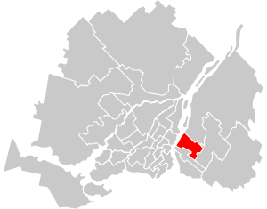
Country:
 Canada
Region:
City:
Latitude and Longitude:
Time Zone:
Postal Code:
IP information under different IP Channel
ip-api
Country
Region
City
ASN
Time Zone
ISP
Blacklist
Proxy
Latitude
Longitude
Postal
Route
IPinfo
Country
Region
City
ASN
Time Zone
ISP
Blacklist
Proxy
Latitude
Longitude
Postal
Route
MaxMind
Country
Region
City
ASN
Time Zone
ISP
Blacklist
Proxy
Latitude
Longitude
Postal
Route
Luminati
Country
CARegion
qc
City
longueuil
ASN
Time Zone
America/Toronto
ISP
OXIO-ASN-01
Latitude
Longitude
Postal
db-ip
Country
Region
City
ASN
Time Zone
ISP
Blacklist
Proxy
Latitude
Longitude
Postal
Route
ipdata
Country
Region
City
ASN
Time Zone
ISP
Blacklist
Proxy
Latitude
Longitude
Postal
Route
Popular places and events near this IP address
Longueuil—Saint-Hubert
Federal electoral district in Quebec, Canada
Distance: Approx. 2971 meters
Latitude and longitude: 45.54166667,-73.44166667
Longueuil—Saint-Hubert (formerly Longueuil—Pierre-Boucher and Longueuil) is a federal electoral district in Quebec, Canada, represented in the House of Commons of Canada from since 2015
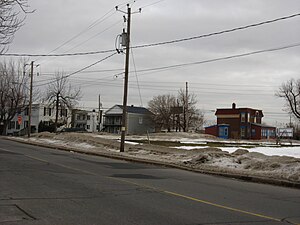
Le Moyne, Quebec
Neighbourhood in Longueuil, Quebec, Canada
Distance: Approx. 2942 meters
Latitude and longitude: 45.50188889,-73.49061111
Le Moyne (also known as Ville Le Moyne, formerly known as LeMoyne) is a neighbourhood in Longueuil, Quebec, part of the borough of Le Vieux-Longueuil, and a former city. Le Moyne makes up 2% of the total area of Le Vieux-Longueuil borough and is the only neighbourhood of the borough that was not part of the pre-2002 city of Longueuil. Residents of Le Moyne are called Le Moynois.

Colisée Jean Béliveau
Arena in Longueuil, Quebec, Canada
Distance: Approx. 2815 meters
Latitude and longitude: 45.54416667,-73.45722222
The Colisée Jean-Béliveau (originally known as Aréna Jacques-Cartier) is a multi-purpose arena built in 1966 in Longueuil, Quebec, and home to the ice hockey team of Le Collège Français de Longueuil, that play in the Quebec Junior AAA Hockey League. The arena was originally named Aréna Jacques-Cartier, but renamed in 1971 in honour of former hockey great, Jean Béliveau to mark his 500th career goal. It has 2,400 seats, and a total capacity of 2,600 with standing room.

Marie-Victorin (electoral district)
Provincial electoral district in Quebec, Canada
Distance: Approx. 1875 meters
Latitude and longitude: 45.52,-73.486
Marie-Victorin is a provincial electoral district in Quebec, Canada that elects members to the National Assembly of Quebec. The district is located in the Vieux-Longueuil Borough of Longueuil. It is bordered to the north by chemin de Chambly, to the east by the city limits, to the south by the Canadian National railway, Boulevard Desaulniers and the city limits, and to the west by the Saint Lawrence River.

Laporte (electoral district)
Provincial electoral district in Quebec, Canada
Distance: Approx. 3062 meters
Latitude and longitude: 45.516,-73.501
Laporte is a provincial electoral district in the Montérégie region of Quebec, Canada that elects members to the National Assembly of Quebec. It was created for the 1973 election from parts of Taillon and Chambly. It was named after former Liberal Minister Pierre Laporte who was kidnapped and killed by militants of the Front de libération du Québec during the October Crisis in 1970.

Laflèche, Quebec
Neighbourhood in Longueuil, Quebec, Canada
Distance: Approx. 2764 meters
Latitude and longitude: 45.496,-73.475
Laflèche (originally known as Mackayville) is a neighbourhood in the Saint-Hubert borough of the city of Longueuil.
Ville Jacques-Cartier
City in the South Shore of Montreal
Distance: Approx. 2298 meters
Latitude and longitude: 45.53333333,-73.48333333
Ville Jacques-Cartier was a city located on the south shore of Montreal, Quebec, Canada. It was named after the founder of New France, Jacques Cartier. Now a defunct municipality, its former territory makes up about a quarter of the current city of Longueuil and 80% of Le Vieux-Longueuil borough.

Longueuil–Saint-Hubert station
Railway station in Quebec, Canada
Distance: Approx. 2420 meters
Latitude and longitude: 45.50805556,-73.43527778
Longueuil–Saint-Hubert station is a commuter rail station operated by Exo in the Saint-Hubert borough of Longueuil, Quebec, Canada. It is served by the Mont-Saint-Hilaire line.
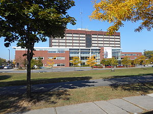
Hôpital Pierre Boucher
Hospital in Longueuil, Quebec, Canada
Distance: Approx. 2145 meters
Latitude and longitude: 45.5382,-73.4584
Pierre Boucher Hospital (French: Hôpital Pierre-Boucher) is a Canadian hospital located on Jacques Cartier Boulevard in Longueuil, Quebec. Inaugurated in 1982, the hospital is the regional health centre for 245,000 people located in the borough of Le Vieux-Longueuil, as well as the cities and towns of Boucherville, Varennes, Verchères, Sainte-Julie, Saint-Amable, Calixa-Lavallée and Contrecœur. The hospital provides general, specialized and ultraspecialized health care, and is also the location of 3,400 births per year.
Chambly County, Quebec
Former county in Quebec, Canada
Distance: Approx. 960 meters
Latitude and longitude: 45.521,-73.45
Chambly County was a county of Quebec that existed between 1855 and the early 1980s. The territory of the county today forms part of the Montérégie administrative region and the Urban agglomeration of Longueuil and the Regional county municipality of la Vallée-du-Richelieu. The county seat was Longueuil.
Collège Français (Longueuil)
Secondary school in Longueuil, Quebec, Canada
Distance: Approx. 2052 meters
Latitude and longitude: 45.508,-73.483
Collège Français is a private French-language secondary school in Longueuil, Quebec, Canada. It was established in 1987. It followed a Collège Français primary school that opened in Longueuil in 1972, and a campus of the Collège Français secondary school in Montreal which opened in 1959.

Longueuil—Charles-LeMoyne
Federal electoral district in Quebec, Canada
Distance: Approx. 2971 meters
Latitude and longitude: 45.54166667,-73.44166667
Longueuil—Charles-LeMoyne is a federal electoral district in Quebec, Canada, that has been represented in the House of Commons of Canada since 2015. It encompasses a portion of Quebec formerly included in the electoral districts of Saint-Bruno—Saint-Hubert and Saint-Lambert. Longueuil—Charles-LeMoyne was created by the 2012 federal electoral boundaries redistribution and was legally defined in the 2013 representation order.
Weather in this IP's area
clear sky
20 Celsius
20 Celsius
17 Celsius
21 Celsius
1017 hPa
77 %
1017 hPa
1014 hPa
10000 meters
06:36:32
18:59:15