Country:
 Canada
Region:
City:
Latitude and Longitude:
Time Zone:
Postal Code:
IP information under different IP Channel
ip-api
Country
Region
City
ASN
Time Zone
ISP
Blacklist
Proxy
Latitude
Longitude
Postal
Route
IPinfo
Country
Region
City
ASN
Time Zone
ISP
Blacklist
Proxy
Latitude
Longitude
Postal
Route
MaxMind
Country
Region
City
ASN
Time Zone
ISP
Blacklist
Proxy
Latitude
Longitude
Postal
Route
Luminati
Country
CARegion
qc
City
montreal
ASN
Time Zone
America/Toronto
ISP
OXIO-ASN-01
Latitude
Longitude
Postal
db-ip
Country
Region
City
ASN
Time Zone
ISP
Blacklist
Proxy
Latitude
Longitude
Postal
Route
ipdata
Country
Region
City
ASN
Time Zone
ISP
Blacklist
Proxy
Latitude
Longitude
Postal
Route
Popular places and events near this IP address

Laurier—Sainte-Marie
Federal electoral district in Quebec, Canada
Distance: Approx. 1306 meters
Latitude and longitude: 45.527,-73.565
Laurier—Sainte-Marie is a federal electoral district in Downtown Montreal, Quebec, Canada, that has been represented in the House of Commons of Canada since 1988. Its population in 2016 was 111,835.

Laurier station (Montreal Metro)
Montreal Metro station
Distance: Approx. 1331 meters
Latitude and longitude: 45.52722222,-73.58666667
Laurier station is a Montreal Metro station in the borough of Le Plateau-Mont-Royal in Montreal, Quebec, Canada. It is operated by the Société de transport de Montréal (STM) and serves the Orange Line. It is located just to the east of the Mile End neighbourhood.
CPR Angus Shops
Distance: Approx. 1089 meters
Latitude and longitude: 45.54333333,-73.56583333
The CPR Angus Shops in Montreal were a railcar manufacturing, repairing and selling facility of the Canadian Pacific Railway. Production mainly consisted of passenger cars, freight cars and locomotives. Built in 1904 and named for founder, Richard B. Angus, the Angus Shops were decommissioned in 1992.

Mercier (provincial electoral district)
Provincial electoral district in Quebec, Canada
Distance: Approx. 982 meters
Latitude and longitude: 45.52777778,-73.57916667
Mercier is a provincial electoral district in the Montreal region of Quebec, Canada that elects members to the National Assembly of Quebec. It consists of part of the Le Plateau-Mont-Royal borough of the city of Montreal. It was created for the 1966 election from parts of Montréal-Mercier and Montréal–Saint-Louis electoral districts.

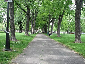
La Fontaine Park
Urban park in Montreal, Canada
Distance: Approx. 1173 meters
Latitude and longitude: 45.5267,-73.5689
La Fontaine Park (French: Parc La Fontaine) is a 34 ha (84 acres) urban park located in the borough of Le Plateau-Mont-Royal in Montreal, Quebec, Canada. Named in honour of Louis-Hippolyte Lafontaine, The park's features include two linked ponds with a fountain and waterfalls, the Théâtre de Verdure open-air venue, the Calixa-Lavallée cultural centre, a monument to Adam Dollard des Ormeaux, playing fields and tennis courts. Its ponds are a popular attraction during Montreal's hot summers, with outdoor ice skating in winter.
Les Brasseurs RJ
Distance: Approx. 1268 meters
Latitude and longitude: 45.5338,-73.5913
Les Brasseurs RJ is a brewery located in Montreal, Quebec, Canada. The company was founded in 1998 by Roger Jaar from the merger of three microbreweries: Les Brasseurs GMT, La Brasserie Le Cheval Blanc and Les Brasseurs de l'Anse. Current annual production capacity is over 125,000 hL; they claim to be the largest microbrewery in Quebec.
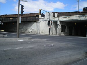
Tunnel de la mort
Distance: Approx. 564 meters
Latitude and longitude: 45.54111111,-73.57361111
"Tunnel de la mort" (Tunnel of Death) is the informal name given, in Montreal, to the notoriously dangerous intersection of Rue d'Iberville and Boulevard Saint-Joseph, at the border of the Rosemont–La Petite-Patrie and Plateau-Mont-Royal boroughs. The intersection owes this name to the dangerously poor visibility caused by the three railway overpasses immediately to the north, east, and west of it, and by concrete retaining walls on all four corners. More than 250 serious accidents were reported at that intersection between 1992 and 2002.

Jean-Deslauriers Theatre
Distance: Approx. 1131 meters
Latitude and longitude: 45.526964,-73.569342
The Jean-Deslauriers Theatre (French: Salle Jean-Deslauriers) is a Canadian concert auditorium located in Montreal, Quebec. Built by the Catholic School Commission of Montreal in the early 1930s, the hall was originally named Plateau Hall (French: Auditorium le Plateau). It was renamed in 1975 in honour of conductor Jean Deslauriers.
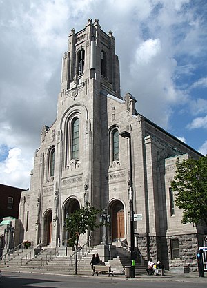
Saint-Esprit-de-Rosemont Church
Church in Quebec, Canada
Distance: Approx. 1289 meters
Latitude and longitude: 45.54777778,-73.57527778
The Church of the Holy Spirit of Rosemont (French: Église St. Esprit de Rosemont) (formerly the Church of Ste. Philomène), is a Roman Catholic church in the Rosemont–La Petite-Patrie borough of Montreal, Quebec, Canada.

La Banquise
Restaurant in Quebec, Canada
Distance: Approx. 1212 meters
Latitude and longitude: 45.525318,-73.574951
La Banquise is a restaurant in Montreal, Quebec, Canada which specializes in the dish of poutine. It serves over thirty different kinds of poutine and is open 24 hours. Its address is 994 Rue Rachel East in the borough of Le Plateau-Mont-Royal.
CHRF
Former radio station in Montreal
Distance: Approx. 1264 meters
Latitude and longitude: 45.5405,-73.5904
CHRF (980 kHz) was a French language commercial AM radio station in Montreal, Quebec, Canada. Owned by Evanov Radio Group, the station broadcast an adult standards radio format, along with some multicultural programming. CHRF's studios were located on Papineau Avenue in the Rosemont–La Petite-Patrie borough of Montreal, while its transmitter is located near Mercier.
Sir Wilfrid Laurier Park
Urban park in Montreal, Canada
Distance: Approx. 1009 meters
Latitude and longitude: 45.5312,-73.5862
Sir Wilfrid Laurier Park (French: Parc Sir-Wilfrid-Laurier) is an urban park in the Le Plateau-Mont-Royal borough of Montreal, Quebec, Canada. It is bordered by Laurier Avenue East to the south, De Brébeuf Street to the east, Saint Grégoire Street to the north and De Mentana Street to the west. It is crossed by a north–south bicycle path.
Weather in this IP's area
clear sky
20 Celsius
20 Celsius
17 Celsius
21 Celsius
1017 hPa
79 %
1017 hPa
1012 hPa
10000 meters
06:36:59
18:59:42