Country:
 Canada
Region:
City:
Latitude and Longitude:
Time Zone:
Postal Code:
IP information under different IP Channel
ip-api
Country
Region
City
ASN
Time Zone
ISP
Blacklist
Proxy
Latitude
Longitude
Postal
Route
IPinfo
Country
Region
City
ASN
Time Zone
ISP
Blacklist
Proxy
Latitude
Longitude
Postal
Route
MaxMind
Country
Region
City
ASN
Time Zone
ISP
Blacklist
Proxy
Latitude
Longitude
Postal
Route
Luminati
Country
CARegion
qc
City
montreal
ASN
Time Zone
America/Toronto
ISP
OXIO-ASN-01
Latitude
Longitude
Postal
db-ip
Country
Region
City
ASN
Time Zone
ISP
Blacklist
Proxy
Latitude
Longitude
Postal
Route
ipdata
Country
Region
City
ASN
Time Zone
ISP
Blacklist
Proxy
Latitude
Longitude
Postal
Route
Popular places and events near this IP address

Laurier—Sainte-Marie
Federal electoral district in Quebec, Canada
Distance: Approx. 933 meters
Latitude and longitude: 45.527,-73.565
Laurier—Sainte-Marie is a federal electoral district in Downtown Montreal, Quebec, Canada, that has been represented in the House of Commons of Canada since 1988. Its population in 2016 was 111,835.

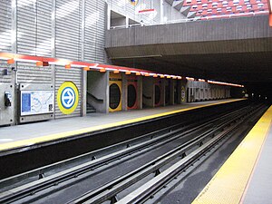
Papineau station
Montreal Metro station
Distance: Approx. 1087 meters
Latitude and longitude: 45.52361111,-73.55222222
Papineau station is a Montreal Metro station in the borough of Ville-Marie in Montreal, Quebec, Canada. It is operated by the Société de transport de Montréal (STM) and serves the Green Line. It is one of two Metro stations that service Montreal's Gay Village, part of the Centre-Sud district.

Frontenac station
Montreal Metro station
Distance: Approx. 358 meters
Latitude and longitude: 45.53333333,-73.55194444
Frontenac station is a Montreal Metro station in the borough of Ville-Marie in Montreal, Quebec, Canada. It is operated by the Société de transport de Montréal (STM) and serves the Green Line. It is located at 2570 Ontario Street East in the Sainte-Marie neighbourhood, part of the Centre-Sud.
Préfontaine station
Montreal Metro station
Distance: Approx. 989 meters
Latitude and longitude: 45.54166667,-73.55444444
Préfontaine station is a Montreal Metro station in the borough of Mercier–Hochelaga-Maisonneuve in Montreal, Quebec, Canada. It is operated by the Société de transport de Montréal (STM) and serves the Green Line. It is in the district of Hochelaga-Maisonneuve.

Delorimier Stadium
Former Canadian baseball venue
Distance: Approx. 514 meters
Latitude and longitude: 45.52833333,-73.5575
Delorimier Stadium (French pronunciation: [dəlɔʁimje]; also known as Montreal Stadium, Hector Racine Stadium and Delorimier Downs) was a 20,000-seat sports stadium in Montreal, Quebec, Canada. It was located at 2101 Ontario Street East, at the corner of De Lorimier Avenue in the present-day Montreal borough of Ville-Marie. The stadium was home to the Montreal Royals of the International League, as the top farm club of the Brooklyn Dodgers from 1928 to 1960.
Sainte-Marie (provincial electoral district)
Provincial electoral district in Quebec, Canada
Distance: Approx. 288 meters
Latitude and longitude: 45.531,-73.554
Sainte-Marie was a provincial electoral district in the Montreal region of Quebec, Canada. It corresponded to the Sainte-Marie neighbourhood and eastern Ville-Marie in Montreal. It was created for the 1966 election from parts of Montréal–Sainte-Marie, Montréal–Saint-Jacques and Maisonneuve electoral districts.

La Fontaine Park
Urban park in Montreal, Canada
Distance: Approx. 1188 meters
Latitude and longitude: 45.5267,-73.5689
La Fontaine Park (French: Parc La Fontaine) is a 34 ha (84 acres) urban park located in the borough of Le Plateau-Mont-Royal in Montreal, Quebec, Canada. Named in honour of Louis-Hippolyte Lafontaine, The park's features include two linked ponds with a fountain and waterfalls, the Théâtre de Verdure open-air venue, the Calixa-Lavallée cultural centre, a monument to Adam Dollard des Ormeaux, playing fields and tennis courts. Its ponds are a popular attraction during Montreal's hot summers, with outdoor ice skating in winter.

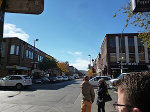
Centre-Sud
Neighbourhood in Montreal, Quebec, Canada
Distance: Approx. 1100 meters
Latitude and longitude: 45.523565,-73.55187
The Centre-Sud is a neighbourhood located in the easternmost edge of the Ville-Marie borough of the city of Montreal. Home to Montreal's Gay Village and to the Sainte-Marie area, the Centre-Sud has long been seen as one of the city's most complex and troubled neighbourhoods. Having held a notorious reputation for poverty and prostitution for decades, particularly on Rue Ontario and Rue Dufresne, gentrification has changed the neighbourhood considerably in recent years.
Papineau Avenue
Thoroughfare in Montreal, Canada
Distance: Approx. 1142 meters
Latitude and longitude: 45.522922,-73.553074
Papineau Avenue (French: avenue Papineau) is the longest north–south street in Montreal, Quebec, Canada. The part of the street between Henri Bourassa Boulevard and Quebec Autoroute 40 is the Montreal portion of Quebec Autoroute 19, commonly referred to as Autoroute Papineau. North of Henri Bourassa Boulevard, it becomes a true autoroute before crossing the Rivière des Prairies on the Papineau-Leblanc Bridge.

Jean-Deslauriers Theatre
Distance: Approx. 1200 meters
Latitude and longitude: 45.526964,-73.569342
The Jean-Deslauriers Theatre (French: Salle Jean-Deslauriers) is a Canadian concert auditorium located in Montreal, Quebec. Built by the Catholic School Commission of Montreal in the early 1930s, the hall was originally named Plateau Hall (French: Auditorium le Plateau). It was renamed in 1975 in honour of conductor Jean Deslauriers.
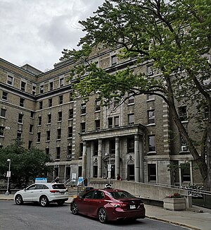
Hôpital Notre-Dame
Hospital in Montreal, Quebec
Distance: Approx. 965 meters
Latitude and longitude: 45.526,-73.564
Hôpital Notre-Dame (English: Notre Dame Hospital) is a hospital in Montreal, Quebec, Canada. It is located on Sherbrooke Street East in the borough of Ville-Marie, across from La Fontaine Park. It was established in 1880, and has been at its present site since 1924.

William Scully Ltd.
Distance: Approx. 936 meters
Latitude and longitude: 45.53995,-73.54997
William Scully Ltd. is a Canadian uniform accoutrements manufacturer based in Montreal, QC, Canada, founded in 1877 by William Scully, a British manufacturers’ Canadian Representative, in Toronto. He was the first Canadian representative of London's Welsh Margetson and Sons.
Weather in this IP's area
clear sky
20 Celsius
20 Celsius
17 Celsius
21 Celsius
1017 hPa
79 %
1017 hPa
1014 hPa
10000 meters
06:36:54
18:59:38