Country:
Region:
City:
Latitude and Longitude:
Time Zone:
Postal Code:
IP information under different IP Channel
ip-api
Country
Region
City
ASN
Time Zone
ISP
Blacklist
Proxy
Latitude
Longitude
Postal
Route
IPinfo
Country
Region
City
ASN
Time Zone
ISP
Blacklist
Proxy
Latitude
Longitude
Postal
Route
MaxMind
Country
Region
City
ASN
Time Zone
ISP
Blacklist
Proxy
Latitude
Longitude
Postal
Route
Luminati
Country
Region
qc
City
quebec
ASN
Time Zone
America/Toronto
ISP
OXIO-ASN-01
Latitude
Longitude
Postal
db-ip
Country
Region
City
ASN
Time Zone
ISP
Blacklist
Proxy
Latitude
Longitude
Postal
Route
ipdata
Country
Region
City
ASN
Time Zone
ISP
Blacklist
Proxy
Latitude
Longitude
Postal
Route
Popular places and events near this IP address

Québec (electoral district)
Federal electoral district in Quebec, Canada
Distance: Approx. 309 meters
Latitude and longitude: 46.81666667,-71.26666667
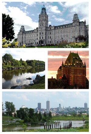
Québec (formerly known as Langelier) is a federal electoral district that has been represented in the House of Commons of Canada since 1968. It is located in Quebec City in the province of Quebec, Canada. Since its creation, the riding has been a provincial bellwether in federal elections.
Vanier, Quebec City
Distance: Approx. 719 meters
Latitude and longitude: 46.82036111,-71.26652778
Vanier is a former city in central Quebec, Canada. It was amalgamated into Quebec City in 2002. It is located within the Borough of Les Rivières.

Pavillon Guy-Lafleur
Distance: Approx. 2047 meters
Latitude and longitude: 46.8273,-71.248
The Pavillon Guy-Lafleur, formerly Pavillon de la Jeunesse, (1970-2024) is an indoor arena, in Quebec City, Quebec on the grounds of ExpoCité. It opened in 1931 as an amphitheatre to replace the Victoria Park Arena destroyed in 1943, it was referred to as Pavillon de l'agriculture (1931 to 1970) for use for agricultural displays for the provincial exhibition or Expo Quebec. Since the 1980s it has been used as a sports venue and has a capacity of 5,000 spectators.
Fleur de Lys centre commercial
Shopping mall
Distance: Approx. 1449 meters
Latitude and longitude: 46.8224,-71.252
Fleur de Lys centre commercial (formerly and still commonly called Place Fleur de Lys) is a shopping mall located in the Vanier borough of Quebec City, Quebec, Canada built in 1963. It is located across from L'Institut de réadaptation en déficience physique de Québec and close to the Videotron Centre. It is anchored by Walmart and Maxi.

La Cité-Limoilou
Borough of Quebec City in Canada
Distance: Approx. 2396 meters
Latitude and longitude: 46.8219,-71.2372
La Cité-Limoilou (French pronunciation: [la site limwalu]) is the central borough of Quebec City, the oldest (in terms of architecture), and the most populous, comprising 19.73% of the city's total population. As an administrative division, it is very new, having only been formed on November 1, 2009, from the former boroughs of La Cité and Limoilou.
Jeffrey Hale - St Brigid's Hospital
Hospital in Quebec, Canada
Distance: Approx. 2166 meters
Latitude and longitude: 46.7967,-71.2531
Jeffery Hale - Saint Brigid's is a publicly funded health establishment located in Quebec City, Quebec, Canada. It provides a range of primary health care services to the population of Quebec's Capitale-Nationale (Greater Quebec City) region.

Videotron Centre
Indoor arena in Quebec City
Distance: Approx. 2189 meters
Latitude and longitude: 46.829,-71.248
Vidéotron Centre (French: Centre Vidéotron) is an indoor arena in Quebec City, Quebec, Canada. The 18,259-seat arena replaced Colisée Pepsi as Quebec City's primary venue for indoor events. The arena is primarily used for ice hockey, serving as the home arena of the Quebec Remparts of the QMJHL and has been prospected as a venue for a new or re-located National Hockey League team in Quebec City, and as part of a Winter Olympic Games bid.

ExpoCité
Distance: Approx. 2156 meters
Latitude and longitude: 46.828,-71.247
ExpoCité (formerly Parc de l'Exposition) is a multi-site entertainment complex located in the borough of La Cité-Limoilou, in downtown Quebec City. This is also the name of the corporation authorized by the City of Quebec to administer the site. ExpoCité was best known for Expo Québec an annual 12-day exhibition held in August but folded in 2016.
Saint-Sauveur (electoral district)
Former provincial electoral district in the Capitale-Nationale region of Quebec, Canada
Distance: Approx. 1049 meters
Latitude and longitude: 46.818,-71.254
Saint-Sauveur was a former provincial electoral district in the Capitale-Nationale region of Quebec, Canada. It was created for the 1890 election from part of Québec-Est electoral district. Its final election was in 1970.
Quebec County (Province of Canada electoral district)
Electoral district in former Province of Canada
Distance: Approx. 654 meters
Latitude and longitude: 46.8165,-71.2741
Quebec County (French: Comté de Québec) was an electoral district of the Legislative Assembly of the Parliament of the Province of Canada, in Canada East, surrounding Quebec City. It was created in 1841 and was based on the previous electoral district of the same name for the Legislative Assembly of Lower Canada. Quebec County was represented by one member in the Legislative Assembly.

Lairet River
Tributary of Saint-Charles River in Québec, Canada
Distance: Approx. 2372 meters
Latitude and longitude: 46.82388889,-71.23888889
The Lairet River is a tributary of the Saint-Charles River, crossing Quebec City, Quebec, Canada. Over two kilometers long, it took its source in the vicinity of Charlesbourg and flowed in meanders in Limoilou. It has been completely channeled since the 1960s, except for a segment refitted in 2008.
Saint-Sauveur, Quebec City
Distance: Approx. 1748 meters
Latitude and longitude: 46.80777778,-71.24527778
Saint-Sauveur (French pronunciation: [sɛ̃ sovœʁ] ) is one of the 35 neighbourhoods of Quebec City, and one of the six that are situated within the borough of La Cité–Limoilou. It is one of the neighbourhoods which form the Lower Town of Quebec City. The neighbourhood is named after Jean Le Sueur.
Weather in this IP's area
few clouds
18 Celsius
18 Celsius
16 Celsius
19 Celsius
1017 hPa
84 %
1017 hPa
1016 hPa
10000 meters
20 %
06:27:19
18:50:54
