Country:
Region:
City:
Latitude and Longitude:
Time Zone:
Postal Code:
IP information under different IP Channel
ip-api
Country
Region
City
ASN
Time Zone
ISP
Blacklist
Proxy
Latitude
Longitude
Postal
Route
Luminati
Country
Region
qc
City
quebec
ASN
Time Zone
America/Toronto
ISP
OXIO-ASN-01
Latitude
Longitude
Postal
IPinfo
Country
Region
City
ASN
Time Zone
ISP
Blacklist
Proxy
Latitude
Longitude
Postal
Route
db-ip
Country
Region
City
ASN
Time Zone
ISP
Blacklist
Proxy
Latitude
Longitude
Postal
Route
ipdata
Country
Region
City
ASN
Time Zone
ISP
Blacklist
Proxy
Latitude
Longitude
Postal
Route
Popular places and events near this IP address

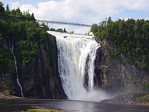
Montmorency Falls
Waterfall on the Montmorency River in Québec, Canada
Distance: Approx. 6592 meters
Latitude and longitude: 46.89083333,-71.1475
The Montmorency Falls (French: Chute Montmorency) is a large waterfall on the Montmorency River in Quebec, Canada.

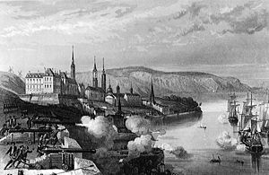
Battle of Quebec (1690)
October 1690 battle near Quebec City, Canada
Distance: Approx. 5819 meters
Latitude and longitude: 46.96666667,-71.26666667
The Battle of Québec was fought in October 1690 between the colonies of New France and Massachusetts Bay, then ruled by the kingdoms of France and England, respectively. It was the first time Québec's defences were tested. Following the capture of Port Royal in Acadia, during King William's War, the New Englanders hoped to seize Québec itself, the capital of New France.
Boischatel
Municipality in Quebec, Canada
Distance: Approx. 5835 meters
Latitude and longitude: 46.9,-71.15
Boischatel is a municipality in the Capitale-Nationale region of Quebec, Canada. The town was originally called Saint-Jean-de-Boischatel. The town itself is located along the Montmorency River.

Royal Quebec Golf Club
Golf club near Quebec City
Distance: Approx. 5727 meters
Latitude and longitude: 46.903,-71.149
The Royal Quebec Golf Club (French: Club de Golf Royal Québec) is a golf club founded in 1874 in Boischatel by members of the local business community, mainly Scots-Quebecer bankers and businessmen. Located approximately 12 miles (18 km) east of Quebec City, near Montmorency Falls, it has been a semi-private club since 1925. One of the oldest golf clubs in North America, the current 36-hole facility is situated on a 186-hectare piece of land with pine trees.
Montmorency (provincial electoral district)
Provincial electoral district in Quebec, Canada
Distance: Approx. 6746 meters
Latitude and longitude: 46.96666667,-71.28333333
Montmorency is a provincial electoral district in the Capitale-Nationale region of Quebec, Canada. It comprises part of the Beauport borough of Quebec City and the municipality of Sainte-Brigitte-de-Laval. It was created for the 1867 election (and an electoral district of that name existed earlier in the Legislative Assembly of the Province of Canada and the Legislative Assembly of Lower Canada).
Montmorency River
River in Quebec, Canada
Distance: Approx. 7255 meters
Latitude and longitude: 46.885,-71.14333333
The Montmorency River is a tributary of North-East bank of St. Lawrence river, flowing in the administrative region of Capitale-Nationale, in the province of Quebec, Canada. The course of the river successively crosses the regional county municipality of: MRC La Côte-de-Beaupré Regional County Municipality: Lac-Jacques-Cartier, Château-Richer, L'Ange-Gardien, Boischatel; MRC La Jacques-Cartier Regional County Municipality: Sainte-Brigitte-de-Laval Agglomération de Québec.
Rivière aux Pins (Montmorency River tributary)
River in Quebec, Canada
Distance: Approx. 6467 meters
Latitude and longitude: 46.98528,-71.19722
The Rivière aux Pins (English: Pine River) is a tributary of the Montmorency River, which is a tributary of the north shore of the St. Lawrence River, flowing in Sainte-Brigitte-de-Laval, in the La Jacques-Cartier Regional County Municipality, in the administrative region of Capitale-Nationale, in the province of Quebec, in Canada. The lower part of this valley is served by avenue Sainte-Brigitte, by rue des Monardes and by rue du Ruisseau.

Rivière des Roches (rivière du Berger)
Tributary of Saint-Charles River in Québec, Canada
Distance: Approx. 6736 meters
Latitude and longitude: 46.89555556,-71.28888889
The Rivière des Roches is a tributary of the rivière du Berger flowing in the sectors Beauport and Charlesbourg in Quebec City, in the region of Capitale-Nationale, in the province of Quebec, in Canada. Taking its source in the Lac des Roches, it has a length of approximately 5.3 km. The valley of the Roches river does not have a road except its upper part which is served east of Lac des Roches by Arthur-Drolet road and northeast by Lac-des-Roches road.
Lac des Roches
Lake in Capitale-Nationale, Quebec, Canada
Distance: Approx. 2920 meters
Latitude and longitude: 46.92111111,-71.25138889
The Lac des Roches (English: lake of rocks) is a freshwater body of the city of Quebec, in the region of the Capitale-Nationale, in the province of Quebec, in Canada. It is the main reserve of drinking water in the arrondissement of Charlesbourg. Lac des Roches is mainly fed by five forest streams from the surrounding mountains.

Beauport Lake
Lake in Capitale-Nationale, Quebec, Canada
Distance: Approx. 5421 meters
Latitude and longitude: 46.95388889,-71.27527778
The lac Beauport is a body of water located north of Quebec, surrounded by the municipality of Lac-Beauport, in the La Jacques-Cartier Regional County Municipality, in the region of Capitale-Nationale, in the province of Quebec, in Canada. It covers an area of 0.8 square kilometres (0.31 sq mi), at a maximum depth of 13 meters. The lake outlet flows into the Jaune River.
Rivière du Lac
River in Quebec, Canada
Distance: Approx. 1666 meters
Latitude and longitude: 46.93444444,-71.19444444
The rivière du Lac (English: River of the lake) is a tributary of the west bank of the Montmorency River. This watercourse flows on the north shore of the St. Lawrence River, in the city of Quebec, in the administrative region of Capitale-Nationale, in the province of Quebec, in Canada.
Ferrée River (Montmorency River tributary)
River in La Côte-de-Beaupré Regional County Municipality, Canada
Distance: Approx. 4559 meters
Latitude and longitude: 46.90139,-71.16944
The Ferrée river is a tributary on the east bank of the Montmorency River. It flows in the municipalities of L'Ange-Gardien and Boischatel, in the La Côte-de-Beaupré Regional County Municipality, in the administrative region of Capitale-Nationale, in the province of Quebec, in Canada. The upper part of this valley is served by Chemin des Sucreries, by Chemin du Nord-de-la-Ligne Hydro and by a few forest roads.
Weather in this IP's area
light rain
8 Celsius
5 Celsius
6 Celsius
9 Celsius
1001 hPa
74 %
1001 hPa
974 hPa
10000 meters
4.02 m/s
9.83 m/s
279 degree
98 %
06:38:27
16:18:54

