Country:
Region:
City:
Latitude and Longitude:
Time Zone:
Postal Code:
IP information under different IP Channel
ip-api
Country
Region
City
ASN
Time Zone
ISP
Blacklist
Proxy
Latitude
Longitude
Postal
Route
Luminati
Country
Region
qc
City
montreal
ASN
Time Zone
America/Toronto
ISP
OXIO-ASN-01
Latitude
Longitude
Postal
IPinfo
Country
Region
City
ASN
Time Zone
ISP
Blacklist
Proxy
Latitude
Longitude
Postal
Route
db-ip
Country
Region
City
ASN
Time Zone
ISP
Blacklist
Proxy
Latitude
Longitude
Postal
Route
ipdata
Country
Region
City
ASN
Time Zone
ISP
Blacklist
Proxy
Latitude
Longitude
Postal
Route
Popular places and events near this IP address

Sainte-Foy, Quebec City
Districts in Quebec, Canada
Distance: Approx. 3732 meters
Latitude and longitude: 46.76944444,-71.30833333
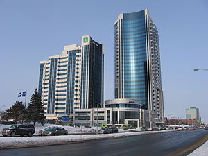
Sainte-Foy is a former city in central Quebec, Canada alongside the Saint Lawrence River. It was amalgamated into Quebec City at the start of 2002. Most of the formerly independent municipality of Sainte-Foy is located in the borough (French: arrondissement) of Sainte-Foy–Sillery–Cap-Rouge — initially as one of the two constituent districts of the former borough of Sainte-Foy–Sillery.

Cap-Rouge, Quebec City
Neighbourhood in Quebec City, Canada
Distance: Approx. 145 meters
Latitude and longitude: 46.75,-71.35
Cap-Rouge is a former city in central Quebec, Canada, since 2002 within the borough Sainte-Foy–Sillery–Cap-Rouge in Quebec City. The site of the first attempted permanent French settlement in North America, Charlesbourg-Royal, is located at the confluence of the Rivière du Cap Rouge and the Saint Lawrence River. Its population was 13,153 as of the Canada 2011 Census.
Québec/Lac Saint-Augustin Water Airport
Airport in Quebec City
Distance: Approx. 3518 meters
Latitude and longitude: 46.75138889,-71.39416667
Québec/Lac Saint-Augustin Water Airport (TC LID: CSN8) is located 6 nautical miles (11 km; 6.9 mi) southwest of Quebec City, Quebec, Canada.
Charlesbourg-Royal
Historic site in Quebec, Canada
Distance: Approx. 608 meters
Latitude and longitude: 46.74761111,-71.34085556
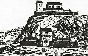
Fort Charlesbourg Royal (1541—1543) is a National Historic Site in the Cap-Rouge neighbourhood of Quebec City, Quebec, Canada. Established by Jacques Cartier in 1541, it was France's first attempt at a colony in North America, and was abandoned two years later. In 1608, France would establish a successful colony, the Habitation de Québec, 15 kilometers east of the Cap-Rouge fort.

Jean-Talon
Provincial electoral district in Quebec, Canada
Distance: Approx. 3561 meters
Latitude and longitude: 46.76666667,-71.30833333
Jean-Talon is a provincial electoral riding in the Capitale-Nationale region of Quebec, Canada. It consists of part of the Sainte-Foy–Sillery–Cap-Rouge borough of Quebec City. It was named after former French colonial administrator of New France, Jean Talon.

Sainte-Foy station
Railway station in Quebec, Canada
Distance: Approx. 3875 meters
Latitude and longitude: 46.7543,-71.2977
Sainte-Foy station is a Via Rail station in Quebec City, Quebec, Canada. it is located on Chemin de la Gare in the former city of Sainte-Foy. It is staffed and is wheelchair-accessible.

Sainte-Foy–Sillery–Cap-Rouge
Borough in Quebec, Canada
Distance: Approx. 3561 meters
Latitude and longitude: 46.76666667,-71.30833333
Sainte-Foy–Sillery–Cap-Rouge is a borough of Quebec City, Quebec, Canada. The borough was created on November 1, 2009, from the former borough of Sainte-Foy–Sillery and part of the former borough of Laurentien. Those boroughs in turn had been created on January 1, 2002; on that date, the former city of Cap-Rouge, a small part of the former city of Sainte-Foy, and other territory went into Laurentien, while the former city of Sillery and the rest of Sainte-Foy formed Sainte-Foy–Sillery.
CFOI-FM
Christian radio station in Quebec City, Quebec
Distance: Approx. 3995 meters
Latitude and longitude: 46.77083333,-71.30555556
CFOI-FM (104.1 MHz) is a Canadian FM radio station that broadcasts a Christian radio format in Quebec City, Quebec. Owned by Association d'Églises baptistes reformées du Québec (Baptist Reformed Church Association of Quebec), the station received CRTC approval on January 24, 2007. On November 18, 2009, CFOI-FM applied to change its frequency from 96.9 to 104.1 MHz, which received CRTC approval on February 19, 2010.
Cap-Rouge trestle
Bridge in Quebec, Canada
Distance: Approx. 126 meters
Latitude and longitude: 46.7488,-71.3485
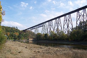
The Cap-Rouge trestle (French: Tracel de Cap-Rouge) is a railway trestle bridge inaugurated in 1908 and still in use in the community of Cap-Rouge, part of the borough of Sainte-Foy–Sillery–Cap-Rouge in Quebec City, Quebec, Canada. It was commissioned in 1906 as a section of the National Transcontinental Railway to span the Rivière du Cap Rouge valley and connect the eastbound railway with the newly built and nearby Quebec Bridge. It was built as a steel structure by the Dominion Bridge Company at a total cost of 800 000 Canadian dollars.

Rivière du Cap Rouge
River in Quebec, Canada
Distance: Approx. 411 meters
Latitude and longitude: 46.7486111,-71.3430556
The Cap-Rouge river (French: Rivière du Cap Rouge) is a river flowing on the north shore of the Saint-Laurent river at the height of the Sainte-Foy–Sillery–Cap-Rouge borough of Quebec City and in the city of Saint-Augustin-de-Desmaures, both cities in the administrative region of Capitale-Nationale, in the province of Quebec, Canada. The catchment area of the Cap Rouge river extends into: the regional county municipality (MRC) of La Jacques-Cartier Regional County Municipality: in the Sainte-Catherine-de-la-Jacques-Cartier; the agglomeration of Quebec: L'Ancienne-Lorette, Saint-Augustin-de-Desmaures and the city of Quebec. The Cap Rouge river valley is mainly served by the route 367 (route de Fossambault) which is perpendicular to the Saint-Laurent river, the "chemin du rang des Mines" (on the south shore from the top), route 138 (boulevard Wilfrid-Hamel), boulevard Auclair, avenue Le Gendre, boulevard de la Chaudière, rue Provencher and rue Saint-Félix.

Promontory of Quebec
Part of Quebec City
Distance: Approx. 4291 meters
Latitude and longitude: 46.772,-71.302
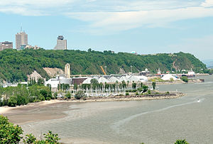
In Quebec City, the term promontory of Quebec refers to the area on which is built the upper part of the borough of La Cité-Limoilou, including Old Quebec (where the promontory is referred to as Cap Diamant). This area covers the eastern half of a larger plateau attested in French as colline or even plate-forme de Québec (Quebec hill). The western portion of this plateau is occupied by upper Sainte-Foy–Sillery–Cap-Rouge (ie.
Champigny, Quebec City
Place in Quebec, Canada
Distance: Approx. 3725 meters
Latitude and longitude: 46.78333333,-71.35
Champigny is an administrative sector and neighbourhood of Quebec City. It is also the name of a sub-sub-fief on the île d'Orléans in the era of New France that may have give its name to the neighbourhood. Also located here are Champigny Park, Champigny Street East and Champigny Street West.
Weather in this IP's area
light intensity shower rain
9 Celsius
5 Celsius
7 Celsius
10 Celsius
1002 hPa
73 %
1002 hPa
1001 hPa
3219 meters
9.77 m/s
14.4 m/s
280 degree
75 %
06:38:31
16:19:54

