Country:
 Canada
Region:
City:
Latitude and Longitude:
Time Zone:
Postal Code:
IP information under different IP Channel
ip-api
Country
Region
City
ASN
Time Zone
ISP
Blacklist
Proxy
Latitude
Longitude
Postal
Route
IPinfo
Country
Region
City
ASN
Time Zone
ISP
Blacklist
Proxy
Latitude
Longitude
Postal
Route
MaxMind
Country
Region
City
ASN
Time Zone
ISP
Blacklist
Proxy
Latitude
Longitude
Postal
Route
Luminati
Country
CARegion
qc
City
ascotcorner
ASN
Time Zone
America/Toronto
ISP
OXIO-ASN-01
Latitude
Longitude
Postal
db-ip
Country
Region
City
ASN
Time Zone
ISP
Blacklist
Proxy
Latitude
Longitude
Postal
Route
ipdata
Country
Region
City
ASN
Time Zone
ISP
Blacklist
Proxy
Latitude
Longitude
Postal
Route
Popular places and events near this IP address
Eastern Townships
Region in south-eastern Quebec, Canada
Distance: Approx. 8249 meters
Latitude and longitude: 45.4814,-71.6678
The Eastern Townships (French: Cantons de l'Est) is a historical administrative region in southeastern Quebec, Canada. It lies between the St. Lawrence Lowlands and the American border, and extends from Granby in the southwest to Drummondville in the northeast.

Estrie
Administrative region in Quebec, Canada
Distance: Approx. 8248 meters
Latitude and longitude: 45.48155556,-71.66791667
Estrie (French pronunciation: [ɛstʁi]) is an administrative region of Quebec that comprises the Eastern Townships. Estrie, a French neologism, was coined as a derivative of est, "east". Originally settled by anglophones, today it is about 90 per cent francophone.

Fleurimont, Quebec
Borough in Quebec, Canada
Distance: Approx. 7610 meters
Latitude and longitude: 45.40594444,-71.83875
Fleurimont is an arrondissement, or borough, of the city of Sherbrooke, Quebec, Canada on the Saint-François River. The borough comprises the former city of Fleurimont and the eastern portion of pre-amalgamation Sherbrooke. As a separate city, Fleurimont had a population of 16,521 in the Canada 2001 Census.
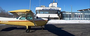
Sherbrooke Airport
Airport in Cookshire-Eaton, Quebec
Distance: Approx. 5652 meters
Latitude and longitude: 45.43861111,-71.69138889
Sherbrooke Airport (IATA: YSC, ICAO: CYSC) is a registered aerodrome located 9 nautical miles (17 km; 10 mi) east northeast of Sherbrooke, in the municipality of Cookshire-Eaton, Quebec, Canada. The airport is classified as an airport of entry by Nav Canada and is staffed by the Canada Border Services Agency (CBSA). CBSA officers at this airport can handle aircraft with up to 30 passengers.
CJMQ-FM
Radio station in Sherbrooke, Quebec
Distance: Approx. 7873 meters
Latitude and longitude: 45.39666667,-71.83111111
CJMQ-FM is a Canadian radio station. Based in Sherbrooke, Quebec, where it has studios in both downtown Sherbrooke and the borough of Lennoxville, the station broadcasts a community radio format targeted to Anglo-Quebecers in Sherbrooke and the Eastern Townships. The station broadcasts at a frequency of 88.9 FM in Sherbrooke, on the cable FM services of Vidéotron (103.9 FM) and Cogeco (104.7 FM), and on the Internet.

East Angus, Quebec
City in Quebec, Canada
Distance: Approx. 8425 meters
Latitude and longitude: 45.48333333,-71.66666667
East Angus (French pronunciation: [istɛ̃ɡys]) is a city in Le Haut-Saint-François Regional County Municipality, in Quebec, Canada. The city had a population of 3,741 as of the Canada 2011 Census.

Ascot Corner
Municipality in Quebec, Canada
Distance: Approx. 378 meters
Latitude and longitude: 45.45,-71.76666667
Ascot Corner (2021 population 3,368) is a municipality in Le Haut-Saint-François Regional County Municipality in the Estrie region of Quebec.
CBF-FM-10
Ici Radio-Canada Première station in Sherbrooke, Quebec
Distance: Approx. 8174 meters
Latitude and longitude: 45.3975,-71.8378
CBF-FM-10 is a French-language Canadian radio station located in Sherbrooke, Quebec. Owned and operated by the (government-owned) Canadian Broadcasting Corporation (French: Société Radio-Canada), it broadcasts on 101.1 MHz with an effective radiated power of 35,000 watts (class B) using an omnidirectional antenna. The station has an ad-free news/talk format and is part of the Ici Radio-Canada Première network, which operates across Canada.
Festival des traditions du monde de Sherbrooke
Distance: Approx. 7422 meters
Latitude and longitude: 45.43111111,-71.85416667
The Festival des traditions du monde (World Traditions Festival) is an annual event in Sherbrooke, Quebec that celebrates various cultures from around the world. It has been hosted at the Quintal Park since its debut in 1998. It is open to the public at a small cost and is home to a variety of multicultural performances, food vendors, and artisans.
Centre hospitalier universitaire de Sherbrooke
Hospital in Sherbrooke, Quebec
Distance: Approx. 8302 meters
Latitude and longitude: 45.4477,-71.8687
The Centre hospitalier universitaire de Sherbrooke (CHUS) is the public healthcare network in Sherbrooke, Quebec, Canada, affiliated with the Université de Sherbrooke Faculty of Medecine. The CHUS offers general, specialized and sub-specialized medicine and is the teaching hospital in the administrative regions of Estrie, Centre-du-Québec, and the eastern portion of the Montérégie. It is also the center of reference in quaternary gamma knife radiosurgery for Quebec and Eastern Canada.

Eaton River
River in Quebec, Canada
Distance: Approx. 9047 meters
Latitude and longitude: 45.472337,-71.65167
The Eaton River is a tributary of the Saint-François River which is a sub-tributary of the Saint Lawrence River. The Eaton River successively crosses the municipalities of Saint-Isidore-d'Auckland, Newport, Sawyerville, Cookshire-Eaton and East Angus. These municipalities are located in the Le Haut-Saint-François Regional County Municipality (MRC), in the administrative region of Estrie, in the south of Quebec, in Canada.
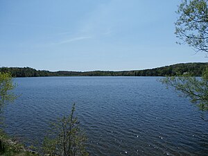
Stoke Lake
Lake in Quebec, Canada
Distance: Approx. 8395 meters
Latitude and longitude: 45.516379,-71.808967
The lake Stoke (in French: lac Stoke) is the source of Stoke River. This lake is located south of the municipality of Stoke in the Le Val-Saint-François Regional County Municipality (MRC), in administrative region of Estrie, in Quebec, Canada.
Weather in this IP's area
clear sky
15 Celsius
16 Celsius
15 Celsius
17 Celsius
1018 hPa
97 %
1018 hPa
1000 hPa
10000 meters
1.03 m/s
110 degree
06:29:45
18:52:26