Country:
 USA
USARegion:
City:
Latitude and Longitude:
Time Zone:
Postal Code:
IP information under different IP Channel
ip-api
Country
Region
City
ASN
Time Zone
ISP
Blacklist
Proxy
Latitude
Longitude
Postal
Route
IPinfo
Country
Region
City
ASN
Time Zone
ISP
Blacklist
Proxy
Latitude
Longitude
Postal
Route
MaxMind
Country
Region
City
ASN
Time Zone
ISP
Blacklist
Proxy
Latitude
Longitude
Postal
Route
Luminati
Country
USRegion
id
City
kuna
ASN
Time Zone
America/Boise
ISP
ANTHEMBB
Latitude
Longitude
Postal
db-ip
Country
Region
City
ASN
Time Zone
ISP
Blacklist
Proxy
Latitude
Longitude
Postal
Route
ipdata
Country
Region
City
ASN
Time Zone
ISP
Blacklist
Proxy
Latitude
Longitude
Postal
Route
Popular places and events near this IP address

Kuna, Idaho
City in Ada County, Idaho, United States
Distance: Approx. 3120 meters
Latitude and longitude: 43.49305556,-116.41888889
Kuna ( KYOO-nə) is a city in Ada County, Idaho. It is part of the Boise metropolitan area. The population was 24,011 at the time of the 2020 census.

Boise metropolitan area
Metropolitan Statistical Area in the United States
Distance: Approx. 9677 meters
Latitude and longitude: 43.5,-116.5
The Boise, Idaho Metropolitan Statistical Area (MSA) (commonly known as the Boise Metropolitan Area or the Treasure Valley) is an area that encompasses Ada, Boise, Canyon, Gem, and Owyhee counties in southwestern Idaho, anchored by the cities of Boise and Nampa. It is the main component of the wider Boise–Mountain Home–Ontario, ID–OR Combined Statistical Area, which adds Elmore and Payette counties in Idaho and Malheur County, Oregon. It is the state's largest officially designated metropolitan area and includes Idaho's three largest cities: Boise, Nampa, and Meridian.

Kuna Caves
Distance: Approx. 9734 meters
Latitude and longitude: 43.41213889,-116.44972222
Kuna Caves are lava tubes found south of Kuna, Idaho. There is currently one publicly known entrance to the cave, an opening in the ground with a caged ladder leading down into the cave.
KBOI (AM)
Radio station in Idaho, United States
Distance: Approx. 7517 meters
Latitude and longitude: 43.42877778,-116.32956111
KBOI (670 kHz) is a commercial AM radio station in Boise, Idaho. It is owned by Cumulus Media and it simulcasts a news/talk radio format with co-owned 93.1 KBOI-FM. Studios and offices are on Bannock Street in Downtown Boise, while the AM transmitter site with its six-tower array is on Cloverdale Road in Kuna. KBOI is Idaho's most powerful AM station, broadcasting with 50,000 watts around the clock.

KIDO
Radio station in Nampa–Boise, Idaho
Distance: Approx. 8507 meters
Latitude and longitude: 43.55960833,-116.40151389
KIDO (580 AM) is a commercial radio station, owned and operated by Townsquare Media, which broadcasts a news/talk format. Licensed to Nampa, Idaho, it serves the Boise metropolitan area. KIDO's studios are located at 827 East Park Blvd.
KTIK (AM)
Radio station in Boise, Idaho
Distance: Approx. 7586 meters
Latitude and longitude: 43.54944444,-116.41055556
KTIK (1350 kHz, "95.3 The Ticket") is a commercial AM radio station located in Boise, Idaho, United States. KTIK airs sports talk programming as a Infinity Sports Network affiliate and is under ownership of Cumulus Media.

Southwestern Idaho
Region in Idaho, United States
Distance: Approx. 9677 meters
Latitude and longitude: 43.5,-116.5
Southwestern Idaho is a geographical term for the area along the U.S. state of Idaho's borders with Oregon and Nevada. It includes the populous areas of the Boise metropolitan area and the Treasure Valley. The counties of Ada, Adams, Boise, Canyon, Elmore, Gem, Owyhee, Payette, Valley, and Washington are included in the region.

KDBI (AM)
Radio station in Boise, Idaho
Distance: Approx. 5532 meters
Latitude and longitude: 43.51555556,-116.32861111
KDBI (730 kHz) was an AM radio station in Boise, Idaho.
KFXD
Radio station in Idaho. United States
Distance: Approx. 5223 meters
Latitude and longitude: 43.51563889,-116.33372222
KFXD (630 AM) is a commercial radio station, owned by Townsquare Media, which airs a rhythmic contemporary format branded as "Power 105.5". The station is licensed to serve Boise, Idaho.
Kuna High School
Public high school in Kuna, Idaho, United States
Distance: Approx. 2742 meters
Latitude and longitude: 43.502,-116.406
Kuna High School is a public high school in Kuna, Idaho, the only traditional high school in the Kuna Joint School District #3, located in southwest Ada County, west of Boise and south of Meridian. The school colors are black and gold and the mascot is a Kaveman.
Northwest Lineman College
Vocational college in the United States
Distance: Approx. 5779 meters
Latitude and longitude: 43.53583333,-116.39277778
Northwest Lineman College, founded in 1993, is a private vocational technical college offering training programs with a concentration on careers in the power delivery industry. The main campus is located in Meridian, Idaho and branch campuses are located in Oroville, California, Denton, Texas and Edgewater, Florida. Northwest Lineman College offers technical certificate training programs for those seeking a career in the power delivery industry, and also for people working in the industry seeking trade-specific certifications.
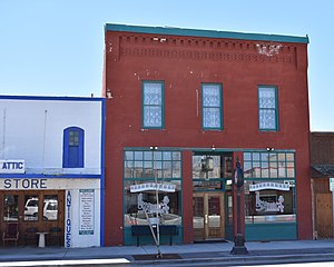
Lilyquist-Christianson Building
United States historic place
Distance: Approx. 2937 meters
Latitude and longitude: 43.49055556,-116.4175
The Lilyquist-Christianson Building in Kuna, Idaho, is a 2-story brick building constructed by Charles Lilyquist in 1909. The building features a decorative brick cornice with raised corbeling between end brackets below a flat parapet roof. Three symmetrical double hung sash windows are above a central, inset entry between two commercial display windows.
Weather in this IP's area
clear sky
17 Celsius
16 Celsius
16 Celsius
19 Celsius
1020 hPa
34 %
1020 hPa
927 hPa
10000 meters
0.45 m/s
0.45 m/s
14 degree
07:48:08
19:19:07