Country:
 USA
USARegion:
City:
Latitude and Longitude:
Time Zone:
Postal Code:
IP information under different IP Channel
ip-api
Country
Region
City
ASN
Time Zone
ISP
Blacklist
Proxy
Latitude
Longitude
Postal
Route
IPinfo
Country
Region
City
ASN
Time Zone
ISP
Blacklist
Proxy
Latitude
Longitude
Postal
Route
MaxMind
Country
Region
City
ASN
Time Zone
ISP
Blacklist
Proxy
Latitude
Longitude
Postal
Route
Luminati
Country
USRegion
id
City
saintanthony
ASN
Time Zone
America/Boise
ISP
ANTHEMBB
Latitude
Longitude
Postal
db-ip
Country
Region
City
ASN
Time Zone
ISP
Blacklist
Proxy
Latitude
Longitude
Postal
Route
ipdata
Country
Region
City
ASN
Time Zone
ISP
Blacklist
Proxy
Latitude
Longitude
Postal
Route
Popular places and events near this IP address

Parker, Idaho
City in Idaho, United States
Distance: Approx. 4944 meters
Latitude and longitude: 43.95861111,-111.75916667
Parker is a city in southeastern Fremont County, Idaho, United States. The population was 305 at the 2010 census. It is part of the Rexburg, Idaho Micropolitan Statistical Area.

St. Anthony, Idaho
City in Idaho, United States
Distance: Approx. 1242 meters
Latitude and longitude: 43.96611111,-111.68444444
St. Anthony is a city in and the county seat of Fremont County, Idaho, United States. The population was 3,542 at the 2010 census, up from 3,342 in 2000.

Teton, Idaho
City in Idaho, United States
Distance: Approx. 8365 meters
Latitude and longitude: 43.88777778,-111.66916667
Teton is a city in Fremont County, Idaho, United States. The population was 735 at the 2010 census. It is part of the Rexburg, Idaho Micropolitan Statistical Area.

South Fremont High School
Public school in St. Anthony, Idaho, United States
Distance: Approx. 1980 meters
Latitude and longitude: 43.975,-111.684
South Fremont High School is a four-year public secondary school in St. Anthony, Idaho, United States. It is one of two high schools in the Fremont School District #215.

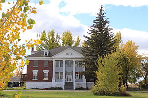
Fremont County Courthouse (Idaho)
United States historic place
Distance: Approx. 1403 meters
Latitude and longitude: 43.96777778,-111.68361111
Fremont County Courthouse in St. Anthony, Idaho was built in 1909. It was listed on the National Register of Historic Places in 1979.

Sand Creek Wildlife Management Area
Wildlife area near St. Anthony, Idaho
Distance: Approx. 8813 meters
Latitude and longitude: 44.037978,-111.717301
Sand Creek Wildlife Management Area at 31,000 acres (130 km2) is an Idaho wildlife management area in Fremont County near the town of St. Anthony. The WMA was established in 1947 when the Chapman Ranch was acquired with federal funds.
Idaho State Industrial School Women's Dormitory
United States historic place
Distance: Approx. 1196 meters
Latitude and longitude: 43.96944444,-111.70486111
The Idaho State Industrial School Women's Dormitory in St. Anthony, Idaho was completed in 1924 from 1920 plans designed by the architectural firm Tourtellotte & Hummel. It was listed on the National Register of Historic Places on November 17, 1982.
Wilford, Idaho
Unincorporated community in the state of Idaho, United States
Distance: Approx. 5500 meters
Latitude and longitude: 43.91277778,-111.67777778
Wilford is an unincorporated community in Fremont County, in the U.S. state of Idaho.

St. Anthony Pegram Truss Railroad Bridge
United States historic place
Distance: Approx. 1867 meters
Latitude and longitude: 43.95027778,-111.71638889
The St. Anthony Pegram Truss Railroad Bridge, in Fremont County, Idaho near St. Anthony, Idaho, was built in 1896.
Weather in this IP's area
clear sky
13 Celsius
11 Celsius
12 Celsius
13 Celsius
1022 hPa
38 %
1022 hPa
857 hPa
10000 meters
2.06 m/s
180 degree
07:29:40
19:00:07