Country:
Region:
City:
Latitude and Longitude:
Time Zone:
Postal Code:
IP information under different IP Channel
ip-api
Country
Region
City
ASN
Time Zone
ISP
Blacklist
Proxy
Latitude
Longitude
Postal
Route
IPinfo
Country
Region
City
ASN
Time Zone
ISP
Blacklist
Proxy
Latitude
Longitude
Postal
Route
MaxMind
Country
Region
City
ASN
Time Zone
ISP
Blacklist
Proxy
Latitude
Longitude
Postal
Route
Luminati
Country
Region
id
City
blackfoot
ASN
Time Zone
America/Boise
ISP
ANTHEMBB
Latitude
Longitude
Postal
db-ip
Country
Region
City
ASN
Time Zone
ISP
Blacklist
Proxy
Latitude
Longitude
Postal
Route
ipdata
Country
Region
City
ASN
Time Zone
ISP
Blacklist
Proxy
Latitude
Longitude
Postal
Route
Popular places and events near this IP address

Blackfoot, Idaho
City in Idaho, United States
Distance: Approx. 1937 meters
Latitude and longitude: 43.19,-112.34611111
Blackfoot is a city and county seat of Bingham County, Idaho, United States. The population was 12,346 at the 2020 census. Blackfoot is the principal city of the Blackfoot, Idaho, Micropolitan Statistical Area, which includes Bingham County.

Idaho Potato Museum
Museum in Blackfoot, Idaho, United States
Distance: Approx. 2135 meters
Latitude and longitude: 43.18944444,-112.34361111
The Idaho Potato Museum is a museum devoted to the potato, located in Blackfoot, Idaho.
Eastern Idaho State Fair
Distance: Approx. 2069 meters
Latitude and longitude: 43.19472222,-112.34055556
The Eastern Idaho State Fair is an American state fair held annually the first week of September in Blackfoot, Idaho. It is one of three annual state fairs in Idaho; the others being the Western Idaho Fair, which is held in Boise, the state capital, and the Northern Idaho State fair, held in Coeur d’Alene. The gates to the fairgrounds open on Labor Day weekend, the first week in September.

United States Post Office–Blackfoot Main
United States historic place
Distance: Approx. 1952 meters
Latitude and longitude: 43.19083333,-112.345
The U.S. Post Office–Blackfoot Main, also known as Blackfoot Main Post Office, in Blackfoot, Idaho was built in 1936. It was listed on the National Register of Historic Places in 1989. It has Moderne architecture.

Groveland, Idaho
Census-designated place in Bingham County, Idaho, United States
Distance: Approx. 2202 meters
Latitude and longitude: 43.22,-112.3725
Groveland is a census-designated place in Bingham County, Idaho, United States. Its population was 877 as of the 2010 census. The community was named for the groves of trees near the original town site.

Blackfoot LDS Tabernacle
Historic church in Idaho, United States
Distance: Approx. 2385 meters
Latitude and longitude: 43.18666667,-112.34277778
The Blackfoot LDS Tabernacle, also known as the Blackfoot Tabernacle or South Blackfoot Stake Tabernacle is a building located in Blackfoot, Idaho that formerly served as a tabernacle for large gatherings of members of the Church of Jesus Christ of Latter-day Saints (LDS Church). The tabernacle was designed by architects Hyrum Pope and Harold W. Burton and completed in 1921. The building was listed on the National Register of Historic Places in 1977.

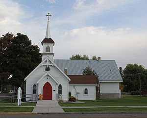
Ross Fork Episcopal Church
Historic church in Idaho, United States
Distance: Approx. 2098 meters
Latitude and longitude: 43.18972222,-112.34388889
Ross Fork Episcopal Church (also known as Good Shepherd Mission) is a historic church on Mission Road in Fort Hall, Idaho, in the Fort Hall Reservation. It was added to the National Register of Historic Places in 1983. The church was built in 1904 as the Good Shepherd Mission, and was intended to educate the native population.

St. Paul's Episcopal Church (Blackfoot, Idaho)
Historic church in Idaho, United States
Distance: Approx. 2372 meters
Latitude and longitude: 43.18805556,-112.34138889
St. Paul's Episcopal Church is a historic church at 72 N. Shilling Avenue in Blackfoot, Idaho. It was started in 1891 and was added to the National Register in 1979.
Bingham Memorial Hospital
Hospital in Idaho, United States
Distance: Approx. 1683 meters
Latitude and longitude: 43.19334,-112.3467
Bingham Memorial Hospital is a hospital in Bingham County, Idaho, United States, that was established in 1950.

Blackfoot I.O.O.F. Hall
United States historic place
Distance: Approx. 2064 meters
Latitude and longitude: 43.18944444,-112.34472222
The Blackfoot I.O.O.F. Hall, at 57 Bridge St. in Blackfoot, Idaho, was built in 1905. Its rear wall shows rough lava-rock structural fabric, while the front, brick facade is refined and survives about storefronts on the ground level.

Idaho Republican Building
United States historic place
Distance: Approx. 1972 meters
Latitude and longitude: 43.19,-112.34555556
The Idaho Republican Building, at 167 W. Bridge St. in Blackfoot, Idaho, was built in 1916. It was listed on the National Register of Historic Places in 1979.
Collins, Idaho
Unincorporated community in Bingham County, Idaho, United States
Distance: Approx. 928 meters
Latitude and longitude: 43.20222222,-112.37583333
Collins is an unincorporated community in Bingham County, Idaho, United States. Collins is located on U.S. Route 26 immediately west of Blackfort and Interstate 15.
Weather in this IP's area
clear sky
14 Celsius
12 Celsius
12 Celsius
15 Celsius
1022 hPa
26 %
1022 hPa
870 hPa
10000 meters
2.81 m/s
2.96 m/s
188 degree
07:31:53
19:03:14