Country:
 USA
USARegion:
City:
Latitude and Longitude:
Time Zone:
Postal Code:
IP information under different IP Channel
ip-api
Country
Region
City
ASN
Time Zone
ISP
Blacklist
Proxy
Latitude
Longitude
Postal
Route
IPinfo
Country
Region
City
ASN
Time Zone
ISP
Blacklist
Proxy
Latitude
Longitude
Postal
Route
MaxMind
Country
Region
City
ASN
Time Zone
ISP
Blacklist
Proxy
Latitude
Longitude
Postal
Route
Luminati
Country
USRegion
id
City
emmett
ASN
Time Zone
America/Boise
ISP
ANTHEMBB
Latitude
Longitude
Postal
db-ip
Country
Region
City
ASN
Time Zone
ISP
Blacklist
Proxy
Latitude
Longitude
Postal
Route
ipdata
Country
Region
City
ASN
Time Zone
ISP
Blacklist
Proxy
Latitude
Longitude
Postal
Route
Popular places and events near this IP address

Emmett, Idaho
City in Idaho, United States
Distance: Approx. 4238 meters
Latitude and longitude: 43.87277778,-116.495
Emmett is a city in Gem County, Idaho, United States. The population was 6,557 at the 2010 census, up from 5,490 in 2000. It is the county seat and the only city in the county.
Emmett High School
Public school in Emmett, Idaho, United States
Distance: Approx. 5430 meters
Latitude and longitude: 43.864,-116.509
Emmett High School is a four-year public secondary school in Emmett, Idaho, the only traditional high school in the Emmett School District #221. The school colors are royal blue and white and the mascot is a husky. Red is the accent color.
KQXR
Radio station in Payette, Idaho
Distance: Approx. 9663 meters
Latitude and longitude: 43.825,-116.509
KQXR is a commercial radio station licensed in Payette, Idaho, broadcasting to the Boise, Idaho metro area on 100.3 FM. The station is owned by Lotus Communications with studios located at 5257 Fairview Avenue #260, Boise, Idaho 83706. "The X"—as the station is commonly known, plays an active rock radio format and positions themselves as "100.3 The X...Rocks." The station was a finalist for Radio and Records magazine's 2007 Industry Achievement Award for best Alternative Station for markets 100 and up. Other finalists include WKZQ-FM, WJSE, WBTZ, KXNA, and WSFM. The station won the "Small Market Radio Station of the Year" at the RadioContraband Rock Radio Convention in 2017.
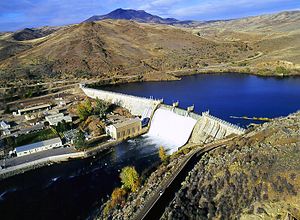
Black Canyon Diversion Dam
Dam in Gem County, Idaho, US
Distance: Approx. 4766 meters
Latitude and longitude: 43.93046,-116.43635
Black Canyon Diversion Dam (National Inventory of Dams ID ID00282) is a dam in Gem County, Idaho. The concrete dam was originally completed in 1924, then re-constructed between 1951 and 1955, by the United States Bureau of Reclamation. Its structure has a height of 183 feet (56 m), and a length of 1,902 feet (580 m) at its crest.

Emmett Presbyterian Church
Historic church in Idaho, United States
Distance: Approx. 4204 meters
Latitude and longitude: 43.873332,-116.497492
The Emmett Presbyterian Church, also known as Emmett First Southern Baptist Church, is a historic formerly Presbyterian church building at 2nd Street in Emmett, Idaho. It was started in 1909 in a late-Gothic Revival style and was added to the National Register of Historic Places in 1980. It was the first church building of the Emmett Presbyterian Church, which was founded in 1906.

Gem County Courthouse
United States historic place
Distance: Approx. 3966 meters
Latitude and longitude: 43.87525,-116.495106
The Gem County Courthouse, located at the intersection of Main St. and McKinley Ave. in Emmett, serves Gem County, Idaho.

First Baptist Church of Emmett
United States historic place
Distance: Approx. 4063 meters
Latitude and longitude: 43.87472222,-116.49833333
The First Baptist Church of Emmett, at the northeast corner of 1st St. and Hayes Ave. in Emmett, Idaho, was built in 1915.
Catholic Church of the Sacred Heart (Emmett, Idaho)
United States historic place
Distance: Approx. 4113 meters
Latitude and longitude: 43.87416667,-116.4975
The Catholic Church of the Sacred Heart, on 1st St. in Emmett, Idaho, was listed on the National Register of Historic Places in 1980. It was designed by architects Tourtellotte & Hummel in Mission Revival style.
Methodist Episcopal Church (Emmett, Idaho)
United States historic place
Distance: Approx. 4068 meters
Latitude and longitude: 43.87472222,-116.49861111
The Methodist Episcopal Church in Emmett, Idaho, was built in 1906. It was listed on the National Register of Historic Places in 1980. It has also been known as the United Methodist Church.

St. Mary's Episcopal Church (Emmett, Idaho)
United States historic place
Distance: Approx. 4082 meters
Latitude and longitude: 43.87444444,-116.4975
The St. Mary's Episcopal Church, on 1st St. in Emmett, Idaho, was listed on the National Register of Historic Places in 1980.
Weather in this IP's area
clear sky
14 Celsius
12 Celsius
12 Celsius
16 Celsius
1021 hPa
32 %
1021 hPa
933 hPa
10000 meters
1.34 m/s
3.13 m/s
94 degree
07:48:49
19:19:17