Country:
Region:
City:
Latitude and Longitude:
Time Zone:
Postal Code:
IP information under different IP Channel
ip-api
Country
Region
City
ASN
Time Zone
ISP
Blacklist
Proxy
Latitude
Longitude
Postal
Route
Luminati
Country
Region
il
City
sherman
ASN
Time Zone
America/Chicago
ISP
CASSCOMM
Latitude
Longitude
Postal
IPinfo
Country
Region
City
ASN
Time Zone
ISP
Blacklist
Proxy
Latitude
Longitude
Postal
Route
db-ip
Country
Region
City
ASN
Time Zone
ISP
Blacklist
Proxy
Latitude
Longitude
Postal
Route
ipdata
Country
Region
City
ASN
Time Zone
ISP
Blacklist
Proxy
Latitude
Longitude
Postal
Route
Popular places and events near this IP address

Sherman, Illinois
Village in Illinois, United States
Distance: Approx. 2924 meters
Latitude and longitude: 39.89222222,-89.60472222
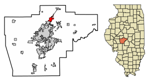
Sherman is a village in Sangamon County, Illinois, United States. The population was 4,673 at the 2020 census. It is part of the Springfield, Illinois Metropolitan Statistical Area.

Spaulding, Illinois
Village in Illinois, United States
Distance: Approx. 6314 meters
Latitude and longitude: 39.86527778,-89.54166667
Spaulding is a village in Sangamon County, Illinois, United States. The population was 873 at the 2010 census. It is part of the Springfield, Illinois Metropolitan Statistical Area.

Williamsville, Illinois
Village in Illinois, United States
Distance: Approx. 5074 meters
Latitude and longitude: 39.95083333,-89.55083333
Williamsville is a village in Sangamon County, Illinois, United States. The population was 1,476 at the 2010 census, and 1,491 at a 2018 estimate. It is part of the Springfield, Illinois Metropolitan Statistical Area.

Fancy Creek Township, Sangamon County, Illinois
Township in Illinois, United States
Distance: Approx. 6601 meters
Latitude and longitude: 39.91833333,-89.65972222
Fancy Creek Township is located in Sangamon County, Illinois. As of the 2010 census, its population was 5,410 and it contained 2,074 housing units. Fancy Creek Township changed its name from Power Township on September 11, 1861.

Williams Township, Sangamon County, Illinois
Township in Illinois, United States
Distance: Approx. 3519 meters
Latitude and longitude: 39.925,-89.545
Williams Township is located in Sangamon County, Illinois. As of the 2010 census, its population was 3,446 and it contained 1,332 housing units.
Andrew, Illinois
Unincorporated community in Illinois, United States
Distance: Approx. 5232 meters
Latitude and longitude: 39.89555556,-89.64
Andrew is an unincorporated community in Fancy Creek Township, Sangamon County, Illinois, United States. Andrew is located on the Illinois and Midland Railroad 1.9 miles (3.1 km) west of Sherman.
Barclay, Illinois
Unincorporated community in Illinois, United States
Distance: Approx. 6959 meters
Latitude and longitude: 39.87472222,-89.51777778
Barclay is an unincorporated community in Clear Lake and Williams townships, Sangamon County, Illinois, United States. Barclay is located on Illinois Route 54 and the Canadian National Railway, 1.3 miles (2.1 km) northeast of Spaulding.
Bissell, Illinois
Unincorporated community in Illinois, United States
Distance: Approx. 7380 meters
Latitude and longitude: 39.84611111,-89.58166667
Bissell is an unincorporated community in Clear Lake Township, Sangamon County, Illinois, United States. Bissell is located on Illinois Route 54 and the Canadian National Railway near the northeast border of Springfield.
Spring Creek (Sangamon County, Illinois)
River
Distance: Approx. 7726 meters
Latitude and longitude: 39.8597722,-89.6417678
Spring Creek is a tributary of the Sangamon River in the U.S. state of Illinois. After rising in Morgan County, it flows into Sangamon County and discharges into the Sangamon River. In the lower part of its course, it flows through the city of Springfield, bordering Springfield's Oak Ridge Cemetery and the tomb of Abraham Lincoln.

Price-Prather House
Historic house in Illinois, United States
Distance: Approx. 5644 meters
Latitude and longitude: 39.95472222,-89.54638889
The Price-Prather House is a historic house located at the intersection of Main and Elkhart Streets in Williamsville, Illinois. The house was built in 1868 for livestock breeder James R. Price. The Italianate house features a multi-component slate roof, a bracketed and dentillated cornice, a wraparound front porch, and long arched windows with brick hoods.

Cornelius Flagg Farmstead
United States historic place
Distance: Approx. 3704 meters
Latitude and longitude: 39.89083333,-89.61583333
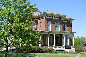
The Cornelius Flagg Farmstead is a historic farm located on Tipton School Road in Sherman, Illinois. Cornelius Flagg, a farmer and lumber businessman from Ohio, established the farm in the 1870s. The farmhouse, the farm's main building, is a two-story brick Italianate building.

Power Farmstead
United States historic place
Distance: Approx. 7668 meters
Latitude and longitude: 39.94416667,-89.6625
The Power Farmstead is a historic farm located on County Road 9500N east of Cantrall, Illinois. George Power, a prominent early settler of northern Sangamon County, established the farm in the 1820s. The farm includes an intact collection of buildings which represent typical 19th-century farm life.
Weather in this IP's area
mist
18 Celsius
18 Celsius
18 Celsius
18 Celsius
1010 hPa
91 %
1010 hPa
990 hPa
6437 meters
4.12 m/s
190 degree
100 %
06:31:14
16:52:33