Country:
 France
Region:
City:
Latitude and Longitude:
Time Zone:
Postal Code:
IP information under different IP Channel
ip-api
Country
Region
City
ASN
Time Zone
ISP
Blacklist
Proxy
Latitude
Longitude
Postal
Route
IPinfo
Country
Region
City
ASN
Time Zone
ISP
Blacklist
Proxy
Latitude
Longitude
Postal
Route
MaxMind
Country
Region
City
ASN
Time Zone
ISP
Blacklist
Proxy
Latitude
Longitude
Postal
Route
Luminati
Country
FRRegion
pac
City
marseille
ASN
Time Zone
Europe/Paris
ISP
Free Pro SAS
Latitude
Longitude
Postal
db-ip
Country
Region
City
ASN
Time Zone
ISP
Blacklist
Proxy
Latitude
Longitude
Postal
Route
ipdata
Country
Region
City
ASN
Time Zone
ISP
Blacklist
Proxy
Latitude
Longitude
Postal
Route
Popular places and events near this IP address

L'Estaque
Distance: Approx. 3551 meters
Latitude and longitude: 43.36138889,5.31416667
L'Estaque (French pronunciation: [lɛstak]; Occitan: L'Estaca) is a village in southern France, just west of Marseille. Administratively, it belongs to the commune of Marseille.

Septèmes-les-Vallons
Commune in Provence-Alpes-Côte d'Azur, France
Distance: Approx. 3011 meters
Latitude and longitude: 43.3992,5.3667
Septèmes-les-Vallons (French pronunciation: [sɛptɛm le valɔ̃]) is a commune in the Bouches-du-Rhône department in southern France. It is located 10.7 km (6.5 mi) north from the centre of Marseille.

15th arrondissement of Marseille
Municipal arrondissement in Provence-Alpes-Côte d'Azur, France
Distance: Approx. 1603 meters
Latitude and longitude: 43.3628,5.3678
The 15th arrondissement of Marseille is one of the 16 arrondissements of Marseille. It is governed locally together with the 16th arrondissement, with which it forms the 8th sector of Marseille.

16th arrondissement of Marseille
Municipal arrondissement in Provence-Alpes-Côte d'Azur, France
Distance: Approx. 4026 meters
Latitude and longitude: 43.3753,5.305
The 16th arrondissement of Marseille is one of the 16 arrondissements of Marseille. It is governed locally together with the 15th arrondissement, with which it forms the 8th sector of Marseille.

La Castellane
Neighbourhood in the 16th arrondissement of Marseille, France
Distance: Approx. 1263 meters
Latitude and longitude: 43.367,5.342
La Castellane is a neighbourhood in the 16th arrondissement of Marseille, France. Built as a Modernist council estate in the 1960s for French refugees of the Algerian War of 1954–1962, it is now home to about 7,000 residents, many of whom are second-generation French citizens. The neighbourhood is plagued by unemployment, drug trafficking, prostitution, and arms smuggling.
Bastide de la Guillermy
Historic building in Marseille, France
Distance: Approx. 1892 meters
Latitude and longitude: 43.3578,5.3633
The Bastide de la Guillermy is a historic bastide in Les Aygalades, a neighbourhood in the 15th arrondissement of Marseille, France. It was built in the 17th century, making it one of the oldest buildings in Marseille.

Villa La Palestine
Historic mansion in Marseille, Bouches-du-Rhône, France
Distance: Approx. 3680 meters
Latitude and longitude: 43.3611,5.3126
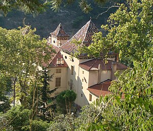
Villa La Palestine is a historic mansion in Marseille, Bouches-du-Rhône, France. It was built from 1902 to 1905 for Pierre Leclerc. It has been listed as an official historical monument since November 16, 1993.

Église Saint-Louis
Church in Provence-Alpes-Côte d'Azur, France
Distance: Approx. 2818 meters
Latitude and longitude: 43.3484,5.358
The Église Saint-Louis is a historic Roman Catholic church in the 15th arrondissement of Marseille, France. It was designed in the Bauhaus architectural style by Jean-Louis Sourdeau, with additional sculptures designed by Carlo Sarrabezoles. Its construction was completed in 1935.
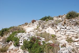
Oppidum de Verduron
Distance: Approx. 1294 meters
Latitude and longitude: 43.3714,5.339
The Oppidum de Verduron is an oppidum in the 15th arrondissement of Marseille, Southern France. It was built in the Iron Age. It was discovered in 1906, but not fully excavated until 1911.
Lycée Saint-Exupéry (Marseille)
Public school in Marseille, France
Distance: Approx. 2995 meters
Latitude and longitude: 43.3467,5.3542
Lycée Saint-Exupéry, nicknamed Saint-Ex, is a sixth-form college/senior high school in the 15th arrondissement of Marseille, France. As of 2013 the attendance zone of Saint-Exupéry covers those of nine different junior high schools (collèges).
École Tour-Sainte
Distance: Approx. 4279 meters
Latitude and longitude: 43.3441,5.3886
École Tour-Sainte is a Catholic preschool, primary, junior high, and sixth-form college/senior high school in the 14th arrondissement of Marseille of Marseille, France. As of 2015 there were about 750 students; circa 2018 there were about 760 students total; 210 students in preschool and primary school, 400 in junior high school, and 150 in sixth-form/senior high school. In 2015 about 75% of the students were Muslim.

Société Coloniale des Chaux et Ciments de Portland de Marseille
Distance: Approx. 4056 meters
Latitude and longitude: 43.36769883,5.30523603
The Société Coloniale des Chaux et Ciments de Portland de Marseille (Colonial Company for Lime and Portland Cements in Marseille) owned and operated cement works in L'Estaque near Marseille in the department of Bouches-du-Rhône.
Weather in this IP's area
scattered clouds
17 Celsius
16 Celsius
17 Celsius
17 Celsius
1016 hPa
66 %
1016 hPa
998 hPa
10000 meters
4.63 m/s
280 degree
40 %
07:56:15
18:50:46