38.124.190.55 - IP Lookup: Free IP Address Lookup, Postal Code Lookup, IP Location Lookup, IP ASN, Public IP
Country:
 USA
USARegion:
City:
Location:
Time Zone:
Postal Code:
ISP:
ASN:
language:
User-Agent:
Proxy IP:
Blacklist:
IP information under different IP Channel
ip-api
Country
Region
City
ASN
Time Zone
ISP
Blacklist
Proxy
Latitude
Longitude
Postal
Route
db-ip
Country
Region
City
ASN
Time Zone
ISP
Blacklist
Proxy
Latitude
Longitude
Postal
Route
IPinfo
Country
Region
City
ASN
Time Zone
ISP
Blacklist
Proxy
Latitude
Longitude
Postal
Route
IP2Location
38.124.190.55Country
usRegion
maryland
City
chestertown
Time Zone
America/New_York
ISP
Language
User-Agent
Latitude
Longitude
Postal
ipdata
Country
Region
City
ASN
Time Zone
ISP
Blacklist
Proxy
Latitude
Longitude
Postal
Route
Popular places and events near this IP address
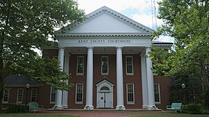
Kent County, Maryland
County in Maryland, United States
Distance: Approx. 3756 meters
Latitude and longitude: 39.23,-76.1
Kent County is a county located in the U.S. state of Maryland. As of the 2020 census, its population was 19,198, making it the least populous county in Maryland. Its county seat is Chestertown.

Battle of Caulk's Field
Battle of the War of 1812
Distance: Approx. 5020 meters
Latitude and longitude: 39.22440833,-76.18589444
The Battle of Caulk's Field was fought during the War of 1812 in Kent County, Maryland, United States, between a small British Army force commanded by Captain Sir Peter Parker and American militia forces commanded by Lieutenant Colonel Philip Reed. Parker, who was operating in the Chesapeake Bay region as part of the British campaign against Baltimore, Maryland, landed on the eastern shore of the Chesapeake Bay to move against Reed's militia encampment. The British attacking force encountered American skirmishers, who conducting a fighting retreat, drawing the British towards the main American line.
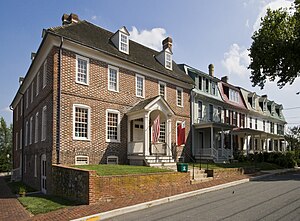
Chestertown Historic District (Chestertown, Maryland)
Historic district in Maryland, United States
Distance: Approx. 5436 meters
Latitude and longitude: 39.2125,-76.06944444
Chestertown Historic District is a historic district in Chestertown, Maryland. It was listed on the National Register of Historic Places and designated a National Historic Landmark in 1970, and its area was increased in 1984. The town on the Chester River, became the chief port for tobacco and wheat on the Eastern Shore of Maryland between 1750 and 1790.

Airy Hill
Historic house in Maryland
Distance: Approx. 3710 meters
Latitude and longitude: 39.19277778,-76.09333333
Airy Hill is a historic home located at Chestertown, Kent County, Maryland, United States. It is a two-section dwelling consisting of a 1+1⁄2-story frame wing and a two-story Federal-style brick house. The brick section was added in the early 1790s, together with a middle section that now connects the two.

Brampton (Chestertown, Maryland)
Historic house in Maryland
Distance: Approx. 3196 meters
Latitude and longitude: 39.21194444,-76.09555556
Brampton is a historic home located at Chestertown, Kent County, Maryland. It is a transitional Greek Revival / Italianate-influenced dwelling built about 1860. The main section of the house is a three-story structure, constructed of brick with a symmetrical five-bay-wide facade and a depth of two bays.

Chestertown station
United States historic place
Distance: Approx. 5453 meters
Latitude and longitude: 39.20777778,-76.06888889
Chestertown is a historic railway station built in 1902–03 for the Pennsylvania Railroad and located in Chestertown, Kent County, Maryland. It is a 1+1⁄2-story, 17-by-47-foot (5.2 by 14.3 m) Queen Anne–style building. It features a hip roof with a wide bracketed overhang that provided shelter for train passengers on all four sides.
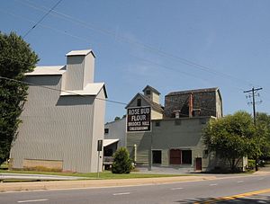
Radcliffe Mill
United States historic place
Distance: Approx. 4664 meters
Latitude and longitude: 39.21916667,-76.08027778
The Radcliffe Mill is a historic grist mill and related structures located in Chestertown, Kent County, Maryland, United States. It consists of a Mill Building, built in 1891; Grain Elevator, probably constructed around 1924; and Annex / Seed House. The complex is historically significant for its association with the development of agriculture and the associated grist milling industry in Kent County.

St. Paul's Church (Fairlee, Maryland)
Historic church in Maryland, United States
Distance: Approx. 4717 meters
Latitude and longitude: 39.18638889,-76.17972222
St. Paul's Church is an historic Episcopal church located near the village of Fairlee, southwest of Chestertown, Kent County, Maryland. St.
Fairlee, Maryland
Census-designated place in Maryland, United States
Distance: Approx. 3835 meters
Latitude and longitude: 39.2225,-76.17194444
Fairlee is an unincorporated community and census-designated place in Kent County, Maryland, United States. Its population was 490 as of the 2010 census. The Battle of Caulk's Field during the War of 1812 took place near Fairlee on August 31, 1814; it ended in victory for the local militia, and the British commander was killed during the fighting.
Pomona, Maryland
Unincorporated community in Maryland, U.S.
Distance: Approx. 5366 meters
Latitude and longitude: 39.16222222,-76.10972222
Pomona is an unincorporated community in Kent County, Maryland, United States. It is located at the intersection of MD-289 (Quaker Neck Road) and Pomona Road, 4.5 miles southwest of Chestertown. Pomona is home to the last remaining country store in Kent County.
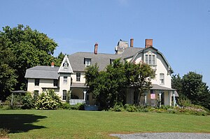
Lauretum
Historic house in Maryland, United States
Distance: Approx. 4240 meters
Latitude and longitude: 39.21944444,-76.08555556
Lauretum is a historic home located at Chestertown, Kent County, Maryland, United States. It is a large, three story late Victorian stuccoed frame house built in 1881 for Chestertown lawyer Harrison W. Vickers (1845-1911). Restored by Jennifer Corcoran and Family.
Langford, Maryland
Unincorporated community in Maryland, United States
Distance: Approx. 2231 meters
Latitude and longitude: 39.18833333,-76.14083333
Langford is an unincorporated community in Kent County, Maryland, United States. Langford is located along Maryland Route 446 on Broad Neck, 4.25 miles (6.84 km) west-southwest of Chestertown.
Weather in this IP's area
overcast clouds
8 Celsius
5 Celsius
7 Celsius
8 Celsius
1022 hPa
47 %
1022 hPa
1021 hPa
10000 meters
6.08 m/s
10.4 m/s
328 degree
100 %