38.107.148.241 - IP Lookup: Free IP Address Lookup, Postal Code Lookup, IP Location Lookup, IP ASN, Public IP
Country:
 USA
USARegion:
City:
Location:
Time Zone:
Postal Code:
ISP:
ASN:
language:
User-Agent:
Proxy IP:
Blacklist:
IP information under different IP Channel
ip-api
Country
Region
City
ASN
Time Zone
ISP
Blacklist
Proxy
Latitude
Longitude
Postal
Route
db-ip
Country
Region
City
ASN
Time Zone
ISP
Blacklist
Proxy
Latitude
Longitude
Postal
Route
IPinfo
Country
Region
City
ASN
Time Zone
ISP
Blacklist
Proxy
Latitude
Longitude
Postal
Route
IP2Location
38.107.148.241Country
usRegion
pennsylvania
City
ambridge
Time Zone
America/New_York
ISP
Language
User-Agent
Latitude
Longitude
Postal
ipdata
Country
Region
City
ASN
Time Zone
ISP
Blacklist
Proxy
Latitude
Longitude
Postal
Route
Popular places and events near this IP address

Leet Township, Allegheny County, Pennsylvania
Township in Pennsylvania, United States
Distance: Approx. 2192 meters
Latitude and longitude: 40.5733,-80.2098
Leet Township is a township in Allegheny County, Pennsylvania, United States. The population was 1,620 at the 2020 census. Leet Township includes the neighborhood of Fair Oaks and Leet Township's fire department includes the name "Fair Oaks Volunteer Fire Department".
Ambridge, Pennsylvania
Borough in Pennsylvania, United States
Distance: Approx. 429 meters
Latitude and longitude: 40.59305556,-80.22527778
Ambridge is a borough in Beaver County, Pennsylvania, United States. Incorporated in 1905 as a company town by the American Bridge Company, Ambridge is located 16 miles (25 km) northwest of Pittsburgh, along the Ohio River. The population was 6,972 at the 2020 census.

South Heights, Pennsylvania
Borough in Pennsylvania, United States
Distance: Approx. 1861 meters
Latitude and longitude: 40.57472222,-80.23611111
South Heights is a borough in Beaver County, Pennsylvania, United States, along the Ohio River. The population was 384 at the 2020 census. South Heights was first known as Ethel's Landing, a docking point on the Ohio River.

Harmony Township, Beaver County, Pennsylvania
Township in Pennsylvania, United States
Distance: Approx. 2047 meters
Latitude and longitude: 40.60722222,-80.22027778
Harmony Township is a township and census-designated place in Beaver County, Pennsylvania, United States. The population was 3,195 at the 2020 census. It is part of the Pittsburgh metropolitan area.

Trinity Anglican Seminary
Distance: Approx. 640 meters
Latitude and longitude: 40.593605,-80.229968
Trinity Anglican Seminary, formerly known as Trinity Episcopal School for Ministry, is an Anglican seminary in Ambridge, Pennsylvania. It is generally associated with evangelical Anglicanism.

Rubenstein Stadium
Sporting venue
Distance: Approx. 261 meters
Latitude and longitude: 40.5912,-80.2267
Rubenstein Stadium, also known as "Moe Rubenstein Stadium", is a sports stadium in Ambridge, Pennsylvania, in the western suburbs of Pittsburgh. It was the home of the Pittsburgh Passion women's football team from 2004 to 2005 and the Pittsburgh Force from 2009 to 2011. It is the historical home of Ambridge Area High School football with a capacity of nearly 10,000 today.

Ambridge–Aliquippa Bridge
Bridge which crosses the Ohio River at Ambridge, Pennsylvania
Distance: Approx. 1032 meters
Latitude and longitude: 40.5923,-80.2366
The Ambridge–Aliquippa Bridge is a steel cantilever through truss bridge which crosses the Ohio River at Ambridge, Pennsylvania. The bridge was originally named the Ambridge-Woodlawn Bridge but was soon renamed Ambridge-Aliquippa when Woodlawn was eclipsed by the rapid expansion of the Aliquippa Works of the Jones & Laughlin Steel Company. Ambridge was incorporated in 1910 - named after the American Bridge Company which had significant operations along the Ohio River opposite the Jones & Laughlin Steel Company.
Hopewell High School (Pennsylvania)
Secondary school in Aliquippa, Beaver County, Pennsylvania, United States
Distance: Approx. 2362 meters
Latitude and longitude: 40.588,-80.253
Hopewell High School is a public high school in Hopewell Township, Pennsylvania, United States. It is the only high school in the Hopewell Area School District. Athletic teams compete as the Hopewell Vikings in the Western Pennsylvania Interscholastic Athletic League.
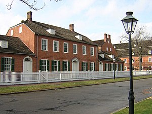
Old Economy Village
United States historic place
Distance: Approx. 1023 meters
Latitude and longitude: 40.59615833,-80.233
Old Economy Village is an historic settlement that is located in Ambridge, Beaver County, Pennsylvania, United States. Administered by the Pennsylvania Historical and Museum Commission, it lies on the banks of the Ohio River and is surrounded by downtown Ambridge. The village is the last of three settlements established by the Harmony Society in the United States (another in Pennsylvania and one in Indiana).
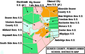
Ambridge Area School District
School district in Pennsylvania
Distance: Approx. 352 meters
Latitude and longitude: 40.592295,-80.225945
The Ambridge Area School District is a midsized, urban public school district in Beaver County, Pennsylvania. It serves the boroughs of Ambridge, Baden, Economy and South Heights and Harmony Township. The district encompasses approximately 27 square miles (70 km2).
North American Lutheran Seminary
Distance: Approx. 640 meters
Latitude and longitude: 40.593605,-80.229968
The North American Lutheran Seminary (NALS) is the seminary system of the North American Lutheran Church. The proposal resulted from the work of NALC's Task Force for Theological Education and recommended two components for the seminary system. The seminary describes itself as "not investing in bricks and mortar, but rather investing in people".
Ambridge Area High School
Public school in Ambridge, Beaver County, Pennsylvania, United States
Distance: Approx. 383 meters
Latitude and longitude: 40.5925,-80.2264
Ambridge High School is a midsized, suburban secondary school in Ambridge, Pennsylvania. By 2016, the school enrollment was reported as 749 pupils in grades 9th through 12th.
Weather in this IP's area
overcast clouds
-4 Celsius
-9 Celsius
-5 Celsius
-3 Celsius
1024 hPa
66 %
1024 hPa
983 hPa
10000 meters
3.6 m/s
70 degree
100 %