Country:
 Argentina
Region:
City:
Latitude and Longitude:
Time Zone:
Postal Code:
IP information under different IP Channel
ip-api
Country
Region
City
ASN
Time Zone
ISP
Blacklist
Proxy
Latitude
Longitude
Postal
Route
IPinfo
Country
Region
City
ASN
Time Zone
ISP
Blacklist
Proxy
Latitude
Longitude
Postal
Route
MaxMind
Country
Region
City
ASN
Time Zone
ISP
Blacklist
Proxy
Latitude
Longitude
Postal
Route
Luminati
Country
ARRegion
w
City
corrientes
ASN
Time Zone
America/Argentina/Cordoba
ISP
Internet Services S.A.
Latitude
Longitude
Postal
db-ip
Country
Region
City
ASN
Time Zone
ISP
Blacklist
Proxy
Latitude
Longitude
Postal
Route
ipdata
Country
Region
City
ASN
Time Zone
ISP
Blacklist
Proxy
Latitude
Longitude
Postal
Route
Popular places and events near this IP address

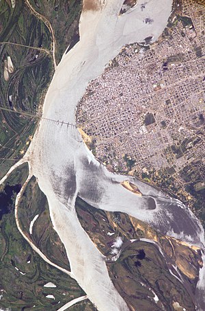
Corrientes
City in Argentina
Distance: Approx. 1298 meters
Latitude and longitude: -27.48333333,-58.81666667
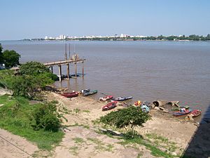
Corrientes (Spanish pronunciation: [koˈrjentes] ; Guaraní: Taragui, literally: "Currents") is the capital city of the province of Corrientes, Argentina, located on the eastern shore of the Paraná River, about 1,000 km (621 mi) from Buenos Aires and 300 km (186 mi) from Posadas, on National Route 12. It has a population of 346,334 according to the 2010 Census. It lies opposite its twin city, Resistencia, Chaco.
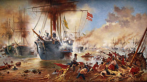
Battle of Riachuelo
1865 battle of the Paraguayan War
Distance: Approx. 8779 meters
Latitude and longitude: -27.56222222,-58.83916667
The Battle of Riachuelo was a large and decisive naval battle of the Paraguayan War between Paraguay and the Empire of Brazil. By late 1864, Paraguay had scored a series of victories in the war, but on 11 June 1865, its naval defeat by the Brazilians on the Paraná River began to turn the tide in favor of the allies.
General Belgrano Bridge
Bridge in Corrientes to Resistencia, Argentina
Distance: Approx. 3369 meters
Latitude and longitude: -27.470092,-58.860208
The General Manuel Belgrano Bridge (Spanish: Puente General Manuel Belgrano) is a road bridge that joins the Argentine cities of Corrientes (capital of the Corrientes Province in the Mesopotamia) and Resistencia (capital of Chaco in the Chaco Region) over the course of the Paraná River (near the confluence with the Paraguay River). It was opened on May 10, 1973. The bridge joins Corrientes' Provincial Route 12 with Chaco's Provincial Routes 11 and 16.

Río Negro (Chaco Province)
River in Argentina
Distance: Approx. 6809 meters
Latitude and longitude: -27.46888889,-58.89666667
Río Negro (Spanish for "black river") is a river in the Chaco Province in Argentina. It crosses the Chaco National Park and flows southeast. Near its mouth it flows by the cities of Puerto Tirol, Resistencia, and Barranqueras, where it finally reaches Barranqueras River, an arm of the Paraná River.
Doctor Fernando Piragine Niveyro International Airport
Airport in Argentina
Distance: Approx. 8019 meters
Latitude and longitude: -27.44916667,-58.75861111
Corrientes International Airport (IATA: CNQ, ICAO: SARC) (Spanish: Aeropuerto Internacional de Corrientes), also known as Doctor Fernando Piragine Niveyro International Airport (Spanish: Aeropuerto Internacional Doctor Fernando Piragine Niveyro and Cambá Punta) is an airport in Corrientes Province, Argentina, serving the city of Corrientes, built in 1961 while the terminal was completed in 1964. A new terminal and a new control tower were constructed between 2009 and 2011. The old buildings were demolished.

National University of the Northeast
Distance: Approx. 2413 meters
Latitude and longitude: -27.46388889,-58.83944444
The National University of the Northeast (Spanish: Universidad Nacional del Nordeste, UNNE) is an Argentine national university. It is located in the cities of Corrientes and Resistencia, capital cities of the Provinces of Corrientes and Chaco respectively, and was established on December 4, 1956. Known as the University of the Sun, it was the seventh-largest university in Argentina by student enrollment numbers as of 2017.
Barrio San Pedro Pescador
Municipality and village in Chaco Province, Argentina
Distance: Approx. 4522 meters
Latitude and longitude: -27.46111111,-58.86777778
Barrio San Pedro Pescador is a village and municipality in Chaco Province in northern Argentina, located on the thin coastal levee of the Paraná River. The town is located in the Primero de Mayo Department and reports administratively to the Colonia Benitez municipality. It occupies the left side of the Chaco end of the General Manuel Belgrano Bridge, which links the province of Chaco with the city of Corrientes.

University of Cuenca del Plata
Distance: Approx. 2483 meters
Latitude and longitude: -27.4746,-58.8527
The River Plate Basin University (in Spanish: Universidad de la Cuenca del Plata - UCP) is a non-profit private university founded in 1991. Located in the province of Corrientes, Argentina, it has an undergraduate enrollment of 1,100 students and a graduate enrollment of 600. The university is focused primarily on social sciences and engineering.
Barrio Esperanza
Town in Corrientes, Argentina
Distance: Approx. 8328 meters
Latitude and longitude: -27.5475,-58.78555556
Barrio Esperanza is a barrio under the administration of the city of Corrientes in Corrientes Province, Argentina. It is essentially a village in far southern suburbs, northwest of the village of Riachuelo. According to the 2001 population census conducted by INDEC its population was 2236 inhabitants.

Our Lady of the Rosary Cathedral, Corrientes
Church in Corrientes, Argentina
Distance: Approx. 1632 meters
Latitude and longitude: -27.4692,-58.8313
The Our Lady of the Rosary Cathedral (Spanish: Catedral Nuestra Señora del Rosario), also called Corrientes Cathedral, is a Roman Catholic church located in the city of Corrientes. Argentina The cathedral is within the Archdiocese of Corrientes. It is located at Hipólito Yrigoyen street 1542, compared to the Sargento Cabral square.
Weather in this IP's area
clear sky
23 Celsius
23 Celsius
22 Celsius
23 Celsius
1005 hPa
74 %
1005 hPa
998 hPa
7000 meters
4.63 m/s
70 degree
2 %
06:47:52
18:50:09